Butte County, South Dakota: Walk-In Areas, GPAs and public hunting land
Butte County has 238,977 acres of private land open to public hunting through GFP's Walk-In Area and CREP programs inside its line (45 tracts centered in the county), 2 game production areas covering 4,332 acres, and 220,345 acres of other public land, by the maps GFP publishes. That is 32% of the county's 1,450,636 acres.
Data updated October 2026. Walk-In Areas, CREP, school and public land, federal land and GPAs: GFP map layers. Units: GFP 2026 applications and harvest projections.
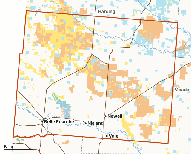
Game production area (GFP)BLMBureau of ReclamationSchool and public landState park or recreation area (rules vary)Other GFP land (access sites, lakes)Walk-In Area or CREP (private land open to hunting)Butte CountyNeighboring countiesLake or riverHighway
| Size | 1,450,636 acres (2,267 square miles) |
|---|---|
| Walk-In and CREP land inside the county line | 238,977 acres |
| Walk-In Area tracts centered in the county | 45 (243,825 acres in all) |
| Game production areas | 2, 4,332 acres |
| School and public land | 72,714 acres |
| Other public land | 147,631 acres |
| Deer units | Deer unit 15A, Deer unit 15B |
| Antelope units | Antelope unit 15A, Antelope unit 15B |
| Towns | Belle Fourche, Newell, Fruitdale, Nisland and Vale |
How much Walk-In Area land is in Butte County?
238,977 acres inside the county line, 16.5% of the county. 45 Walk-In Area tracts are centered in the county (243,825 acres in all). Walk-In Areas and CREP land are private ground GFP leases for public hunting. GFP's public hunting atlas shows each tract.
Which game production areas are in Butte County?
2 GPAs, 4,332 acres in all, largest first:
- Belle Fourche Reservoir GPA: 4,273 acres
- Duer Lake GPA: 59 acres
How much public land is in Butte County?
15.5% of the county is public land: 224,677 acres, counting the GPAs. The largest share is BLM, 145,513 acres.
| Manager | Acres | Share of the county |
|---|---|---|
| Walk-In Area or CREP (private land open to hunting) | 238,977 | 16.5% |
| BLM | 145,513 | 10% |
| School and public land | 72,714 | 5% |
| Game production area (GFP) | 4,332 | 0.3% |
| Bureau of Reclamation | 2,118 | 0.1% |
| Other GFP land (access sites, lakes) | 771 | 0.1% |
| State park or recreation area (rules vary) | 429 | under 0.1% |
Measured by FilledTag inside the Census county line from GFP public hunting atlas layers (Walk-In Areas, CREP, school and public land, federal land) and GFP Managed Lands; overlapping maps are counted once. GFP's handbook counts school and public land among South Dakota's public hunting lands; motor vehicles are not allowed on it except on designated, signed roads, trails and parking areas (page 73).
Which hunting units are in Butte County?
The units GFP names for Butte County, with their 2026 licenses and latest harvest projection, for the whole unit:
| Unit | GFP's description | Licenses, 2026 | Taken (GFP projection) |
|---|---|---|---|
| Deer unit 15A | Butte | 1,404 | 1,048 (2025) |
| Deer unit 15B | Southwest Butte / Northeast Lawrence | 810 | 638 (2025) |
| Antelope unit 15A | northwest Butte | 51 | 37 (2025) |
| Antelope unit 15B | Butte/north Lawrence | 255 | 155 (2025) |
Sources: GFP 2026 draw applications; GFP harvest projections.
How do you get around Butte County?
Highways: US 212 (about 69 miles in the county), US 85 (about 54 miles in the county), SD 79 (about 50 miles in the county), SD 34 (about 15 miles in the county) and SD 168 (about 7 miles in the county). Towns: Belle Fourche, Newell, Fruitdale, Nisland and Vale.
How do the counties around Butte compare?
| County | Walk-In and CREP acres | Tracts | GPA acres | Other public acres |
|---|---|---|---|---|
| Harding | 183,204 | 42 | 900 | 356,519 |
| Lawrence | 1,315 | 1 | 4,210 | 279,752 |
| Meade | 84,498 | 21 | 1,695 | 129,922 |
| Perkins | 117,767 | 63 | 7,030 | 204,458 |
Questions hunters ask
How much Walk-In Area land is in Butte County?
GFP's public hunting atlas shows 238,977 acres of Walk-In Area and CREP land inside Butte County's line, from 45 tracts centered in the county. No permission is needed to hunt a Walk-In Area; travel there is on foot except on signed trails, by GFP's handbook.
Are there game production areas in Butte County?
Yes, 2: Belle Fourche Reservoir (4,273 acres) and Duer Lake (59 acres).
What hunting units are in Butte County?
GFP names deer units 15A and 15B and antelope units 15A and 15B for Butte County in its 2026 applications.
How much public land is in Butte County?
15.5% of the county, 224,677 acres, is public land open to hunting under its manager's rules; the largest share is BLM at 145,513 acres.
Get a South Dakota hunt plan when they open
Hunt plans for South Dakota are coming. Join the list and you'll hear first. The first 50 hunters in each new state get their plan free.
Until then, the free FilledTag app for iPhone has a map that works in every state, South Dakota included.
Where these numbers come from
- Walk-In Areas, CREP, school and public land, federal land and GPAs: GFP public hunting atlas layers (Walk-In Areas, CREP, school and public land, federal land) and GFP Managed Lands.
- Units: GFP 2026 draw applications and harvest projections.
- County line, highways and towns: U.S. Census Bureau 2024 boundaries, TIGER/Line and Gazetteer.
FilledTag is not part of South Dakota Game, Fish and Parks. Walk-In Areas change each year; check GFP's current atlas before you go.
South Dakota hunting Harding County Lawrence County Meade County Perkins County