Paulson Game Production Area: hunting, map and access
Paulson Game Production Area is 1,556 acres of land managed by South Dakota Game, Fish and Parks, in Charles Mix County. Game production areas are open to public hunting under GFP's rules. Within 5 miles of this one are 808 acres of Walk-In Areas and CREP land and 594 acres of other public land.
Data updated October 2026. Boundary: GFP Managed Lands. Land around it: GFP public hunting atlas layers. Units: GFP 2026 applications.
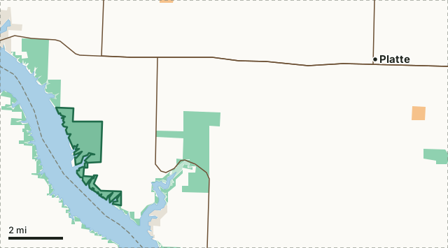
Game production area (GFP)BLMCorps of EngineersState park or recreation area (rules vary)Walk-In Area or CREP (private land open to hunting)Paulson GPACounty lineLake or riverHighway
| Size | 1,556 acres (measured from GFP's boundary) |
|---|---|
| County | Charles Mix |
| Deer units in the county | Deer unit 17A |
| Walk-In Areas and CREP within 5 miles | 808 acres |
| Nearest towns | Platte (10 mi), Bijou Hills (12 mi) and Burke (15 mi) |
What other hunting land is near Paulson GPA?
Within 5 miles of the GPA's boundary, GFP's maps show 808 acres of Walk-In Areas and CREP land (1 tract centered in that ring) and 594 acres of other public land. Other game production areas close by: Buryanek GPA (3,797 acres in the ring), Gray Area GPA (2,330 acres in the ring), West Platte GPA (835 acres in the ring), Central - Gregory GPA (385 acres in the ring), Center - Charles Mix GPA (354 acres in the ring) and Center - Platte GPA (243 acres in the ring).
| Within 5 miles | Acres |
|---|---|
| Game production area (GFP) | 7,971 |
| State park or recreation area (rules vary) | 925 |
| Walk-In Area or CREP (private land open to hunting) | 808 |
| Corps of Engineers | 589 |
| BLM | 5 |
Measured by FilledTag from GFP public hunting atlas layers (Walk-In Areas, CREP, school and public land, federal land) and GFP Managed Lands; land outside South Dakota is not counted.
How do you get to Paulson GPA?
Paulson GPA is about 10 miles west of Platte, and 12 miles south of Bijou Hills. Highways within 8 miles: SD 44 (18 miles of it), SD 50 (16 miles of it), SD 1804 (10 miles of it) and SD 1806 (6 miles of it). Hunting units: GFP names Deer unit 17A for Charles Mix County.
Questions hunters ask
How big is Paulson GPA?
1,556 acres, measured by FilledTag from GFP's Managed Lands boundary.
What county is Paulson GPA in?
Charles Mix County.
Is there other public hunting land near Paulson GPA?
Within 5 miles, GFP's maps show 808 acres of Walk-In Areas and CREP land and 594 acres of other public land, plus Buryanek GPA, Gray Area GPA and West Platte GPA.
What is the closest town to Paulson GPA?
Platte (10 miles), Bijou Hills (12 miles) and Burke (15 miles).
Get a South Dakota hunt plan when they open
Hunt plans for South Dakota are coming. Join the list and you'll hear first. The first 50 hunters in each new state get their plan free.
Until then, the free FilledTag app for iPhone has a map that works in every state, South Dakota included.
Where these facts come from
- Boundary: GFP Managed Lands. Land around it: GFP public hunting atlas layers (Walk-In Areas, CREP, school and public land, federal land) and GFP Managed Lands.
- Units: GFP 2026 west river deer application; GFP 2026 east river deer application; GFP 2026 firearm antelope application.
FilledTag is not part of South Dakota Game, Fish and Parks. Posted rules and GFP's handbook are the final word.