Clay County deer harvest: Tennessee, 2015-16 to 2025-26
Hunters checked in 934 deer in Clay County outside its WMAs in the 2025-26 season: 501 antlered bucks, 43 antlerless males and 390 females (TWRA's Hunter's Toolbox). That is 3.9 deer per square mile of land, 76th of Tennessee's 95 counties by total. Deer from WMAs are counted on each WMA's page. The count was 14% below 2024-25 (1,091). The county is in deer management Unit 3.
Data updated October 2026. Harvest: TWRA's Hunter's Toolbox to the 2025-26 season. Seasons and limits: TWRA's 2026-27 guide.
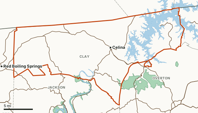
Clay CountyTWRA hunting landsNational wildlife refugeLake or riverHighwayCounty line
| Deer checked in off WMAs, 2025-26 | 934 (501 antlered bucks, 390 females) |
|---|---|
| Per square mile of land | 3.9, 29th of 95 |
| Average, 11 seasons | 845 deer a season |
| Highest season | 1,091 in 2024-25 |
| Antlered share, 2025-26 | 54% |
| Deer management unit | Unit 3: antlerless limit 3 a day in every season but the August hunt |
| TWRA region | Region 3 |
| Land area | 236.5 square miles (Census) |
| Public land mapped here | 2 TWRA hunting areas, 415 acres |
| Towns | Celina |
How many deer are killed in Clay County each season?
TWRA's Hunter's Toolbox shows Clay County's deer for 11 seasons. The average was 845 a season; the most was 1,091 in 2024-25 and the fewest 663 in 2021-22. 2025-26 was 8% above 2015-16.
| Season | Deer checked in off WMAs | Males | Antlered | Females | Per square mile |
|---|---|---|---|---|---|
| 2025-26 | 934 | 544 | 501 | 390 | 3.9 |
| 2024-25 | 1,091 | 654 | 609 | 437 | 4.6 |
| 2023-24 | 699 | 490 | 459 | 208 | 3 |
| 2022-23 | 854 | 589 | 562 | 265 | 3.6 |
| 2021-22 | 663 | 472 | 448 | 191 | 2.8 |
| 2020-21 | 920 | 639 | 605 | 281 | 3.9 |
| 2019-20 | 768 | 546 | 528 | 222 | 3.2 |
| 2018-19 | 839 | 565 | 538 | 274 | 3.5 |
| 2017-18 | 793 | 535 | 258 | 3.4 | |
| 2016-17 | 869 | 552 | 317 | 3.7 | |
| 2015-16 | 866 | 606 | 260 | 3.7 |
Source: TWRA Hunter's Toolbox, Deer Harvests by County / WMA, read October 2026: deer hunters reported at check-in. The Toolbox's county counts leave out deer taken on WMAs, which it reports by WMA. Before 2018-19 the Toolbox counts every male as antlerless, so only the male total is shown. Per square mile uses the county's 236.5 square miles of land (Census).
What are the deer seasons and limits in Clay County for 2026-27?
Clay County is in deer management Unit 3. The antlered limit is two for the season, one a day, statewide.
| Season | Dates | Antlerless limit, Unit 3 |
|---|---|---|
| August (archery only; private land and select Unit 1 WMAs) | Aug. 28 to 30, 2026 | No antlerless harvest |
| Young Sportsman (gun, muzzleloader, archery; ages 6 to 16) | Oct. 31 to Nov. 1, 2026; Jan. 9 to 10, 2027 | 3 a day |
| Archery | Sept. 26 to Oct. 30 and Nov. 2 to 6, 2026 | 3 a day |
| Muzzleloader and archery | Nov. 7 to 20, 2026 | 3 a day |
| Straight-walled single-shot rifles, private land only | Nov. 14 to 20, 2026 | 3 a day |
| Gun, muzzleloader and archery | Nov. 21, 2026 to Jan. 3, 2027 | 3 a day |
Source: TWRA 2026-27 Tennessee Hunting, Fishing and Trapping Guide, page 67; county units: TWRA deer management unit counties. WMAs set their own hunts: see each area's page.
Where is the public hunting land in Clay County?
| Area | Acres in Clay County | Deer from the whole area, 2025-26 |
|---|---|---|
| Cordell Hull WMA | 216 | 343 |
| Standing Stone State Forest and WMA | 199 | 62 |
Acres measured by FilledTag on TWRA hunting lands layer (HuntingAllowed), U.S. Forest Service national forest ownership and U.S. Fish and Wildlife Service refuge boundaries.
How does Clay County compare with its neighbors?
| County | Unit | Deer off WMAs, 2025-26 | Per square mile | Change since 2015-16 |
|---|---|---|---|---|
| Clay County | 3 | 934 | 3.9 | 8% |
| Jackson County | 3 | 1,941 | 6.3 | 0% |
| Macon County | 3 | 1,717 | 5.6 | 55% |
| Overton County | 3 | 1,544 | 3.6 | 14% |
| Pickett County | 4 | 343 | 2.1 | -5% |
Questions hunters ask
How many deer were killed in Clay County, Tennessee last season?
Hunters checked in 934 deer in Clay County outside its WMAs in the 2025-26 season: 501 antlered bucks, 43 antlerless males and 390 females, by TWRA's Hunter's Toolbox. The Toolbox counts deer from WMAs apart, by WMA.
What is the antlerless limit in Clay County?
Clay County is in deer management Unit 3 for 2026-27. The antlerless limit there is 3 a day in every season but the August hunt. The antlered limit is two statewide, one a day (TWRA 2026-27 guide, page 67).
Is there public hunting land in Clay County?
Yes. TWRA's map puts Cordell Hull WMA (216 acres in the county) and Standing Stone State Forest and WMA (199 acres in the county) in Clay County.
Has the deer harvest in Clay County gone up or down?
From 866 in 2015-16 to 934 in 2025-26, 8% higher. The high in that span was 1,091 (2024-25) and the low 663 (2021-22).
Get a Tennessee hunt plan when they open
Hunt plans for Tennessee are coming. Join the list and you'll hear first. The first 50 hunters in each new state get their plan free.
Until then, the free FilledTag app for iPhone has a map that works in every state, Tennessee included.
Where these numbers come from
- Deer harvest: TWRA Hunter's Toolbox, Deer Harvests by County / WMA.
- Deer units, seasons and limits: TWRA 2026-27 Tennessee Hunting, Fishing and Trapping Guide, pages 66 to 67; TWRA deer management unit counties.
- Public land: TWRA hunting lands layer (HuntingAllowed); U.S. Forest Service national forest ownership; U.S. Fish and Wildlife Service refuge boundaries. County land area: U.S. Census Bureau 2024 county boundaries. Highways and towns: U.S. Census Bureau TIGER/Line 2024 roads; U.S. Census Bureau 2024 Gazetteer.
FilledTag is not part of Tennessee Wildlife Resources Agency. Numbers are copied from TWRA and the Census Bureau or measured from public maps; nothing here is estimated by FilledTag.
Tennessee hunting Tennessee deer harvest by county Jackson County Macon County Overton County Pickett County