The Boils WMA: deer harvest, 2026-27 rules and map
The Boils WMA is 268 acres of TWRA hunting land in Jackson County, measured on TWRA's boundary, in its Region 3. Hunters checked in 5 deer from the area in the 2025-26 season, 2 antlered bucks among them (TWRA's Hunter's Toolbox). For the area's seasons, TWRA's guide says: Same as statewide seasons, except as noted.
Data updated October 2026. Rules: TWRA's 2026-27 guide, page 111. Harvest: TWRA's Hunter's Toolbox, 2015-16 to 2025-26.
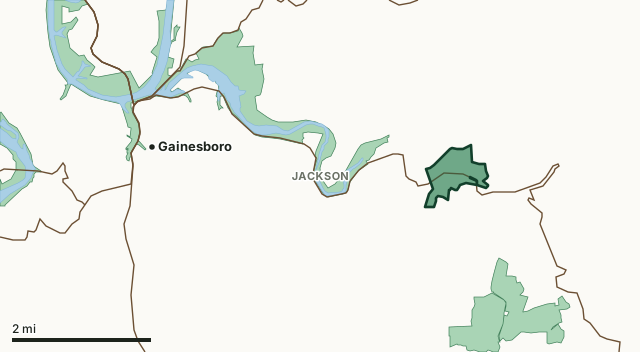
The Boils WMAOther TWRA hunting landsLake or riverHighwayCounty line
| Size | 268 acres, measured on TWRA's boundary; the guide lists 119 |
|---|---|
| County | Jackson County |
| TWRA region | Region 3 |
| Deer management unit | Unit 3 |
| Permits | WMA Small Game permit; WMA Waterfowl/Small Game permit; Big Game (Non-Quota/WMA) or quota permit |
| Deer checked in, 2025-26 | 5 (2 antlered bucks, 3 antlerless males, 0 females) |
| Area manager | JOHNNY POSTON |
| Nearest towns | Gainesboro (4 mi), Algood (12 mi) and Livingston (13 mi) |
What are the 2026-27 hunting rules on The Boils WMA?
TWRA's 2026-27 guide prints these rules and seasons for the area. Where it says statewide seasons, the statewide dates and the county's deer management unit limits apply.
Use of motorized vehicles prohibited.
Same as statewide seasons, except as noted. Closed to quail hunting.
- Dog training: Sept. 1–March 15.
Source: TWRA 2026-27 Tennessee Hunting, Fishing and Trapping Guide, page 111; TWRA's page for the area. Read every rule in the guide before you go: the guide is the final word.
How many deer are taken on The Boils WMA?
Hunters checked in 5 deer from The Boils WMA in the 2025-26 season. Over the 11 seasons the Toolbox shows, the area averaged 6 deer a season, from 3 in 2023-24 to 14 in 2024-25.
| Season | Deer checked in | Males | Antlered | Antlerless males | Females |
|---|---|---|---|---|---|
| 2025-26 | 5 | 5 | 2 | 3 | 0 |
| 2024-25 | 14 | 8 | 7 | 1 | 6 |
| 2023-24 | 3 | 3 | 2 | 1 | 0 |
| 2022-23 | 7 | 3 | 2 | 1 | 4 |
| 2021-22 | 5 | 5 | 4 | 1 | 0 |
| 2020-21 | 5 | 3 | 1 | 2 | 2 |
| 2019-20 | 3 | 2 | 2 | 0 | 1 |
| 2018-19 | 7 | 5 | 5 | 0 | 2 |
| 2017-18 | 6 | 3 | 3 | ||
| 2016-17 | 3 | 0 | 3 | ||
| 2015-16 | 5 | 3 | 2 |
Source: TWRA Hunter's Toolbox, Deer Harvests by County / WMA, read October 2026. These are deer hunters reported at check-in. Before 2018-19 the Toolbox counts every male as antlerless, so only the male total is shown for those seasons.
Which county is The Boils WMA in?
| County | Acres of the area in it | Deer unit | County deer off WMAs, 2025-26 | Rank of 95 |
|---|---|---|---|---|
| Jackson County | 268 | 3 | 1,941 | 24th |
Acres measured by FilledTag on TWRA hunting lands layer (HuntingAllowed) and the U.S. Census Bureau 2024 county boundaries. County harvest: TWRA Hunter's Toolbox, Deer Harvests by County / WMA. Units: TWRA deer management unit counties.
How do you get to The Boils WMA?
Highways through the area: TN 135. Nearest towns: Gainesboro (4 miles), Algood (12 miles), Livingston (13 miles) and Baxter (14 miles). Directions and the area map are on TWRA's page for The Boils WMA.
The closest other TWRA hunting lands with a page here: Cordell Hull WMA (next to it), Blackburn Fork WMA (1 miles), Cordell Hull Refuge (4.1 miles) and Standing Stone State Forest and WMA (7.5 miles).
Questions hunters ask
When can you hunt deer on The Boils WMA in 2026-27?
TWRA's guide says: Same as statewide seasons, except as noted. That means the statewide dates: archery from September 26, 2026, muzzleloader from November 7 and gun from November 21, 2026 to January 3, 2027.
How many deer were killed on The Boils WMA last season?
Hunters checked in 5 deer from The Boils WMA in the 2025-26 season: 2 antlered bucks, 3 antlerless males and 0 females, by TWRA's Hunter's Toolbox. The 11-season average is 6.
What county is The Boils WMA in?
All of it is in Jackson County, by TWRA's boundary, in deer management Unit 3.
What permit do you need to hunt The Boils WMA?
TWRA's guide lists these for the area: WMA Small Game permit; WMA Waterfowl/Small Game permit; Big Game (Non-Quota/WMA) or quota permit. Lifetime and Annual Sportsman License holders are exempt from WMA permits (guide, page 11).
Get a Tennessee hunt plan when they open
Hunt plans for Tennessee are coming. Join the list and you'll hear first. The first 50 hunters in each new state get their plan free.
Until then, the free FilledTag app for iPhone has a map that works in every state, Tennessee included.
Where these numbers come from
- Area rules, seasons, size and manager: TWRA 2026-27 Tennessee Hunting, Fishing and Trapping Guide.
- Deer harvest on the area and by county: TWRA Hunter's Toolbox, Deer Harvests by County / WMA.
- Boundary: TWRA hunting lands layer (HuntingAllowed). Counties, highways and towns: U.S. Census Bureau 2024 county boundaries; U.S. Census Bureau TIGER/Line 2024 roads; U.S. Census Bureau 2024 Gazetteer. National forest and refuges: U.S. Forest Service national forest ownership; U.S. Fish and Wildlife Service refuge boundaries.
FilledTag is not part of Tennessee Wildlife Resources Agency. Numbers are copied from TWRA or measured from public maps; nothing on this page is estimated by FilledTag.
Tennessee hunting All Tennessee WMAs Jackson County deer harvest