Densmore Hill Wildlife Management Area: hunting, map and deer in WMU O
Densmore Hill Wildlife Management Area is 251 acres of Vermont Fish and Wildlife Department land in Windsor County, inside WMU O. VFWD's sheet says it is open to regulated hunting, trapping, fishing, hiking and wildlife viewing. A legal buck here needs at least one antler with two or more points 1 inch or longer, and hunters took 956 deer in WMU O in 2025.
Data updated October 2026. Boundary: ANR. Description: VFWD's Densmore Hill WMA sheet, last edited 9/30/22. Seasons: VFWD 2026 Vermont White-tailed Deer Seasons.
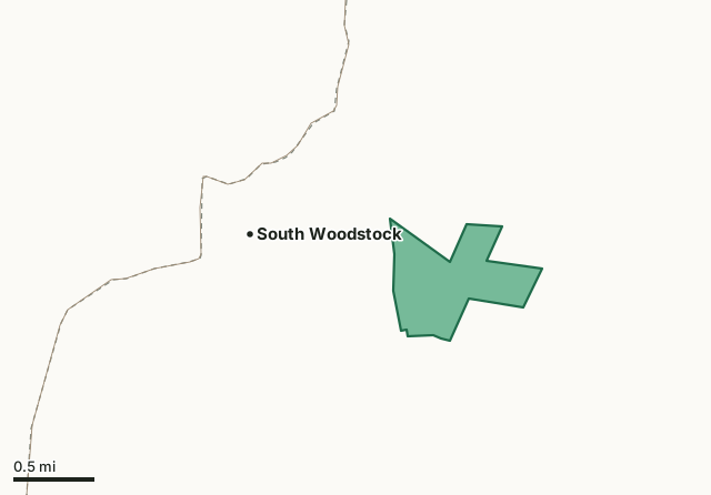
Fish and Wildlife landDensmore Hill WMAWMU lineHighway
| Size | 251 acres (ANR) |
|---|---|
| County | Windsor |
| Wildlife Management Unit | WMU O |
| VFWD region | Southeast |
| Open to (VFWD) | regulated hunting, trapping, fishing, hiking and wildlife viewing |
| Game named on VFWD's sheet | white-tailed deer, wild turkey, ruffed grouse, woodcock, snowshoe hare and waterfowl |
| Legal buck, 2026 | At least one antler with two or more points 1 inch or longer |
| Deer taken in WMU O, 2025 | 956 (524 bucks) |
| Nearest villages | South Woodstock (next to it), West Woodstock (4 mi) and Woodstock (4 mi) |
What is Densmore Hill WMA like?
Of the land: "Ranging in elevation from 1,249 feet to 1,548 feet, the parcel's terrain is rugged, sloping steeply up to the north and east from Cady Brook to a ridgeline that runs northwest to southeast." On its past: "During the mid- 1800's, the land comprising Densmore Hill WMA was owned by Isaac Cobb and Alvin Dutton." On its animals: "Snowshoe hare and beaver live out their entire lives on portions of the WMA." The sheet names white-tailed deer, wild turkey, ruffed grouse, woodcock, snowshoe hare and waterfowl among its wildlife.
Quoted from VFWD's Densmore Hill WMA sheet. VFWD notes its WMA maps are a general guide, not survey boundaries.
When can you hunt Densmore Hill WMA in 2026?
Seasons follow WMU O: archery October 1 to December 15, youth and novice weekend November 7 to 8, regular season November 14 to 29 and December muzzleloader November 30 to December 13. A legal buck needs at least one antler with two or more points 1 inch or longer. Fall turkey: bow and arrow October 1 to November 13; shotgun or bow October 24 to November 1.
| WMU | WMA acres in it | Deer, 2025 | Bucks, 2025 | Bears, 2025 | Legal buck |
|---|---|---|---|---|---|
| WMU O | 251 | 956 | 524 | 49 | two points on one antler |
Seasons: VFWD 2026 Vermont White-tailed Deer Seasons; VFWD 2026 Vermont Hunting and Trapping Seasons. Harvest: VFWD 2025 White-tailed Deer Harvest Report; VFWD 2025 Black Bear Harvest Report.
How do you get to Densmore Hill WMA?
Highways within five miles: VT 106, VT 12, US 4, I-91 and US 5. Nearest villages: South Woodstock (next to it), West Woodstock (4 miles), Woodstock (4 miles) and Hartland (5 miles). Other WMAs nearby: Arthur Davis (8 miles), Little Ascutney (9 miles), Knapp Brook (9 miles).
Questions hunters ask
Can you hunt on Densmore Hill WMA?
Yes. VFWD's sheet says Densmore Hill WMA is open to regulated hunting, trapping, fishing, hiking and wildlife viewing. Seasons and the legal buck rule follow WMU O: a buck needs at least one antler with two or more points 1 inch or longer, and the 2026 regular deer season runs November 14 to 29.
What WMU is Densmore Hill WMA in?
WMU O. Hunters took 956 deer in WMU O in 2025, 524 of them bucks, and 49 bears (VFWD).
Where is Densmore Hill WMA?
In Windsor County, inside WMU O. The nearest villages are South Woodstock (next to it), West Woodstock (4 miles) and Woodstock (4 miles).
What game lives on Densmore Hill WMA?
VFWD's sheet for the area names white-tailed deer, wild turkey, ruffed grouse, woodcock, snowshoe hare and waterfowl. It does not count them; the WMU figures on this page are the nearest harvest numbers.
Get a Vermont hunt plan when they open
Hunt plans for Vermont are coming. Join the list and you'll hear first. The first 50 hunters in each new state get their plan free.
Until then, the free FilledTag app for iPhone has a map that works in every state, Vermont included.
Where these facts come from
- Boundary and acres: Vermont ANR land units (Wildlife Management Areas). Description: VFWD's WMA sheets, linked from its regional WMA pages.
- Seasons: VFWD 2026 Vermont White-tailed Deer Seasons; VFWD 2026 Vermont Hunting and Trapping Seasons. WMU harvest: VFWD 2025 White-tailed Deer Harvest Report; VFWD 2025 Black Bear Harvest Report.
- Public land around it: Vermont ANR land units (state forests, parks and Fish and Wildlife land) for state land; USGS Protected Areas Database of the United States (PAD-US 4.1) for federal land. Highways and villages: U.S. Census Bureau TIGER/Line 2024 primary and secondary roads; U.S. Census Bureau 2024 Gazetteer, places.
FilledTag is not part of the Vermont Fish and Wildlife Department.