The Narrows Wildlife Management Area: hunting, map and deer in WMU K
The Narrows Wildlife Management Area is 401 acres of Vermont Fish and Wildlife Department land in Rutland County, inside WMU K. VFWD's sheet says it is open to regulated hunting, trapping, fishing, hiking and wildlife viewing. A legal buck here needs at least one antler with two or more points 1 inch or longer, and hunters took 1,175 deer in WMU K in 2025.
Data updated October 2026. Boundary: ANR. Description: VFWD's The Narrows WMA sheet, last edited 9/30/22. Seasons: VFWD 2026 Vermont White-tailed Deer Seasons.
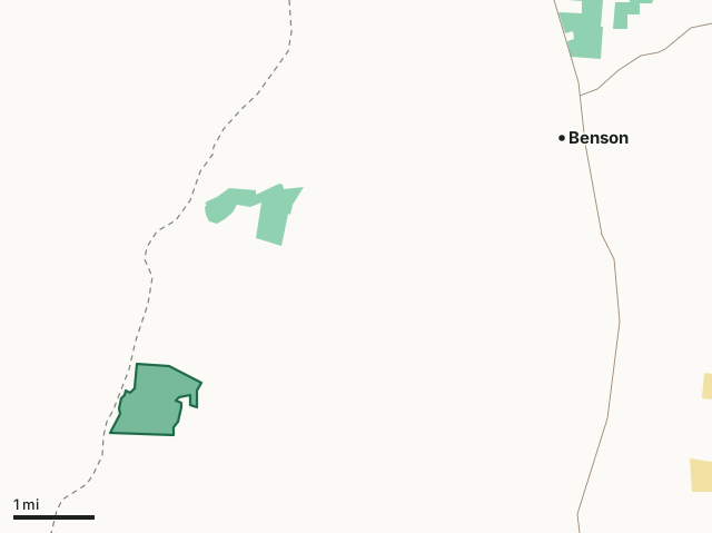
Fish and Wildlife landState parkThe Narrows WMAWMU lineHighway
| Size | 401 acres (ANR) |
|---|---|
| County | Rutland |
| Wildlife Management Unit | WMU K |
| VFWD region | Southwest |
| Open to (VFWD) | regulated hunting, trapping, fishing, hiking and wildlife viewing |
| Game named on VFWD's sheet | white-tailed deer, wild turkey, ruffed grouse, woodcock and waterfowl |
| Legal buck, 2026 | At least one antler with two or more points 1 inch or longer |
| Deer taken in WMU K, 2025 | 1,175 (627 bucks) |
| Nearest villages | Benson (5 mi), Fair Haven (8 mi) and Castleton Four Corners (10 mi) |
What is The Narrows WMA like?
VFWD describes where it is: "It is located in the "Dresden Narrows" section of Lake Champlain, west of Cold Spring Road in the town of West Haven." Of the land: "The Narrows WMA has 81acres of wetlands that is part of a series of large wetlands in this area of Lake Champlain." On its past: "George Spiegel conveyed the 716- acre Spiegel Sanctuary in West Haven to the Vermont Land Trust in 1995 in memory of his parents, Charles and Lena Spiegel." On its animals: "The Narrows WMA is a rich habitat that supports a wide variety of animals." The sheet names white-tailed deer, wild turkey, ruffed grouse, woodcock and waterfowl among its wildlife. On parking: "A parking area is located near the sharp turn on Cold Spring Road."
Quoted from VFWD's The Narrows WMA sheet. VFWD notes its WMA maps are a general guide, not survey boundaries.
When can you hunt The Narrows WMA in 2026?
Seasons follow WMU K: archery October 1 to December 15, youth and novice weekend November 7 to 8, regular season November 14 to 29 and December muzzleloader November 30 to December 13. A legal buck needs at least one antler with two or more points 1 inch or longer. Fall turkey: bow and arrow October 1 to November 13; shotgun or bow October 24 to November 8.
| WMU | WMA acres in it | Deer, 2025 | Bucks, 2025 | Bears, 2025 | Legal buck |
|---|---|---|---|---|---|
| WMU K | 401 | 1,175 | 627 | 41 | two points on one antler |
Seasons: VFWD 2026 Vermont White-tailed Deer Seasons; VFWD 2026 Vermont Hunting and Trapping Seasons. Harvest: VFWD 2025 White-tailed Deer Harvest Report; VFWD 2025 Black Bear Harvest Report.
How do you get to The Narrows WMA?
Highways within five miles: VT 22A. Nearest villages: Benson (5 miles), Fair Haven (8 miles), Castleton Four Corners (10 miles) and Castleton (11 miles). Other WMAs nearby: Ward Marsh (6 miles), Marsh Pond (7 miles), Pond Woods (8 miles).
Questions hunters ask
Can you hunt on The Narrows WMA?
Yes. VFWD's sheet says The Narrows WMA is open to regulated hunting, trapping, fishing, hiking and wildlife viewing. Seasons and the legal buck rule follow WMU K: a buck needs at least one antler with two or more points 1 inch or longer, and the 2026 regular deer season runs November 14 to 29.
What WMU is The Narrows WMA in?
WMU K. Hunters took 1,175 deer in WMU K in 2025, 627 of them bucks, and 41 bears (VFWD).
Where is The Narrows WMA?
VFWD: "It is located in the "Dresden Narrows" section of Lake Champlain, west of Cold Spring Road in the town of West Haven." The nearest villages are Benson (5 miles), Fair Haven (8 miles) and Castleton Four Corners (10 miles).
What game lives on The Narrows WMA?
VFWD's sheet for the area names white-tailed deer, wild turkey, ruffed grouse, woodcock and waterfowl. It does not count them; the WMU figures on this page are the nearest harvest numbers.
Get a Vermont hunt plan when they open
Hunt plans for Vermont are coming. Join the list and you'll hear first. The first 50 hunters in each new state get their plan free.
Until then, the free FilledTag app for iPhone has a map that works in every state, Vermont included.
Where these facts come from
- Boundary and acres: Vermont ANR land units (Wildlife Management Areas). Description: VFWD's WMA sheets, linked from its regional WMA pages.
- Seasons: VFWD 2026 Vermont White-tailed Deer Seasons; VFWD 2026 Vermont Hunting and Trapping Seasons. WMU harvest: VFWD 2025 White-tailed Deer Harvest Report; VFWD 2025 Black Bear Harvest Report.
- Public land around it: Vermont ANR land units (state forests, parks and Fish and Wildlife land) for state land; USGS Protected Areas Database of the United States (PAD-US 4.1) for federal land. Highways and villages: U.S. Census Bureau TIGER/Line 2024 primary and secondary roads; U.S. Census Bureau 2024 Gazetteer, places.
FilledTag is not part of the Vermont Fish and Wildlife Department.