Klickitat Wildlife Area: hunting, units and access
The Klickitat Wildlife Area is 27,794 acres of land managed by WDFW in Region 5, in 8 units, inside GMUs 388, 382 and 578, measured from WDFW's boundary. The busiest elk unit it touches is GMU 578, where WDFW reports 47 elk taken in 2025.
Data updated October 2026. Area facts: WDFW's page for the Klickitat Wildlife Area, read 2026-10-18, and WDFW's facility data. Harvest: WDFW reports to 2025.
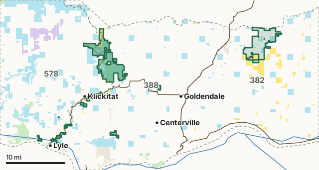
National forestBLMDNR state trust landWDFW landNational wildlife refuge (refuge rules; not counted)Military land (restricted)Other public (parks, county, city, other agencies)Klickitat Wildlife AreaGMU lineLake or riverHighway
| Size | 27,794 acres (WDFW boundary, measured by FilledTag) |
|---|---|
| WDFW region | Region 5, Southwest Washington |
| GMUs | GMU 388, GMU 382, GMU 578 |
| Units | 8 |
| Roads and trails | 118 miles |
| Parking areas | 13 |
| Campgrounds | 4 |
| Boat ramps | 3 |
| Nearest towns | Goldendale (4 mi), Bingen (7 mi) and White Salmon (8 mi) |
What is the Klickitat Wildlife Area like?
The Klickitat Wildlife Area is located in Klickitat County on the east slope of the Cascade Mountains, about halfway between the Columbia River Gorge to the south and Mt. Adams to the north. The wildlife area spans approximately 27,800 acres across units bordering the Klickitat River, which are fed by Mt. Adams glaciers and supports federally listed steelhead, spring Chinook and bull trout. The wildlife area is managed to provide access to the Klickitat River's summer-run steelhead fishery, but additionally provides black-tailed deer wintering range and important habitat for the Western gray squirrel and Vaux's swift. The area includes diverse vegetation in forested riparian zones along the Klickitat River, south-facing hillsides of open grasslands, north-facing hillsides forested with conifers, and a flat plateau covered by mixed forests of oak and pine interspersed with small grassland openings. There are 19 wildlife ponds and numerous springs located throughout the area. Wildlife use is diverse, from elk to western pond turtles. By actively managing lands, restoring habitats, and preserving wild places, the department serves as stewards for Washington's natural places, protecting the state's land and water for its human and wildlife populations.
In WDFW's words, from WDFW's Klickitat Wildlife Area page.
What units make up the Klickitat Wildlife Area?
WDFW manages the area as 8 units. The largest is Soda Springs at 13,939 acres.
| Unit | Acres | GMUs | Parking areas | Campgrounds | Hunting blinds |
|---|---|---|---|---|---|
| Soda Springs | 13,939 | 388, 578 | 7 | 2 | 0 |
| Simcoe Mountains | 10,940 | 382 | 1 | 0 | 0 |
| Mineral Springs | 1,101 | 388, 578 | 1 | 1 | 0 |
| Swale Creek | 520 | 388 | 0 | 0 | 0 |
| Fisher Hill | 503 | 388, 578 | 0 | 0 | 0 |
| Dillacort Canyon | 329 | 388, 578 | 2 | 1 | 0 |
| Goldendale Hatchery | 234 | 388 | 2 | 0 | 0 |
| Sondino Ponds | 227 | 578 | 0 | 0 | 0 |
Unit outlines and facilities: WDFW wildlife area and unit boundaries. Acres measured by FilledTag.
WDFW's notes for each unit
Soda Springs: No hunting with firearms is allowed within 500 feet of the Stinson Flat or Leidl Park Campgrounds (WAC 220-500-140) WDFW
Simcoe Mountains: General hunting seasons apply for GMU 382 East Klickitat. WDFW
Mineral Springs: No hunting with firearms is allowed within 500 feet of the Mineral Springs Campground (WAC 220-500-140). WDFW
Swale Creek: The Swale Creek Unit primarily offers upland bird hunting, with gray partridge as the primary hunting focus. The unit also offers black-tailed deer hunting opportunities. WDFW
Fisher Hill: Black-tailed deer and turkey are the most commonly hunted species on this unit. WDFW
Dillacort Canyon: No hunting with firearms is allowed within 500 feet of the Turkey Hole Campground. (WAC 232-13-130) WDFW
Goldendale Hatchery: Hunting of marmots is not allowed. WDFW
How many elk and deer are taken in the GMUs around the Klickitat Wildlife Area?
WDFW reports harvest by GMU, not by wildlife area. These are the whole GMUs the area lies in:
| GMU | Wildlife area acres in it | Elk taken, 2025 | Deer taken, 2025 | Bears taken, 2025 |
|---|---|---|---|---|
| GMU 388 Grayback | 12,952 | 8 | 169 | 3 |
| GMU 382 East Klickitat | 10,892 | 9 | 267 | 7 |
| GMU 578 West Klickitat | 3,902 | 47 | 195 | 19 |
Harvest: WDFW Game Harvest Reports (GMU, 2025). Wildlife area acres in each GMU measured by FilledTag from WDFW's boundaries.
How do you get to the Klickitat Wildlife Area?
Highways within 5 miles: SR 142 and US 97. Nearest towns: Goldendale (4 miles), Bingen (7 miles), White Salmon (8 miles) and Stevenson (28 miles).
Questions hunters ask
Do you need a pass to park at the Klickitat Wildlife Area?
Yes. Parking on WDFW land needs the Vehicle Access Pass that comes with most annual hunting and fishing licenses, or a Discover Pass, displayed where it can be seen from outside the vehicle (WDFW pamphlet, page 72).
Which GMUs is the Klickitat Wildlife Area in?
GMU 388 Grayback (12,952 acres), GMU 382 East Klickitat (10,892 acres) and GMU 578 West Klickitat (3,902 acres), by WDFW's boundaries. Seasons follow each GMU's rules.
Can you camp on the Klickitat Wildlife Area?
WDFW's facility data lists 4 campgrounds on the Klickitat Wildlife Area. Follow the posted rules and WDFW's public conduct rules.
Get a Washington hunt plan when they open
Hunt plans for Washington are coming. Join the list and you'll hear first. The first 50 hunters in each new state get their plan free.
Until then, the free FilledTag app for iPhone has a map that works in every state, Washington included.
Where these facts come from
- Area description, rules and access notes: WDFW, Klickitat Wildlife Area.
- Boundary, units and facilities: WDFW wildlife area and unit boundaries. Surrounding public land: WA DNR Major Public Lands (non-DNR) and WA DNR Managed Land Parcels, read 2026-10.
- GMU harvest: WDFW Game Harvest Reports. Parking passes: WDFW 2026 Big Game Hunting Seasons and Regulations, page 72.
FilledTag is not part of Washington Department of Fish and Wildlife. Numbers are copied from WDFW and the State of Washington, or measured from their maps; nothing on this page is estimated by FilledTag. WDFW's regulations are the final word on every rule.
Washington hunting Region 5 GMU 388 elk GMU 382 elk GMU 578 elk