Albany Wildlife Area: hunting and access
Albany Wildlife Area is 1,954 acres of land managed by the Wisconsin DNR in Green County, next to Albany. The DNR's page for it names deer, wild turkey, pheasants, ducks and geese and small game among the game here. Hunters registered 2,562 deer in Green County in 2025.
Data updated October 2026. Area facts: the DNR's DNR property data, read 2026-10. Harvest: DNR Deer Metrics.
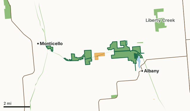
State wildlife areas, forests and other DNR landOther federal landState parksVoluntary Public Access landAlbany Wildlife AreaCounty lineLakeHighway
| Size | 1,954 acres in 12 pieces |
|---|---|
| County | Green County |
| Deer Management Unit | Green County |
| DNR lists for hunting | deer, wild turkey, pheasants, ducks and geese and small game |
| Public access (DNR) | Open to Hiking, Fishing, Hunting and Trapping |
| DNR property page | Albany Wildlife Area |
| Nearest towns | Albany (next to it), Monticello (next to it) and New Glarus (6 mi) |
What is Albany Wildlife Area like?
Albany Wildlife Area is located outside the village of Albany in Green County. There are 1,429 acres of state-owned land. Embedded within the wildlife area, is the 90-acre Albany Sand Prairie and Oak Savanna State Natural Area (No. 680) located in the northeast part of the property.
The department has acquired parcels through the statewide Extensive Wildlife Habitat (EWH) and Scattered Wildlife (SW) programs. The EWH parcels (580 acres) lie upstream of the Albany Wildlife Area along the Little Sugar River between the wildlife area and the Village of Monticello. The fourth parcel is a small SW parcel (20 acres) located northeast of Albany Wildlife Area with frontage on both the Sugar River and Allen Creek. Approximately 8 miles of the Sugar River State Trail intersects a portion of these properties and is included in the Southern Savanna Region of the Great Wisconsin Birding and Nature Trail by offering quality bird observation sites. Habitat types include a floodplain forest and open wetlands that are subject to seasonal flooding. Other acreage is restored or maintained native prairie, upland shrub, and oak woodland, along with varying cropland.
In the DNR's words, from its page for the property.
What can you hunt on Albany Wildlife Area?
The DNR's page for Albany Wildlife Area names deer, wild turkey, pheasants, ducks and geese and small game. Each follows Wisconsin's statewide season and, for deer, the tags and rules of the deer management unit.
What are the rules on Albany Wildlife Area?
The DNR's property map lists Albany Wildlife Area as "Open to Hiking, Fishing, Hunting and Trapping". Hunting follows Wisconsin's statewide seasons and the rules posted on the property.
Activities the DNR lists for Albany Wildlife Area: Biking (Sugar River State Trail), Birding, Boating (motorized and non-motorized), Canoeing, Cross-country skiing (no designated trail), Fishing, Hiking (designated and non-designated trails), Hunting (noted for pheasant, turkey, waterfowl, deer and small game), Kayaking, Trapping, Snowmobiling trail, Wild edibles/gathering and Wildlife viewing.
How many deer are taken around Albany Wildlife Area?
Albany Wildlife Area lies in Green County. The DNR registered 2,562 deer in Green County in 2025, against 2,369 in 2024.
| DMU | Albany Wildlife Area acres in it | Deer, 2025 | Deer, 2024 | Deer, 2023 |
|---|---|---|---|---|
| Green County | 1,954 | 2,562 | 2,369 | 2,830 |
Harvest for the whole deer management unit, not the property alone: Wisconsin DNR Deer Metrics (registered harvest by deer management unit).
How do you get to Albany Wildlife Area?
Nearest towns: Albany (next to it), Monticello (next to it), New Glarus (6 miles) and Brodhead (7 miles). Highways within 5 miles: WI 59, WI 69 and WI 104. 1 VPA property within 3 miles.
What other public land is near Albany Wildlife Area?
DNR properties within 10 miles:
- Sugar River State Trail: 248 acres, next to it
- Badger State Trail: 523 acres, next to it
- Liberty Creek Wildlife Area: 565 acres, 1.6 miles away
- Green Co Prairies (Mural Bluff Prairie) SNA: 69 acres, 2.3 miles away
- New Glarus Woods State Park: 426 acres, 3.4 miles away
Public land within 3 miles of Albany Wildlife Area
Counting Albany Wildlife Area itself, 2,800 of the 55,715 acres within 3 miles of its boundary are public land open to the public (5%), by USGS PAD-US 4.1 (fee land open to the public).
| Manager | Acres within 3 miles |
|---|---|
| State wildlife areas, forests and other DNR land | 2,786 |
| State parks | 9 |
| Other federal land | 4 |
| Other county, city and regional land | 1 |
Questions hunters ask
Where is Albany Wildlife Area?
In Green County, next to Albany. The DNR's property page has its maps and parking.
Is Albany Wildlife Area open to hunting?
Yes. The DNR's property map lists it as "Open to Hiking, Fishing, Hunting and Trapping". Posted refuges or closed areas, where there are any, are marked on site.
Which deer management unit is Albany Wildlife Area in?
Green County.
How much public land is around Albany Wildlife Area?
2,800 acres within 3 miles of its boundary, Albany Wildlife Area included, by PAD-US 4.1. The closest other DNR property is Sugar River State Trail (next to it).
Get a Wisconsin hunt plan when they open
Hunt plans for Wisconsin are coming. Join the list and you'll hear first. The first 50 hunters in each new state get their plan free.
Until then, the free FilledTag app for iPhone has a map that works in every state, Wisconsin included.
Where these facts come from
- Area description, species, rules and directions: DNR, Albany Wildlife Area; Wisconsin DNR managed lands open to hunting.
- Boundary and acres: the DNR's map layer above. Surrounding public land: USGS PAD-US 4.1 (fee land open to the public).
- Deer harvest: Wisconsin DNR Deer Metrics (registered harvest by deer management unit).
FilledTag is not part of the Wisconsin Department of Natural Resources. Check the DNR's rules and posted signs before you go.