Avon Bottoms Wildlife Area: hunting and access
Avon Bottoms Wildlife Area is 4,340 acres of land managed by the Wisconsin DNR in Rock and Green counties, 4 miles from Brodhead. The DNR's page for it names deer, wild turkey, pheasants, ducks and geese and small game among the game here. Hunters registered 2,667 deer in Rock County in 2025.
Data updated October 2026. Area facts: the DNR's DNR property data, read 2026-10. Harvest: DNR Deer Metrics.
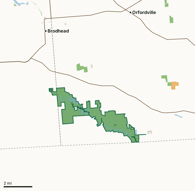
State wildlife areas, forests and other DNR landOther county, city and regional landVoluntary Public Access landAvon Bottoms Wildlife AreaCounty lineLakeHighway
| Size | 4,340 acres in 3 pieces |
|---|---|
| Counties | Rock County and Green County |
| Deer Management Unit | Rock County, Green County |
| DNR lists for hunting | deer, wild turkey, pheasants, ducks and geese and small game |
| Public access (DNR) | Open to Hiking, Fishing, Hunting and Trapping |
| DNR property page | Avon Bottoms Wildlife Area |
| Nearest towns | Brodhead (4 mi), Orfordville (7 mi) and Juda (7 mi) |
What is Avon Bottoms Wildlife Area like?
Avon Bottoms Wildlife Area is located in the town of Avon in southwest Rock County. It has gained appreciation for its wild nature since being located near more prominent Wisconsin and Illinois population centers. The property currently consists of 4,356 acres of state-owned land. Early two-thirds of this acreage is bottomland hardwood forest and wetland; the remaining third is restored native prairie and oak woodland. Documented as one of the few places in Wisconsin, sycamore trees are thriving very well here (a species typically found more to the south). Surrounding the many sloughs and oxbows, the property also includes 2 embedded State Natural Areas (SNAs) set aside for their rare intact plant communities: Swenson Wet Prairie SNA (No. 64), and Avon Bottoms SNA (No. 36).
The property provides public access for hunting, fishing, trapping, hiking, and other nature-based outdoor activities. Roughly 15 miles of the Sugar River meander through the property, and users can take a river trip from Avon down to the Sugar River Forest Preserve in Winnebago County, IL. Common game species include pheasants, turkeys, waterfowl, deer, and other small game. Avon Bottoms Wildlife Area began in 1960 as a Federal Aid in Fish and Wildlife Restoration project to provide public hunting and serve as a duck and pheasant production area. In Wisconsin's Wildlife Action Plan, it is identified as a Conservation Opportunity Area of state significance for the conservation of floodplain forest communities in Wisconsin's Wildlife Action Plan.
In the DNR's words, from its page for the property.
What can you hunt on Avon Bottoms Wildlife Area?
The DNR's page for Avon Bottoms Wildlife Area names deer, wild turkey, pheasants, ducks and geese and small game. Each follows Wisconsin's statewide season and, for deer, the tags and rules of the deer management unit.
What are the rules on Avon Bottoms Wildlife Area?
The DNR's property map lists Avon Bottoms Wildlife Area as "Open to Hiking, Fishing, Hunting and Trapping". Hunting follows Wisconsin's statewide seasons and the rules posted on the property.
Activities the DNR lists for Avon Bottoms Wildlife Area: Biking, Birding (designated Wisconsin Important Bird Area), Boating (motorized and non-motorized), Canoeing (Sugar River, put-in Avon to take out Sugar River Forest Preserve in Winnebago County, Illinois), Cross-country skiing (no designated trail), Fishing, Hiking (no designated trail), Hunting (noted for: waterfowl, turkey, deer, small game and stocked pheasant), Kayaking, Trapping, Wild edibles/gathering and Wildlife viewing.
How many deer are taken around Avon Bottoms Wildlife Area?
Avon Bottoms Wildlife Area lies in 2 deer management units. The DNR registered 2,667 deer in Rock County in 2025, against 2,501 in 2024.
| DMU | Avon Bottoms Wildlife Area acres in it | Deer, 2025 | Deer, 2024 | Deer, 2023 |
|---|---|---|---|---|
| Rock County | 4,256 | 2,667 | 2,501 | 2,468 |
| Green County | 84 | 2,562 | 2,369 | 2,830 |
Harvest for the whole deer management unit, not the property alone: Wisconsin DNR Deer Metrics (registered harvest by deer management unit).
How do you get to Avon Bottoms Wildlife Area?
Nearest towns: Brodhead (4 miles), Orfordville (7 miles), Juda (7 miles) and Hanover (9 miles). Highways within 5 miles: WI 81 and WI 11.
What other public land is near Avon Bottoms Wildlife Area?
DNR properties within 10 miles:
- Sugar River State Trail: 248 acres, 4.3 miles away
- Footville Wildlife Area: 476 acres, 7.1 miles away
- Green Co Prairies (Mural Bluff Prairie) SNA: 69 acres, 9.9 miles away
Public land within 3 miles of Avon Bottoms Wildlife Area
Counting Avon Bottoms Wildlife Area itself, 4,593 of the 57,235 acres within 3 miles of its boundary are public land open to the public (8%), by USGS PAD-US 4.1 (fee land open to the public).
| Manager | Acres within 3 miles |
|---|---|
| State wildlife areas, forests and other DNR land | 4,529 |
| Other county, city and regional land | 64 |
Questions hunters ask
Where is Avon Bottoms Wildlife Area?
In Rock and Green counties, 4 miles from Brodhead. The DNR's property page has its maps and parking.
Is Avon Bottoms Wildlife Area open to hunting?
Yes. The DNR's property map lists it as "Open to Hiking, Fishing, Hunting and Trapping". Posted refuges or closed areas, where there are any, are marked on site.
Which deer management unit is Avon Bottoms Wildlife Area in?
Rock County (4,256 acres) and Green County (84 acres).
How much public land is around Avon Bottoms Wildlife Area?
4,593 acres within 3 miles of its boundary, Avon Bottoms Wildlife Area included, by PAD-US 4.1. The closest other DNR property is Sugar River State Trail (4.3 miles).
Get a Wisconsin hunt plan when they open
Hunt plans for Wisconsin are coming. Join the list and you'll hear first. The first 50 hunters in each new state get their plan free.
Until then, the free FilledTag app for iPhone has a map that works in every state, Wisconsin included.
Where these facts come from
- Area description, species, rules and directions: DNR, Avon Bottoms Wildlife Area; Wisconsin DNR managed lands open to hunting.
- Boundary and acres: the DNR's map layer above. Surrounding public land: USGS PAD-US 4.1 (fee land open to the public).
- Deer harvest: Wisconsin DNR Deer Metrics (registered harvest by deer management unit).
FilledTag is not part of the Wisconsin Department of Natural Resources. Check the DNR's rules and posted signs before you go.
Wisconsin hunting Rock County Green County Rock County Green County