Baileys Harbor Boreal Forest and Wetlands State Natural Area: hunting and access
Baileys Harbor Boreal Forest and Wetlands State Natural Area is 616 acres of land managed by the Wisconsin DNR in Door County, 3 miles from Baileys Harbor. Hunters registered 4,302 deer in Door County in 2025.
Data updated October 2026. Area facts: the DNR's DNR property data, read 2026-10. Harvest: DNR Deer Metrics.
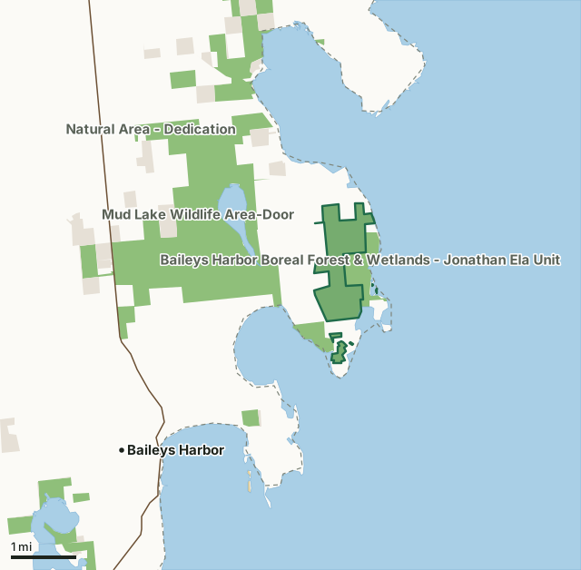
State wildlife areas, forests and other DNR landOther federal landLand trusts and other open landBaileys Harbor Boreal Forest and Wetlands State Natural AreaCounty lineLakeHighway
| Size | 616 acres in 6 pieces |
|---|---|
| County | Door County |
| Deer Management Unit | Door County |
| Public access (DNR) | Open to Hiking, Fishing, Hunting and Trapping |
| DNR property page | Baileys Harbor Boreal Forest And Wetlands |
| Nearest towns | Baileys Harbor (3 mi), Sister Bay (6 mi) and Ephraim (6 mi) |
What is Baileys Harbor Boreal Forest and Wetlands State Natural Area like?
Baileys Harbor Boreal Forest and Wetlands contains a unique and diverse landscape, influenced by the local climate along the northeastern coast of the Door Peninsula. Cooler springs and summers, warmer falls and winters, and reduced evaporation rates have allowed northern species and a boreal forest to thrive here, far south of their normal range. Balsam fir and white spruce dominate the forest, which grades into northern wet-mesic forests of white cedar, white pine, paper birch, and hemlock. Many orchids and rare plants find refuge in the forest. The natural area protects over 1.5 miles of undeveloped Lake Michigan shoreline. An extensive alkaline rock shore, or bedrock beach, is exposed during periods of low lake levels. Uncommon plants thrive on the open dolomite flats.
Door County. T30N-R28E, Sections 2, 11, 14. T31N-R28E, Section 35. 846 acres. From the intersection of State Highway 57 and County Highway Q north of Baileys Harbor, go northeast on Q for 3.4 miles, then south (right) on West Cana Island Road for 1 mile, then east on East Cana Island Road 0.9 miles to DNR parking lot north of the road. Undesignated footpaths lead north into the natural area. Or continue east on East Cana Island Road 0.24 miles, then north on Cana Cove Road 0.3 miles to a cul-de-sac. Park and walk north into the natural area. High lake levels may make access from the cul-de-sac a challenge. Alternatively, from the Highway 57/County Q intersection, go northeast on Q 4.4 miles to a gated DNR access lane marked with a State Natural Area sign east of the road and just south of Birch Road (45.112916, -87.068457).
In the DNR's words, from its page for the property.
What are the rules on Baileys Harbor Boreal Forest and Wetlands State Natural Area?
The DNR's property map lists Baileys Harbor Boreal Forest and Wetlands State Natural Area as "Open to Hiking, Fishing, Hunting and Trapping". Hunting follows Wisconsin's statewide seasons and the rules posted on the property.
How many deer are taken around Baileys Harbor Boreal Forest and Wetlands State Natural Area?
Baileys Harbor Boreal Forest and Wetlands State Natural Area lies in Door County. The DNR registered 4,302 deer in Door County in 2025, against 4,225 in 2024.
| DMU | Baileys Harbor Boreal Forest and Wetlands State Natural Area acres in it | Deer, 2025 | Deer, 2024 | Deer, 2023 |
|---|---|---|---|---|
| Door County | 616 | 4,302 | 4,225 | 3,793 |
Harvest for the whole deer management unit, not the property alone: Wisconsin DNR Deer Metrics (registered harvest by deer management unit).
How do you get to Baileys Harbor Boreal Forest and Wetlands State Natural Area?
Nearest towns: Baileys Harbor (3 miles), Sister Bay (6 miles), Ephraim (6 miles) and Ellison Bay (10 miles). Highways within 5 miles: WI 57.
What other public land is near Baileys Harbor Boreal Forest and Wetlands State Natural Area?
DNR properties within 10 miles:
- Moonlight Bay Bedrock Beach State Natural Area: 102 acres, next to it
- Baileys Harbor Boreal Forest & Wetlands - Jonathan Ela Unit: 210 acres, next to it
- Mud Lake Wildlife Area-Door: 2,434 acres, 0.5 miles away
- Peninsula State Park: 3,702 acres, 6.1 miles away
- Newport State Park: 2,467 acres, 7 miles away
Public land within 3 miles of Baileys Harbor Boreal Forest and Wetlands State Natural Area
Counting Baileys Harbor Boreal Forest and Wetlands State Natural Area itself, 4,387 of the 30,472 acres within 3 miles of its boundary are public land open to the public (14.4%), by USGS PAD-US 4.1 (fee land open to the public).
| Manager | Acres within 3 miles |
|---|---|
| State wildlife areas, forests and other DNR land | 3,998 |
| Land trusts and other open land | 381 |
| Other federal land | 8 |
Questions hunters ask
Where is Baileys Harbor Boreal Forest and Wetlands State Natural Area?
In Door County, 3 miles from Baileys Harbor. The DNR's property page has its maps and parking.
Is Baileys Harbor Boreal Forest and Wetlands State Natural Area open to hunting?
Yes. The DNR's property map lists it as "Open to Hiking, Fishing, Hunting and Trapping". Posted refuges or closed areas, where there are any, are marked on site.
Which deer management unit is Baileys Harbor Boreal Forest and Wetlands State Natural Area in?
Door County.
How much public land is around Baileys Harbor Boreal Forest and Wetlands State Natural Area?
4,387 acres within 3 miles of its boundary, Baileys Harbor Boreal Forest and Wetlands State Natural Area included, by PAD-US 4.1. The closest other DNR property is Moonlight Bay Bedrock Beach State Natural Area (next to it).
Get a Wisconsin hunt plan when they open
Hunt plans for Wisconsin are coming. Join the list and you'll hear first. The first 50 hunters in each new state get their plan free.
Until then, the free FilledTag app for iPhone has a map that works in every state, Wisconsin included.
Where these facts come from
- Area description, species, rules and directions: DNR, Baileys Harbor Boreal Forest and Wetlands State Natural Area; Wisconsin DNR managed lands open to hunting.
- Boundary and acres: the DNR's map layer above. Surrounding public land: USGS PAD-US 4.1 (fee land open to the public).
- Deer harvest: Wisconsin DNR Deer Metrics (registered harvest by deer management unit).
FilledTag is not part of the Wisconsin Department of Natural Resources. Check the DNR's rules and posted signs before you go.