Balsam Branch Wildlife Area: hunting and access
Balsam Branch Wildlife Area is 174 acres of land managed by the Wisconsin DNR in Polk County, 6 miles from Amery. The DNR's page for it names deer, wild turkey and pheasants among the game here. Hunters registered 8,091 deer in Polk County in 2025.
Data updated October 2026. Area facts: the DNR's DNR property data, read 2026-10. Harvest: DNR Deer Metrics.
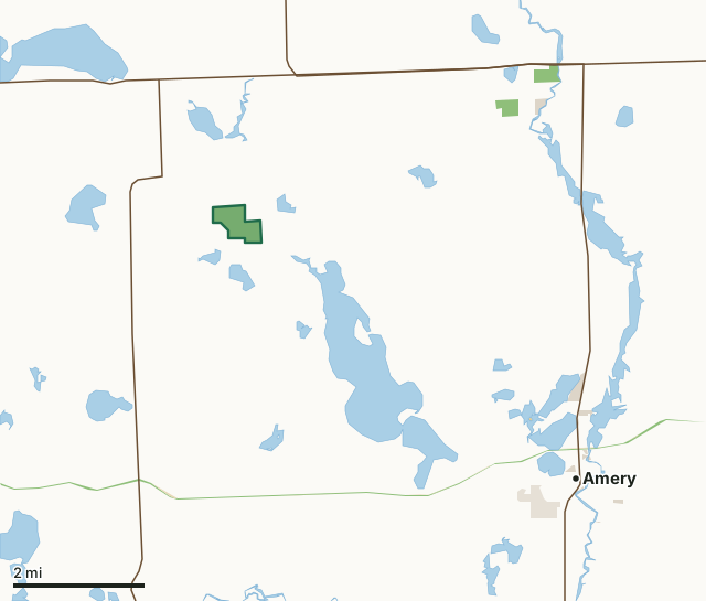
State wildlife areas, forests and other DNR landOther federal landState parksOther county, city and regional landLand trusts and other open landBalsam Branch Wildlife AreaCounty lineLakeHighway
| Size | 174 acres |
|---|---|
| County | Polk County |
| Deer Management Unit | Polk County |
| DNR lists for hunting | deer, wild turkey and pheasants |
| Public access (DNR) | Open to Hiking, Fishing, Hunting and Trapping |
| DNR property page | Balsam Branch Wildlife Area |
| Nearest towns | Amery (6 mi), Balsam Lake (7 mi) and Centuria (7 mi) |
What is Balsam Branch Wildlife Area like?
Balsam Branch Wildlife Area is a 180-acre parcel in Polk County. It features a 20-acre lake surrounded by extensive cattail, sedge and other wetland vegetation. The lake's outlet ties into the Balsam Branch and eventually leads to Lake Wapogasset. The uplands of the property are mostly forested but also contain an 8-acre prairie and scattered oak savannas. The property features two walk-in boat access points from the North and South parking lots. Find the property by following Highway 8 east of St. Croix Falls for 5.5 miles. Turn south on Highway 65 and go 1.5 miles. Turn east on 115th Avenue and go one mile. Turn south on 150th Street and go 1/2 mile to parking area. There is also a parking area on the south end of the property from Highway C.
The property was donated to the state of Wisconsin in 1967 by the American Game Association of New York. The project was developed to protect a very nice, small, unnamed lake and to provide wildlife habitat for hunting and enjoyment in Polk County. A plaque recognizing this donation is attached to a large rock on the south end of the parking lot, on the north end of the property. Management actions benefit turkey, waterfowl and deer, but pheasant and other wildlife are also found on the property. Past management includes native prairie plantings and brush management. The property is regularly maintained for invasive species. Today, prescribed burns and mowing are used to maintain the grass prairie. Balsam Branch Wildlife Area offers many recreational opportunities:.
In the DNR's words, from its page for the property.
What can you hunt on Balsam Branch Wildlife Area?
The DNR's page for Balsam Branch Wildlife Area names deer, wild turkey and pheasants. Each follows Wisconsin's statewide season and, for deer, the tags and rules of the deer management unit.
What are the rules on Balsam Branch Wildlife Area?
The DNR's property map lists Balsam Branch Wildlife Area as "Open to Hiking, Fishing, Hunting and Trapping". Hunting follows Wisconsin's statewide seasons and the rules posted on the property.
Activities the DNR lists for Balsam Branch Wildlife Area: Birding, Boating (motorized and non-motorized, walk-in access only), Canoeing, Cross-country skiing (no designated trail), Fishing, Hiking (no designated trail), Horseback riding, Hunting (noted for deer, pheasant and turkey), Trapping, Snowmobiling trail, Wild edibles/gathering and Wildlife viewing.
How many deer are taken around Balsam Branch Wildlife Area?
Balsam Branch Wildlife Area lies in Polk County. The DNR registered 8,091 deer in Polk County in 2025, against 7,972 in 2024.
| DMU | Balsam Branch Wildlife Area acres in it | Deer, 2025 | Deer, 2024 | Deer, 2023 |
|---|---|---|---|---|
| Polk County | 174 | 8,091 | 7,972 | 7,275 |
Harvest for the whole deer management unit, not the property alone: Wisconsin DNR Deer Metrics (registered harvest by deer management unit).
How do you get to Balsam Branch Wildlife Area?
Nearest towns: Amery (6 miles), Balsam Lake (7 miles), Centuria (7 miles) and Dresser (8 miles). Highways within 5 miles: US 8, WI 65, WI 46 and WI 35.
What other public land is near Balsam Branch Wildlife Area?
DNR properties within 10 miles:
- Stower Seven Lakes State Trail: 158 acres, 3.9 miles away
- Omer Springs Fishery Area: 47 acres, 4 miles away
- Behning Creek Fishery Area: 131 acres, 4.7 miles away
- Apple River Timber Demo Forest: 54 acres, 4.7 miles away
- Cattail State Trail: 241 acres, 5.9 miles away
Public land within 3 miles of Balsam Branch Wildlife Area
Counting Balsam Branch Wildlife Area itself, 176 of the 22,602 acres within 3 miles of its boundary are public land open to the public (0.8%), by USGS PAD-US 4.1 (fee land open to the public).
| Manager | Acres within 3 miles |
|---|---|
| State wildlife areas, forests and other DNR land | 175 |
| Other federal land | 1 |
Questions hunters ask
Where is Balsam Branch Wildlife Area?
In Polk County, 6 miles from Amery. The DNR's property page has its maps and parking.
Is Balsam Branch Wildlife Area open to hunting?
Yes. The DNR's property map lists it as "Open to Hiking, Fishing, Hunting and Trapping". Posted refuges or closed areas, where there are any, are marked on site.
Which deer management unit is Balsam Branch Wildlife Area in?
Polk County.
How much public land is around Balsam Branch Wildlife Area?
176 acres within 3 miles of its boundary, Balsam Branch Wildlife Area included, by PAD-US 4.1. The closest other DNR property is Stower Seven Lakes State Trail (3.9 miles).
Get a Wisconsin hunt plan when they open
Hunt plans for Wisconsin are coming. Join the list and you'll hear first. The first 50 hunters in each new state get their plan free.
Until then, the free FilledTag app for iPhone has a map that works in every state, Wisconsin included.
Where these facts come from
- Area description, species, rules and directions: DNR, Balsam Branch Wildlife Area; Wisconsin DNR managed lands open to hunting.
- Boundary and acres: the DNR's map layer above. Surrounding public land: USGS PAD-US 4.1 (fee land open to the public).
- Deer harvest: Wisconsin DNR Deer Metrics (registered harvest by deer management unit).
FilledTag is not part of the Wisconsin Department of Natural Resources. Check the DNR's rules and posted signs before you go.