Bass Hollow State Natural Area: hunting and access
Bass Hollow State Natural Area is 210 acres of land managed by the Wisconsin DNR in Juneau County, 6 miles from Lyndon Station. Hunters registered 4,295 deer in DMU Juneau in 2025.
Data updated October 2026. Area facts: the DNR's DNR property data, read 2026-10. Harvest: DNR Deer Metrics.
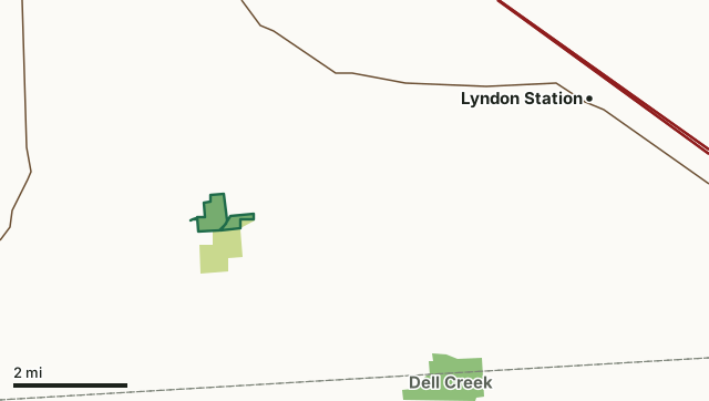
State wildlife areas, forests and other DNR landCounty forestBass Hollow State Natural AreaCounty lineHighway
| Size | 210 acres in 3 pieces |
|---|---|
| County | Juneau County |
| Deer Management Unit | DMU Juneau |
| Public access (DNR) | Open to Hiking, Fishing, Hunting and Trapping |
| DNR property page | Bass Hollow |
| Nearest towns | Lyndon Station (6 mi), Mauston (8 mi) and La Valle (8 mi) |
What is Bass Hollow State Natural Area like?
Located in a deep, cliff-lined coulee, Bass Hollow contains an undisturbed, forested gorge of mesic hardwoods with sugar maple, basswood and red oak. Other trees include yellow birch and black ash found in springy areas. Hemlock occupies north-facing cliffs. This site features one of the largest blocks of undisturbed southern mesic forest in the state. The topography is very steep with sandstone cliffs rising over 100 feet high in some places. The upper slopes and ridge tops support a dry to the dry-mesic forest of red and white oaks, big-tooth aspen and black cherry. The ground layer is diverse and contains herbaceous plants such as doll's eyes, blue cohosh, wild geranium, hepaticas, early meadow rue, mayapple, sweet cicely, lady fern, fragile fern and silvery spleenwort. Bass Hollow is owned by the DNR and was designated a State Natural Area in 1999.
Entrance fees : Excepting Parfrey's Glen, Pewits Nest, the Dells of the Wisconsin River, SNAs within State Parks and some within State Forests, all other DNR-owned SNAs do not have any admission fees. Admin. Code NR 45. Juneau County. T14N-R4E, Sections 16, 21. 212 acres. Highway 12 and State Highway 58 in Mauston, go southeast on 12 1.9 miles, then south on County Highway K for 7.1 miles, then east on Cowan Road for about 0.7 miles. The natural area lies northwest and southeast of the road. Or continue on K 0.5 mile past Cowan Road to a parking area for Bass Hollow Recreational Area. Bass Hollow is owned by the Wisconsin DNR.
In the DNR's words, from its page for the property.
What are the rules on Bass Hollow State Natural Area?
The DNR's property map lists Bass Hollow State Natural Area as "Open to Hiking, Fishing, Hunting and Trapping". Hunting follows Wisconsin's statewide seasons and the rules posted on the property.
How many deer are taken around Bass Hollow State Natural Area?
Bass Hollow State Natural Area lies in DMU Juneau. The DNR registered 4,295 deer in DMU Juneau in 2025.
| DMU | Bass Hollow State Natural Area acres in it | Deer, 2025 |
|---|---|---|
| DMU Juneau | 210 | 4,295 |
Harvest for the whole deer management unit, not the property alone: Wisconsin DNR Deer Metrics (registered harvest by deer management unit).
How do you get to Bass Hollow State Natural Area?
Nearest towns: Lyndon Station (6 miles), Mauston (8 miles), La Valle (8 miles) and Wonewoc (10 miles). Highways within 5 miles: WI 58 and US 12.
What other public land is near Bass Hollow State Natural Area?
DNR properties within 10 miles:
- Dell Creek Wildlife Area: 2,710 acres, 3.9 miles away
- Onemile Creek SBE Area: 285 acres, 5.8 miles away
- The 400 State Trail: 359 acres, 7.5 miles away
- Hulburt Creek Fishery Area: 573 acres, 8.9 miles away
- Lemonweir Bottomland Hardwood Forest SNA: 322 acres, 9.1 miles away
- Brewer Creek-Lemonweir River SHA: 24 acres, 9.2 miles away
Public land within 3 miles of Bass Hollow State Natural Area
Counting Bass Hollow State Natural Area itself, 504 of the 23,749 acres within 3 miles of its boundary are public land open to the public (2.1%), by USGS PAD-US 4.1 (fee land open to the public).
| Manager | Acres within 3 miles |
|---|---|
| County forest | 289 |
| State wildlife areas, forests and other DNR land | 215 |
Questions hunters ask
Where is Bass Hollow State Natural Area?
In Juneau County, 6 miles from Lyndon Station. The DNR's property page has its maps and parking.
Is Bass Hollow State Natural Area open to hunting?
Yes. The DNR's property map lists it as "Open to Hiking, Fishing, Hunting and Trapping". Posted refuges or closed areas, where there are any, are marked on site.
Which deer management unit is Bass Hollow State Natural Area in?
DMU Juneau.
How much public land is around Bass Hollow State Natural Area?
504 acres within 3 miles of its boundary, Bass Hollow State Natural Area included, by PAD-US 4.1. The closest other DNR property is Dell Creek Wildlife Area (3.9 miles).
Get a Wisconsin hunt plan when they open
Hunt plans for Wisconsin are coming. Join the list and you'll hear first. The first 50 hunters in each new state get their plan free.
Until then, the free FilledTag app for iPhone has a map that works in every state, Wisconsin included.
Where these facts come from
- Area description, species, rules and directions: DNR, Bass Hollow State Natural Area; Wisconsin DNR managed lands open to hunting.
- Boundary and acres: the DNR's map layer above. Surrounding public land: USGS PAD-US 4.1 (fee land open to the public).
- Deer harvest: Wisconsin DNR Deer Metrics (registered harvest by deer management unit).
FilledTag is not part of the Wisconsin Department of Natural Resources. Check the DNR's rules and posted signs before you go.