Big Muskego Lake Wildlife Area: hunting and access
Big Muskego Lake Wildlife Area is 1,109 acres of land managed by the Wisconsin DNR in Waukesha and Milwaukee counties, next to Wind Lake. Hunters registered 3,320 deer in Waukesha County in 2025.
Data updated October 2026. Area facts: the DNR's DNR property data, read 2026-10. Harvest: DNR Deer Metrics.
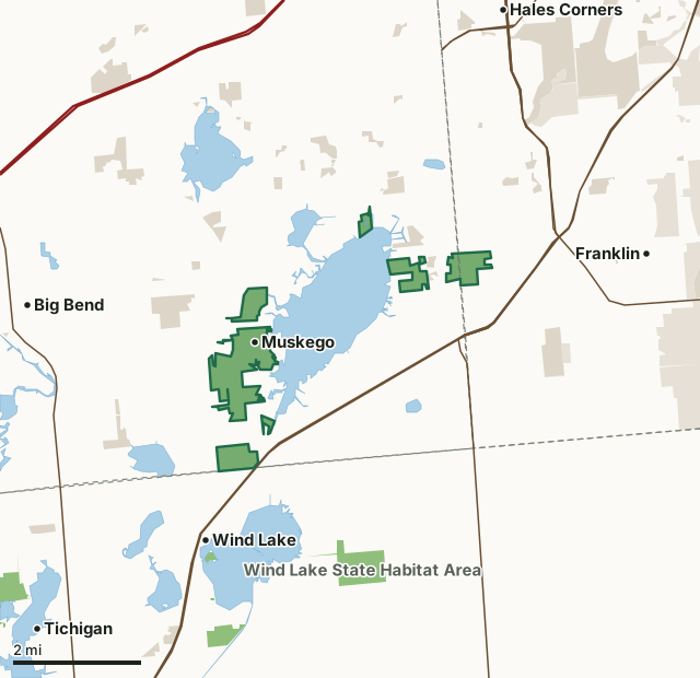
State wildlife areas, forests and other DNR landOther county, city and regional landLand trusts and other open landBig Muskego Lake Wildlife AreaCounty lineLakeHighway
| Size | 1,109 acres in 8 pieces |
|---|---|
| Counties | Waukesha County and Milwaukee County |
| Deer Management Unit | Waukesha County, Milwaukee County |
| Public access (DNR) | Open to Hiking, Fishing, Hunting and Trapping |
| DNR property page | Big Muskego Lake Wildlife Area |
| Nearest towns | Wind Lake (next to it), Franklin (2 mi) and Big Bend (3 mi) |
What is Big Muskego Lake Wildlife Area like?
Big Muskego Lake Wildlife Area is located in southeastern Waukesha County, with a small portion crossing into Milwaukee County. This wildlife area protects approximately 1000 acres of land around Big Muskego Lake and has about 2.5 miles of lake frontage and 0.2 miles of frontage along the Muskego Canal. The habitat of the wildlife area consists of a mix of lowland shrub, upland hardwood and oak forests, several areas with native and planted prairies, and several small emergent wetlands. The diverse wildlife area provides excellent opportunities for hunting, fishing and trapping. This property also has an approximately 160-acre waterfowl refuge on the west shore of Big Muskego Lake. This no-entry wildlife refuge is closed from September 1st through December 31st, except for gun and muzzleloader deer hunting and retrieval of legally killed or crippled game.
Big Muskego Lake Wildlife Area is located in southeastern Waukesha County, just southwest of Milwaukee. It is south of I-43 and north of State Highway 36, bordered by County Highway Y on the west and County Highway OO on the east. Several upland parcels surround the lake off Boxhorn Drive in the northeast, Muskego Dam Road in the south, and Parker Road at the east end of the lake. Following the successful rehabilitation of Big Muskego Lake in 1995-96, the Big Muskego Lake Wildlife Area was established in 1999 to protect the area surrounding this shallow lake. The city of Muskego and the DNR have partnered to preserve hundreds of acres around the lake.
In the DNR's words, from its page for the property.
What are the rules on Big Muskego Lake Wildlife Area?
The DNR's property map lists Big Muskego Lake Wildlife Area as "Open to Hiking, Fishing, Hunting and Trapping". Hunting follows Wisconsin's statewide seasons and the rules posted on the property.
Activities the DNR lists for Big Muskego Lake Wildlife Area: Birding (eagles, ospreys, forester's terns and great blue herons breed in the area), Canoeing, Cross-country skiing (no designated trail), Fishing and Hiking (no designated trail).
How many deer are taken around Big Muskego Lake Wildlife Area?
Big Muskego Lake Wildlife Area lies in 2 deer management units. The DNR registered 3,320 deer in Waukesha County in 2025, against 3,021 in 2024.
| DMU | Big Muskego Lake Wildlife Area acres in it | Deer, 2025 | Deer, 2024 | Deer, 2023 |
|---|---|---|---|---|
| Waukesha County | 988 | 3,320 | 3,021 | 2,888 |
| Milwaukee County | 120 | 206 | 180 | 200 |
Harvest for the whole deer management unit, not the property alone: Wisconsin DNR Deer Metrics (registered harvest by deer management unit).
How do you get to Big Muskego Lake Wildlife Area?
Nearest towns: Wind Lake (next to it), Franklin (2 miles), Big Bend (3 miles) and Hales Corners (4 miles). Highways within 5 miles: WI 36, I-43, US 45, WI 100 and WI 164.
What other public land is near Big Muskego Lake Wildlife Area?
DNR properties within 10 miles:
- Wind Lake State Habitat Area: 347 acres, 1.6 miles away
- Tichigan Wildlife Area: 1,602 acres, 3.4 miles away
- Vernon Wildlife Area: 4,355 acres, 7.1 miles away
- Pebble Brook State Habitat Area: 35 acres, 7.3 miles away
- Dover State Habitat Area: 89 acres, 7.5 miles away
Public land within 3 miles of Big Muskego Lake Wildlife Area
Counting Big Muskego Lake Wildlife Area itself, 3,141 of the 47,897 acres within 3 miles of its boundary are public land open to the public (6.6%), by USGS PAD-US 4.1 (fee land open to the public).
| Manager | Acres within 3 miles |
|---|---|
| State wildlife areas, forests and other DNR land | 1,492 |
| Other county, city and regional land | 1,153 |
| Land trusts and other open land | 496 |
Questions hunters ask
Where is Big Muskego Lake Wildlife Area?
In Waukesha and Milwaukee counties, next to Wind Lake. The DNR's property page has its maps and parking.
Is Big Muskego Lake Wildlife Area open to hunting?
Yes. The DNR's property map lists it as "Open to Hiking, Fishing, Hunting and Trapping". Posted refuges or closed areas, where there are any, are marked on site.
Which deer management unit is Big Muskego Lake Wildlife Area in?
Waukesha County (988 acres) and Milwaukee County (120 acres).
How much public land is around Big Muskego Lake Wildlife Area?
3,141 acres within 3 miles of its boundary, Big Muskego Lake Wildlife Area included, by PAD-US 4.1. The closest other DNR property is Wind Lake State Habitat Area (1.6 miles).
Get a Wisconsin hunt plan when they open
Hunt plans for Wisconsin are coming. Join the list and you'll hear first. The first 50 hunters in each new state get their plan free.
Until then, the free FilledTag app for iPhone has a map that works in every state, Wisconsin included.
Where these facts come from
- Area description, species, rules and directions: DNR, Big Muskego Lake Wildlife Area; Wisconsin DNR managed lands open to hunting.
- Boundary and acres: the DNR's map layer above. Surrounding public land: USGS PAD-US 4.1 (fee land open to the public).
- Deer harvest: Wisconsin DNR Deer Metrics (registered harvest by deer management unit).
FilledTag is not part of the Wisconsin Department of Natural Resources. Check the DNR's rules and posted signs before you go.
Wisconsin hunting Waukesha County Milwaukee County Waukesha County Milwaukee County