Bill Cross Wildlife Area: hunting and access
Bill Cross Wildlife Area is 1,522 acres of land managed by the Wisconsin DNR in Lincoln County, 6 miles from Merrill. Hunters registered 2,516 deer in DMU 119 in 2025.
Data updated October 2026. Area facts: the DNR's DNR property data, read 2026-10. Harvest: DNR Deer Metrics.
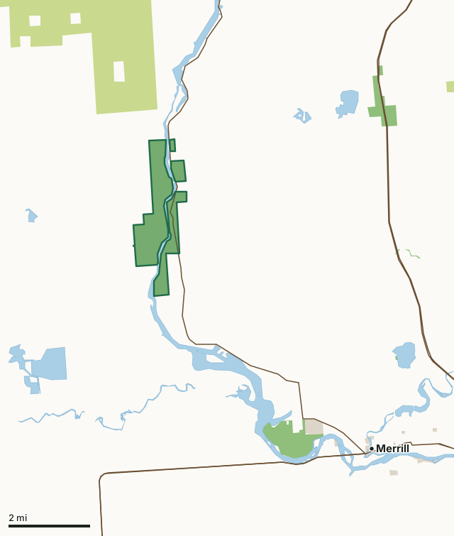
State wildlife areas, forests and other DNR landCounty forestOther federal landOther county, city and regional landBill Cross Wildlife AreaCounty lineLakeHighway
| Size | 1,522 acres in 4 pieces |
|---|---|
| County | Lincoln County |
| Deer Management Unit | DMU 119 |
| Public access (DNR) | Open to Hiking, Fishing, Hunting and Trapping |
| DNR property page | Bill Cross Wildlife Area |
| Nearest towns | Merrill (6 mi), Tomahawk (13 mi) and Maine (14 mi) |
What is Bill Cross Wildlife Area like?
The property encompasses 3 3/4 miles of Wisconsin River frontage and is mostly undeveloped with forested uplands adjoining the river. The east-facing river bank tends to be steep, dropping some 100 feet in elevation to the river's edge. The dominant habitat types are aspen and northern hardwood forests. Several pine plantations are present within the property. Small kettle wetlands are scattered on the property west of the river. Wetland types include open water with emergent wet meadows or river meander scars with forested and emergent wetland types and shrub-carr. The property is approximately 8 miles northwest of the city of Merrill and can be accessed on the east side of the Wisconsin River from Highway 107 or the west side of the Wisconsin River from Tesch Road.
Unpublished writings by a local historian named George Gilkey, on or about 1970, documented that William Henry Harrison Cross operated a fur trading post with Martin Lynch for Hudson Bay Trading Co. at the mouth of the New Wood River (just below the rapids) in the early 1800s. The ruins of the old post run by Cross and Lynch at the mouth of the New Wood River were visible as late as the 1930s. Bill Cross homesteaded for many years on the east bank of the Wisconsin River, where an old military tote road crossed the river - hence, the name of the rapids today. The Bill Cross Wildlife Area is managed to provide opportunities for public hunting, trapping, fishing and other outdoor recreation while protecting the qualities of the unique native communities and associated species found on the property.
In the DNR's words, from its page for the property.
What are the rules on Bill Cross Wildlife Area?
The DNR's property map lists Bill Cross Wildlife Area as "Open to Hiking, Fishing, Hunting and Trapping". Hunting follows Wisconsin's statewide seasons and the rules posted on the property.
Activities the DNR lists for Bill Cross Wildlife Area: Birding, Boating (motorized), Boating (non-motorized), Canoeing, Cross-country skiing (no designated trail), Fishing, Hiking (no designated trail), Hunting, Kayaking, Snowmobiling (on designated trail only), Swimming, Trapping, Wild edibles/gathering and Wildlife viewing.
How many deer are taken around Bill Cross Wildlife Area?
Bill Cross Wildlife Area lies in DMU 119. The DNR registered 2,516 deer in DMU 119 in 2025.
| DMU | Bill Cross Wildlife Area acres in it | Deer, 2025 |
|---|---|---|
| DMU 119 | 1,522 | 2,516 |
Harvest for the whole deer management unit, not the property alone: Wisconsin DNR Deer Metrics (registered harvest by deer management unit).
How do you get to Bill Cross Wildlife Area?
Nearest towns: Merrill (6 miles), Tomahawk (13 miles), Maine (14 miles) and Rib Lake (19 miles). Highways within 5 miles: WI 107, WI 64 and US 51.
What other public land is near Bill Cross Wildlife Area?
DNR properties within 10 miles:
- Tomahawk Timberlands Conservation Easement (New Wood Trct): 16,945 acres, 3.5 miles away
- Council Grounds State Park: 494 acres, 3.9 miles away
- Parallel Ridges State Ice Age Trail Area: 65 acres, 4.9 miles away
- New Wood Wildlife Area: 2,704 acres, 5.6 miles away
- Prairie River Fishery Area: 2,622 acres, 7.2 miles away
Public land within 3 miles of Bill Cross Wildlife Area
Counting Bill Cross Wildlife Area itself, 3,553 of the 37,310 acres within 3 miles of its boundary are public land open to the public (9.5%), by USGS PAD-US 4.1 (fee land open to the public).
| Manager | Acres within 3 miles |
|---|---|
| County forest | 2,019 |
| State wildlife areas, forests and other DNR land | 1,531 |
| Other federal land | 3 |
Questions hunters ask
Where is Bill Cross Wildlife Area?
In Lincoln County, 6 miles from Merrill. The DNR's property page has its maps and parking.
Is Bill Cross Wildlife Area open to hunting?
Yes. The DNR's property map lists it as "Open to Hiking, Fishing, Hunting and Trapping". Posted refuges or closed areas, where there are any, are marked on site.
Which deer management unit is Bill Cross Wildlife Area in?
DMU 119.
How much public land is around Bill Cross Wildlife Area?
3,553 acres within 3 miles of its boundary, Bill Cross Wildlife Area included, by PAD-US 4.1. The closest other DNR property is Tomahawk Timberlands Conservation Easement (New Wood Trct) (3.5 miles).
Get a Wisconsin hunt plan when they open
Hunt plans for Wisconsin are coming. Join the list and you'll hear first. The first 50 hunters in each new state get their plan free.
Until then, the free FilledTag app for iPhone has a map that works in every state, Wisconsin included.
Where these facts come from
- Area description, species, rules and directions: DNR, Bill Cross Wildlife Area; Wisconsin DNR managed lands open to hunting.
- Boundary and acres: the DNR's map layer above. Surrounding public land: USGS PAD-US 4.1 (fee land open to the public).
- Deer harvest: Wisconsin DNR Deer Metrics (registered harvest by deer management unit).
FilledTag is not part of the Wisconsin Department of Natural Resources. Check the DNR's rules and posted signs before you go.