Black Earth Creek Fishery Area: hunting and access
Black Earth Creek Fishery Area is 441 acres of land managed by the Wisconsin DNR in Dane County, next to Cross Plains. Hunters registered 4,438 deer in Dane County in 2025.
Data updated October 2026. Area facts: the DNR's DNR property data, read 2026-10. Harvest: DNR Deer Metrics.
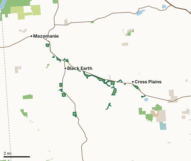
State wildlife areas, forests and other DNR landCounty forestNational wildlife refuges and waterfowl production areasNational park landOther county, city and regional landBlack Earth Creek Fishery AreaCounty lineLakeHighway
| Size | 441 acres in 27 pieces |
|---|---|
| County | Dane County |
| Deer Management Unit | Dane County |
| Public access (DNR) | Open to Hiking, Fishing, Hunting and Trapping |
| DNR property page | Black Earth Creek Fishery Area |
| Nearest towns | Cross Plains (next to it), Black Earth (next to it) and Mazomanie (next to it) |
What is Black Earth Creek Fishery Area like?
Black Earth Creek Fishery Area is a pleasant mix of a high-quality trout stream flowing within a wide green agricultural valley. The parcels typically mix stream stretches with adjoining riparian corridors that grade from a wet margin of jewelweed, aster, and reed canary grass into shrub, then sparse woodlot, then pasture or cultivated crop. The corridor alternates from open to partially canopied. There are small pockets of low-lying sedge and wetland. The stream is a class 1 coldwater fishery characterized by high gradient, coarse substrates, with much meandering and pleasant riffle-pool sequences. Recognized as a premier trout destination and regionally significant and unique resource, much attention has focused here.
The Black Earth Creek Fishery Area follows both the north and south banks of Black Earth Creek, beginning west of Middleton and proceeding westward to east of Black Earth in Dane County. Access to the stream and adjacent lands is from US Hwy 14 and town roads and County Hwy KP. Multiple road accessible entry points are well marked with either yellow standards, signage, and, where possible, parking areas. The creek is designated as a class 1 trout stream and, as such, receives no stocking. Note : No overnight camping or fires are allowed. Signage indicates permitted and prohibited uses. The Black Earth Creek Fishery Area is managed for stream restoration, trout habitat, and public access.
In the DNR's words, from its page for the property.
What are the rules on Black Earth Creek Fishery Area?
The DNR's property map lists Black Earth Creek Fishery Area as "Open to Hiking, Fishing, Hunting and Trapping". Hunting follows Wisconsin's statewide seasons and the rules posted on the property.
Activities the DNR lists for Black Earth Creek Fishery Area: Hunting, Trapping, Hiking (no established trails), Snowmobiling trail (on marked trails), Wildlife viewing, Fishing, Bird watching, Berry picking and Geocaching (with property manager approval).
How many deer are taken around Black Earth Creek Fishery Area?
Black Earth Creek Fishery Area lies in Dane County. The DNR registered 4,438 deer in Dane County in 2025, against 4,403 in 2024.
| DMU | Black Earth Creek Fishery Area acres in it | Deer, 2025 | Deer, 2024 | Deer, 2023 |
|---|---|---|---|---|
| Dane County | 441 | 4,438 | 4,403 | 4,461 |
Harvest for the whole deer management unit, not the property alone: Wisconsin DNR Deer Metrics (registered harvest by deer management unit).
How do you get to Black Earth Creek Fishery Area?
Nearest towns: Cross Plains (next to it), Black Earth (next to it), Mazomanie (next to it) and Mount Horeb (5 miles). Highways within 5 miles: US 14, WI 78 and WI 19.
What other public land is near Black Earth Creek Fishery Area?
DNR properties within 10 miles:
- State Ice Age Trail Area (SIATA): 4,676 acres, next to it
- Cross Plains State Park: 351 acres, 0.9 miles away
- Lower Wisconsin State Riverway: 47,767 acres, 3.1 miles away
Public land within 3 miles of Black Earth Creek Fishery Area
Counting Black Earth Creek Fishery Area itself, 2,990 of the 67,515 acres within 3 miles of its boundary are public land open to the public (4.4%), by USGS PAD-US 4.1 (fee land open to the public).
| Manager | Acres within 3 miles |
|---|---|
| State wildlife areas, forests and other DNR land | 1,106 |
| Other county, city and regional land | 1,027 |
| County forest | 528 |
| National wildlife refuges and waterfowl production areas | 172 |
| National park land | 155 |
| State parks | 2 |
Questions hunters ask
Where is Black Earth Creek Fishery Area?
In Dane County, next to Cross Plains. The DNR's property page has its maps and parking.
Is Black Earth Creek Fishery Area open to hunting?
Yes. The DNR's property map lists it as "Open to Hiking, Fishing, Hunting and Trapping". Posted refuges or closed areas, where there are any, are marked on site.
Which deer management unit is Black Earth Creek Fishery Area in?
Dane County.
How much public land is around Black Earth Creek Fishery Area?
2,990 acres within 3 miles of its boundary, Black Earth Creek Fishery Area included, by PAD-US 4.1. The closest other DNR property is State Ice Age Trail Area (SIATA) (next to it).
Get a Wisconsin hunt plan when they open
Hunt plans for Wisconsin are coming. Join the list and you'll hear first. The first 50 hunters in each new state get their plan free.
Until then, the free FilledTag app for iPhone has a map that works in every state, Wisconsin included.
Where these facts come from
- Area description, species, rules and directions: DNR, Black Earth Creek Fishery Area; Wisconsin DNR managed lands open to hunting.
- Boundary and acres: the DNR's map layer above. Surrounding public land: USGS PAD-US 4.1 (fee land open to the public).
- Deer harvest: Wisconsin DNR Deer Metrics (registered harvest by deer management unit).
FilledTag is not part of the Wisconsin Department of Natural Resources. Check the DNR's rules and posted signs before you go.