Brooklyn Wildlife Area: hunting and access
Brooklyn Wildlife Area is 2,928 acres of land managed by the Wisconsin DNR in Dane and Green counties, 2 miles from Belleville. Hunters registered 4,438 deer in Dane County in 2025.
Data updated October 2026. Area facts: the DNR's DNR property data, read 2026-10. Harvest: DNR Deer Metrics.
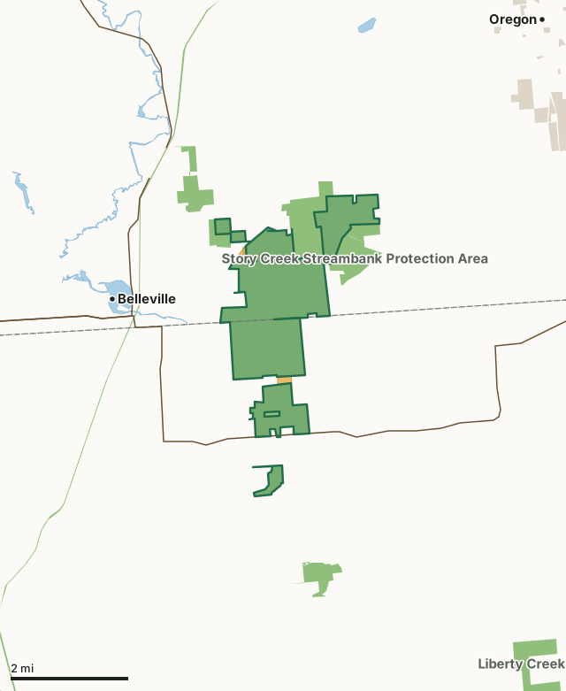
State wildlife areas, forests and other DNR landOther county, city and regional landVoluntary Public Access landBrooklyn Wildlife AreaCounty lineLakeHighway
| Size | 2,928 acres in 6 pieces |
|---|---|
| Counties | Dane County and Green County |
| Deer Management Unit | Dane County, Green County |
| Public access (DNR) | Open to Hiking, Fishing, Hunting and Trapping |
| DNR property page | Brooklyn Wildlife Area |
| Nearest towns | Belleville (2 mi), Oregon (4 mi) and Brooklyn (4 mi) |
What is Brooklyn Wildlife Area like?
Brooklyn Wildlife Area has a little bit of everything less than an hour's drive from Madison. This wildlife area is just shy of 3,000 acres of public land with a mix of wetland, prairie, oak savanna and hardwood forest. Adjacent to the state-owned land is approximately 300 acres of private farmland under conservation easement which allows for public access and is protected from development, this creates an impressive amount of acreage of undeveloped land in southern Wisconsin benefitting both wildlife and the public. Access to the property is from Dane County Highway D, 2 miles east of Belleville and off State Highway 92. Story Creek, a class 2 trout stream runs through the property offering opportunities for fishing. Story Creek Stream Bank Protection project helps protect and buffer the stream by providing funding to purchase several properties in the Brooklyn Wildlife Area as well.
Brooklyn Wildlife Area also hosts 3.5 miles of Ice Age Trail which is a popular spot to hike year-round. Friends of Brooklyn and the Dane County Chapter of the Ice Age Trail Alliance [exit DNR] are active volunteer groups helping to maintain and improve Brooklyn Wildlife Area. The acquisition of Brooklyn Wildlife Area began in 1945. Since 2004, the department has been making a concerted effort to convert annual public hunting ground leases of private lands to easements in cooperation with the USDA Natural Resources Conservation Service through the Farm and Ranch Protection Program. These easements allow public hunting and fishing in perpetuity while allowing the landowner to continue agricultural use of their land. This program depends on good hunter conduct for its success.
In the DNR's words, from its page for the property.
What are the rules on Brooklyn Wildlife Area?
The DNR's property map lists Brooklyn Wildlife Area as "Open to Hiking, Fishing, Hunting and Trapping". Hunting follows Wisconsin's statewide seasons and the rules posted on the property.
Activities the DNR lists for Brooklyn Wildlife Area: Auto travel (on public roads through and adjacent to the property), Biking (on public roads through and adjacent to the property), Birding (known for yellow-breasted chat, Bell's vireo, cerulean warbler and Henslow's sparrow), Fishing (Story Creek, a quality trout stream runs through the property), Canoeing (Story Creek, limited to small canoes during high water due to brush and logs), Hiking ( Ice Age Trail [exit DNR] runs through the property), Cross-country skiing (along the Ice Age Trail), Trapping, Wild edibles/gathering and Wildlife viewing.
How many deer are taken around Brooklyn Wildlife Area?
Brooklyn Wildlife Area lies in 2 deer management units. The DNR registered 4,438 deer in Dane County in 2025, against 4,403 in 2024.
| DMU | Brooklyn Wildlife Area acres in it | Deer, 2025 | Deer, 2024 | Deer, 2023 |
|---|---|---|---|---|
| Dane County | 1,720 | 4,438 | 4,403 | 4,461 |
| Green County | 1,207 | 2,562 | 2,369 | 2,830 |
Harvest for the whole deer management unit, not the property alone: Wisconsin DNR Deer Metrics (registered harvest by deer management unit).
How do you get to Brooklyn Wildlife Area?
Nearest towns: Belleville (2 miles), Oregon (4 miles), Brooklyn (4 miles) and Monticello (7 miles). Highways within 5 miles: WI 92, WI 69, US 14 and WI 104. 2 VPA properties within 3 miles.
What other public land is near Brooklyn Wildlife Area?
DNR properties within 10 miles:
- Story Creek Streambank Protection Area: 497 acres, next to it
- State Ice Age Trail Area (SIATA): 4,676 acres, next to it
- Badger State Trail: 523 acres, 1.3 miles away
- Liberty Creek Wildlife Area: 565 acres, 4.7 miles away
Public land within 3 miles of Brooklyn Wildlife Area
Counting Brooklyn Wildlife Area itself, 4,189 of the 48,790 acres within 3 miles of its boundary are public land open to the public (8.6%), by USGS PAD-US 4.1 (fee land open to the public).
| Manager | Acres within 3 miles |
|---|---|
| State wildlife areas, forests and other DNR land | 4,146 |
| Other county, city and regional land | 42 |
| State parks | 1 |
Questions hunters ask
Where is Brooklyn Wildlife Area?
In Dane and Green counties, 2 miles from Belleville. The DNR's property page has its maps and parking.
Is Brooklyn Wildlife Area open to hunting?
Yes. The DNR's property map lists it as "Open to Hiking, Fishing, Hunting and Trapping". Posted refuges or closed areas, where there are any, are marked on site.
Which deer management unit is Brooklyn Wildlife Area in?
Dane County (1,720 acres) and Green County (1,207 acres).
How much public land is around Brooklyn Wildlife Area?
4,189 acres within 3 miles of its boundary, Brooklyn Wildlife Area included, by PAD-US 4.1. The closest other DNR property is Story Creek Streambank Protection Area (next to it).
Get a Wisconsin hunt plan when they open
Hunt plans for Wisconsin are coming. Join the list and you'll hear first. The first 50 hunters in each new state get their plan free.
Until then, the free FilledTag app for iPhone has a map that works in every state, Wisconsin included.
Where these facts come from
- Area description, species, rules and directions: DNR, Brooklyn Wildlife Area; Wisconsin DNR managed lands open to hunting.
- Boundary and acres: the DNR's map layer above. Surrounding public land: USGS PAD-US 4.1 (fee land open to the public).
- Deer harvest: Wisconsin DNR Deer Metrics (registered harvest by deer management unit).
FilledTag is not part of the Wisconsin Department of Natural Resources. Check the DNR's rules and posted signs before you go.
Wisconsin hunting Dane County Green County Dane County Green County