Brule St Croix Legacy Forest: hunting and access
Brule St Croix Legacy Forest is 74,457 acres of land managed by the Wisconsin DNR in Douglas, Washburn, Bayfield and Burnett counties, next to Gordon. The DNR's page for it names deer, ruffed grouse and woodcock among the game here. Hunters registered 2,406 deer in DMU 107 in 2025.
Data updated October 2026. Area facts: the DNR's DNR property data, read 2026-10. Harvest: DNR Deer Metrics.
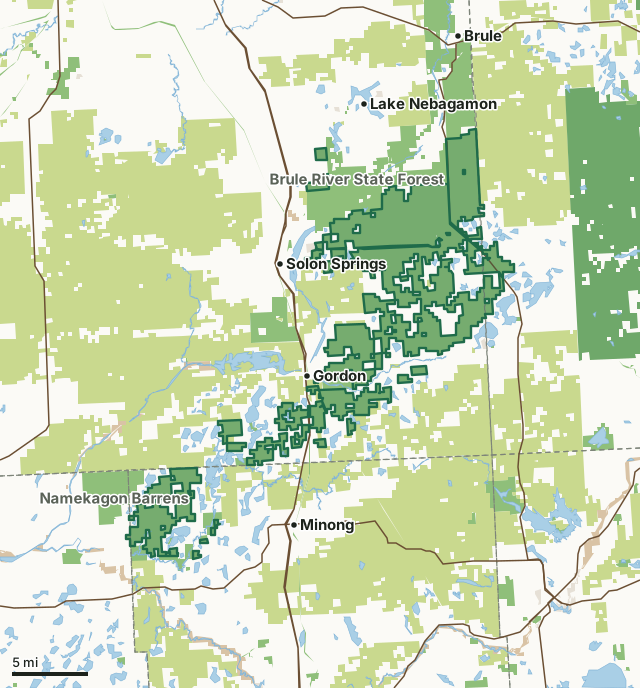
State wildlife areas, forests and other DNR landCounty forestNational forestNational park landOther county, city and regional landLand trusts and other open landBrule St Croix Legacy ForestCounty lineLakeHighway
| Size | 74,457 acres in 38 pieces |
|---|---|
| Counties | Douglas County, Washburn County, Bayfield County and Burnett County |
| Deer Management Unit | DMU 107, DMU 102 |
| DNR lists for hunting | deer, ruffed grouse and woodcock |
| Public access (DNR) | Open to Hiking, Fishing, Hunting and Trapping |
| DNR property page | Preserving Brule-St. Croix Legacy Forest |
| Nearest towns | Gordon (next to it), Solon Springs (2 mi) and Lake Nebagamon (4 mi) |
What is Brule St Croix Legacy Forest like?
Preserving Brule-St. Croix Legacy Forest Our Impact Our Projects Preserving Brule-St. Croix Legacy Forest In northern Wisconsin, The Conservation Fund preserved nearly 14 miles of tributaries and streams alongside more than 80 small lakes and ponds. jobs supported, contributing to the local economy.
Working forests define the northern Wisconsin landscape, providing timber for the state’s mills, jobs for local residents, tax revenue for local communities, habitat for wildlife, recreational opportunities for outdoor enthusiasts and clean drinking water for thousands of people. Thanks to a broad group of partners from the public and private sectors, one of northern Wisconsin’s endangered forest landscapes has been protected. We helped secure the opportunity for the Wisconsin Department of Natural Resources to purchase an easement from the Lyme Timber Company, while also helping the agency to design the conservation easement. This significant effort was made possible with funding from the federal Land and Water Conservation, through the Forest Legacy Program, and Wisconsin’s Knowles-Nelson Stewardship Program.
In the DNR's words, from its page for the property.
What can you hunt on Brule St Croix Legacy Forest?
The DNR's page for Brule St Croix Legacy Forest names deer, ruffed grouse and woodcock. Each follows Wisconsin's statewide season and, for deer, the tags and rules of the deer management unit.
What are the rules on Brule St Croix Legacy Forest?
The DNR's property map lists Brule St Croix Legacy Forest as "Open to Hiking, Fishing, Hunting and Trapping". Hunting follows Wisconsin's statewide seasons and the rules posted on the property.
How many deer are taken around Brule St Croix Legacy Forest?
Brule St Croix Legacy Forest lies in 2 deer management units. The DNR registered 2,406 deer in DMU 107 in 2025.
| DMU | Brule St Croix Legacy Forest acres in it | Deer, 2025 |
|---|---|---|
| DMU 107 | 49,371 | 2,406 |
| DMU 102 | 25,087 | 2,184 |
Harvest for the whole deer management unit, not the property alone: Wisconsin DNR Deer Metrics (registered harvest by deer management unit).
How do you get to Brule St Croix Legacy Forest?
Nearest towns: Gordon (next to it), Solon Springs (2 miles), Lake Nebagamon (4 miles) and Minong (4 miles). Highways within 5 miles: US 53, WI 27 and WI 77.
What other public land is near Brule St Croix Legacy Forest?
DNR properties within 10 miles:
- Wild Rivers State Trail: 1,158 acres, next to it
- Totogatic Wild River: 2,494 acres, next to it
- Beartrack Lake State Public Access: 26 acres, next to it
- Brule River State Forest: 47,356 acres, next to it
Public land within 3 miles of Brule St Croix Legacy Forest
Counting Brule St Croix Legacy Forest itself, 177,041 of the 337,591 acres within 3 miles of its boundary are public land open to the public (52.4%), by USGS PAD-US 4.1 (fee land open to the public).
| Manager | Acres within 3 miles |
|---|---|
| State wildlife areas, forests and other DNR land | 104,349 |
| County forest | 70,999 |
| National park land | 1,260 |
| Land trusts and other open land | 378 |
| Other county, city and regional land | 52 |
| State parks | 3 |
Questions hunters ask
Where is Brule St Croix Legacy Forest?
In Douglas, Washburn, Bayfield and Burnett counties, next to Gordon. The DNR's property page has its maps and parking.
Is Brule St Croix Legacy Forest open to hunting?
Yes. The DNR's property map lists it as "Open to Hiking, Fishing, Hunting and Trapping". Posted refuges or closed areas, where there are any, are marked on site.
Which deer management unit is Brule St Croix Legacy Forest in?
DMU 107 (49,371 acres) and DMU 102 (25,087 acres).
How much public land is around Brule St Croix Legacy Forest?
177,041 acres within 3 miles of its boundary, Brule St Croix Legacy Forest included, by PAD-US 4.1. The closest other DNR property is Wild Rivers State Trail (next to it).
Get a Wisconsin hunt plan when they open
Hunt plans for Wisconsin are coming. Join the list and you'll hear first. The first 50 hunters in each new state get their plan free.
Until then, the free FilledTag app for iPhone has a map that works in every state, Wisconsin included.
Where these facts come from
- Area description, species, rules and directions: DNR, Brule St Croix Legacy Forest; Wisconsin DNR managed lands open to hunting.
- Boundary and acres: the DNR's map layer above. Surrounding public land: USGS PAD-US 4.1 (fee land open to the public).
- Deer harvest: Wisconsin DNR Deer Metrics (registered harvest by deer management unit).
FilledTag is not part of the Wisconsin Department of Natural Resources. Check the DNR's rules and posted signs before you go.
Wisconsin hunting Douglas County Washburn County Bayfield County Burnett County