Chief River Wildlife Area: hunting and access
Chief River Wildlife Area is 1,188 acres of land managed by the Wisconsin DNR in Sawyer County, 6 miles from Chief Lake. The DNR's page for it names deer and ruffed grouse among the game here. Hunters registered 1,366 deer in DMU 111 in 2025.
Data updated October 2026. Area facts: the DNR's DNR property data, read 2026-10. Harvest: DNR Deer Metrics.
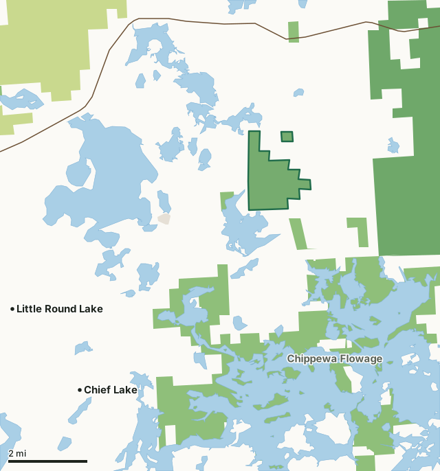
State wildlife areas, forests and other DNR landCounty forestNational forestLand trusts and other open landChief River Wildlife AreaCounty lineLakeHighway
| Size | 1,188 acres in 2 pieces |
|---|---|
| County | Sawyer County |
| Deer Management Unit | DMU 111 |
| DNR lists for hunting | deer and ruffed grouse |
| Public access (DNR) | Open to Hiking, Fishing, Hunting and Trapping |
| DNR property page | Chief River Wildlife Area |
| Nearest towns | Chief Lake (6 mi), Little Round Lake (6 mi) and New Post (7 mi) |
What is Chief River Wildlife Area like?
Chief River Wildlife Area is located in central Sawyer County, north of the Chippewa Flowage and east of Hayward, Wisconsin. Surrounded primarily by private land, Chief River Wildlife Area provides public recreation and access to upland, swamp hardwoods, lowland conifer and Mud-Callahan lakes. The 1,183-acre Chief River Wildlife Area was acquired during the late 1940s and early 1950s, with the last purchase made in 1952. A limited network of roads was constructed in 1954, and two easements were granted to improve access at no cost to the state.
The property provides public upland hunting opportunities, and the boat landing and parking area provide access to the Chief River as well as Mud and Callahan lakes. Mud and Callahan lakes offer fishing opportunities for gamefish (musky, largemouth bass) and panfish (bluegill, black crappie). Fishing opportunities also exist in Chief River, though shallow water means that fishing from a paddlecraft may be the only viable option. Originally, the property was intended to be managed as a deer yard, and much early work on browse management techniques in Wisconsin was done there. Initial attempts to produce quality browse were considered successful but experiments that followed proved too costly to continue. Active timber management continues on the property today using modern silviculture practices with a focus on quality wildlife habitat for both game and non-game species.
In the DNR's words, from its page for the property.
What can you hunt on Chief River Wildlife Area?
The DNR's page for Chief River Wildlife Area names deer and ruffed grouse. Each follows Wisconsin's statewide season and, for deer, the tags and rules of the deer management unit.
What are the rules on Chief River Wildlife Area?
The DNR's property map lists Chief River Wildlife Area as "Open to Hiking, Fishing, Hunting and Trapping". Hunting follows Wisconsin's statewide seasons and the rules posted on the property.
Activities the DNR lists for Chief River Wildlife Area: Birding, Canoeing, Cross-country skiing (no designated trail), Fishing, Hiking (no designated trail), Hunting, Snowmobile trail, Swimming, Trapping, Wild edibles/gathering and Wildlife viewing.
How many deer are taken around Chief River Wildlife Area?
Chief River Wildlife Area lies in DMU 111. The DNR registered 1,366 deer in DMU 111 in 2025.
| DMU | Chief River Wildlife Area acres in it | Deer, 2025 |
|---|---|---|
| DMU 111 | 1,188 | 1,366 |
Harvest for the whole deer management unit, not the property alone: Wisconsin DNR Deer Metrics (registered harvest by deer management unit).
How do you get to Chief River Wildlife Area?
Nearest towns: Chief Lake (6 miles), Little Round Lake (6 miles), New Post (7 miles) and Hayward (12 miles). Highways within 5 miles: WI 77.
What other public land is near Chief River Wildlife Area?
DNR properties within 10 miles:
- Chippewa Flowage: 14,069 acres, next to it
- Mud Callahan State Habitat Area: 94 acres, next to it
- Dead Creek Springs Fishery Area: 84 acres, 2.2 miles away
Public land within 3 miles of Chief River Wildlife Area
Counting Chief River Wildlife Area itself, 6,632 of the 31,973 acres within 3 miles of its boundary are public land open to the public (20.7%), by USGS PAD-US 4.1 (fee land open to the public).
| Manager | Acres within 3 miles |
|---|---|
| State wildlife areas, forests and other DNR land | 3,982 |
| National forest | 2,601 |
| Land trusts and other open land | 49 |
Questions hunters ask
Where is Chief River Wildlife Area?
In Sawyer County, 6 miles from Chief Lake. The DNR's property page has its maps and parking.
Is Chief River Wildlife Area open to hunting?
Yes. The DNR's property map lists it as "Open to Hiking, Fishing, Hunting and Trapping". Posted refuges or closed areas, where there are any, are marked on site.
Which deer management unit is Chief River Wildlife Area in?
DMU 111.
How much public land is around Chief River Wildlife Area?
6,632 acres within 3 miles of its boundary, Chief River Wildlife Area included, by PAD-US 4.1. The closest other DNR property is Chippewa Flowage (next to it).
Get a Wisconsin hunt plan when they open
Hunt plans for Wisconsin are coming. Join the list and you'll hear first. The first 50 hunters in each new state get their plan free.
Until then, the free FilledTag app for iPhone has a map that works in every state, Wisconsin included.
Where these facts come from
- Area description, species, rules and directions: DNR, Chief River Wildlife Area; Wisconsin DNR managed lands open to hunting.
- Boundary and acres: the DNR's map layer above. Surrounding public land: USGS PAD-US 4.1 (fee land open to the public).
- Deer harvest: Wisconsin DNR Deer Metrics (registered harvest by deer management unit).
FilledTag is not part of the Wisconsin Department of Natural Resources. Check the DNR's rules and posted signs before you go.