Chiwaukee Prairie-Carol Beach State Natural Area: hunting and access
Chiwaukee Prairie-Carol Beach State Natural Area is 567 acres of land managed by the Wisconsin DNR in Kenosha County, 3 miles from Pleasant Prairie. Hunters registered 510 deer in Kenosha County in 2025.
Data updated October 2026. Area facts: the DNR's DNR property data, read 2026-10. Harvest: DNR Deer Metrics.
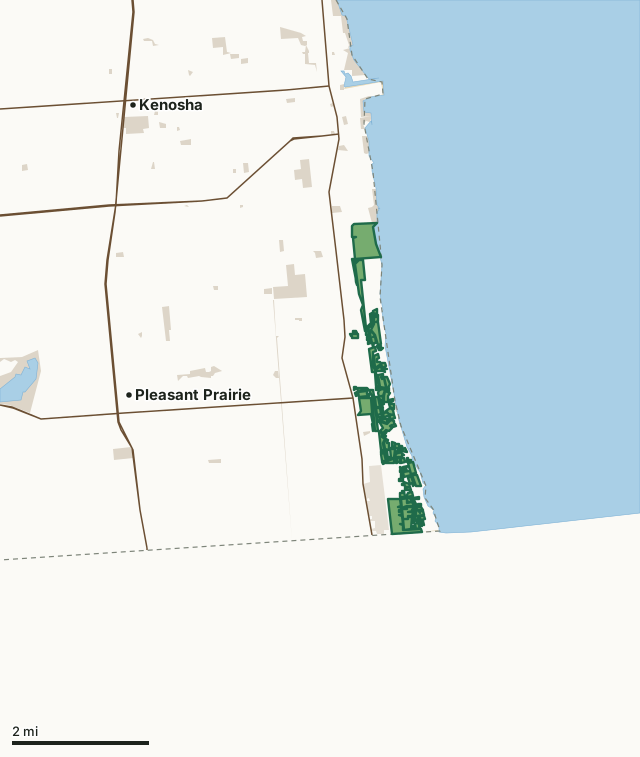
State wildlife areas, forests and other DNR landState parksOther county, city and regional landLand trusts and other open landChiwaukee Prairie-Carol Beach State Natural AreaCounty lineLakeHighway
| Size | 567 acres in 92 pieces |
|---|---|
| County | Kenosha County |
| Deer Management Unit | Kenosha County |
| Public access (DNR) | Open to Hiking, Fishing, Hunting and Trapping |
| DNR property page | Chiwaukee Prairie |
| Nearest towns | Pleasant Prairie (3 mi), Kenosha (4 mi) and Somers (7 mi) |
What is Chiwaukee Prairie-Carol Beach State Natural Area like?
Chiwaukee Prairie is situated on a gently undulating ridge and swale topography created when the level of glacial Lake Michigan was lowered in stages. It is one of the largest prairie complexes in the state and the most intact coastal wetland in southeastern Wisconsin. The prairie contains an exceptional diversity of plants and animals -- more than 400 species of vascular plants have been found here. The natural area features a mosaic of plant communities, ranging from southern sedge meadow, wet prairie and wet-mesic prairie in the low areas, to dry-mesic prairie on the slightly elevated sandy ridges. Portions of the site are classified as calcareous fen, inhabited by calcium-loving plants. Oak opening dominated by bur and black oaks occupies higher, drier ground along the southern and western parts of the preserve.
The map areas in green (see Maps tab) are larger parcels and offer the best hunting opportunities. The general public uses these areas and other nearby public lands for many recreational activities. Make sure you know where these other recreational opportunities are located for safety and to avoid user conflicts. The map areas in black (see Maps tab) are small parcels (usually less than 2 acres) that have limited hunting opportunities based on parcel size and state laws restricting the discharge of firearms such as distance from roads and residences. Hunters should always follow the 4 Rules of Firearm Safety (TABK):. The natural area consists of two parts, separated by 116th Street. The southern portion is a large, contiguous prairie area; the northern part consists of prairie fragmented by roads and scattered homes.
In the DNR's words, from its page for the property.
What are the rules on Chiwaukee Prairie-Carol Beach State Natural Area?
The DNR's property map lists Chiwaukee Prairie-Carol Beach State Natural Area as "Open to Hiking, Fishing, Hunting and Trapping". Hunting follows Wisconsin's statewide seasons and the rules posted on the property.
How many deer are taken around Chiwaukee Prairie-Carol Beach State Natural Area?
Chiwaukee Prairie-Carol Beach State Natural Area lies in Kenosha County. The DNR registered 510 deer in Kenosha County in 2025, against 419 in 2024.
| DMU | Chiwaukee Prairie-Carol Beach State Natural Area acres in it | Deer, 2025 | Deer, 2024 | Deer, 2023 |
|---|---|---|---|---|
| Kenosha County | 567 | 510 | 419 | 481 |
Harvest for the whole deer management unit, not the property alone: Wisconsin DNR Deer Metrics (registered harvest by deer management unit).
How do you get to Chiwaukee Prairie-Carol Beach State Natural Area?
Nearest towns: Pleasant Prairie (3 miles), Kenosha (4 miles), Somers (7 miles) and Elmwood Park (9 miles). Highways within 5 miles: WI 31, WI 32, WI 50, WI 165 and WI 158.
What other public land is near Chiwaukee Prairie-Carol Beach State Natural Area?
DNR properties within 10 miles:
- George Lake State Habitat Area: 161 acres, 10 miles away
Public land within 3 miles of Chiwaukee Prairie-Carol Beach State Natural Area
Counting Chiwaukee Prairie-Carol Beach State Natural Area itself, 1,242 of the 38,651 acres within 3 miles of its boundary are public land open to the public (3.2%), by USGS PAD-US 4.1 (fee land open to the public).
| Manager | Acres within 3 miles |
|---|---|
| State wildlife areas, forests and other DNR land | 574 |
| Other county, city and regional land | 502 |
| Land trusts and other open land | 154 |
| State parks | 12 |
Questions hunters ask
Where is Chiwaukee Prairie-Carol Beach State Natural Area?
In Kenosha County, 3 miles from Pleasant Prairie. The DNR's property page has its maps and parking.
Is Chiwaukee Prairie-Carol Beach State Natural Area open to hunting?
Yes. The DNR's property map lists it as "Open to Hiking, Fishing, Hunting and Trapping". Posted refuges or closed areas, where there are any, are marked on site.
Which deer management unit is Chiwaukee Prairie-Carol Beach State Natural Area in?
Kenosha County.
How much public land is around Chiwaukee Prairie-Carol Beach State Natural Area?
1,242 acres within 3 miles of its boundary, Chiwaukee Prairie-Carol Beach State Natural Area included, by PAD-US 4.1. The closest other DNR property is George Lake State Habitat Area (10 miles).
Get a Wisconsin hunt plan when they open
Hunt plans for Wisconsin are coming. Join the list and you'll hear first. The first 50 hunters in each new state get their plan free.
Until then, the free FilledTag app for iPhone has a map that works in every state, Wisconsin included.
Where these facts come from
- Area description, species, rules and directions: DNR, Chiwaukee Prairie-Carol Beach State Natural Area; Wisconsin DNR managed lands open to hunting.
- Boundary and acres: the DNR's map layer above. Surrounding public land: USGS PAD-US 4.1 (fee land open to the public).
- Deer harvest: Wisconsin DNR Deer Metrics (registered harvest by deer management unit).
FilledTag is not part of the Wisconsin Department of Natural Resources. Check the DNR's rules and posted signs before you go.