Clam River Fishery Area: hunting and access
Clam River Fishery Area is 2,575 acres of land managed by the Wisconsin DNR in Burnett County, 5 miles from Barronett. Hunters registered 2,861 deer in DMU Burnett in 2025.
Data updated October 2026. Area facts: the DNR's DNR property data, read 2026-10. Harvest: DNR Deer Metrics.
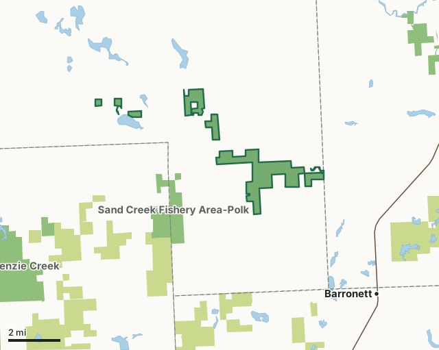
State wildlife areas, forests and other DNR landCounty forestClam River Fishery AreaCounty lineLakeHighway
| Size | 2,575 acres in 10 pieces |
|---|---|
| County | Burnett County |
| Deer Management Unit | DMU Burnett |
| Public access (DNR) | Open to Hiking, Fishing, Hunting and Trapping |
| DNR property page | Clam River Fishery Area |
| Nearest towns | Barronett (5 mi), Shell Lake (6 mi) and Siren (9 mi) |
What is Clam River Fishery Area like?
The Clam River Fishery Area is a 2,323 acre property in the southeast part of Burnett County, with portions of the property in Roosevelt, Dewey, and Lafollette Townships, presently consisting of seven separate parcels. The premiere wetland habitat on this property is the excellent Clam River trout stream and associated marshes. The uplands consist of aspen, northern hardwood, swamp hardwoods, oak, pine, and numerous old fields and forest openings. The Clam River is an excellent trout stream of northwestern Wisconsin. The North Fork of the Clam River originates as a small, intermittent stream in Washburn County. It rapidly enlarges in size as it is fed by a number of trout streams including Krantz Creek, the South Fork of the Clam River, Sand Creek, Spencer Creek, Indian Creek, and the two feeder streams from Clam River Springs and Bass Lake Springs.
A total of 5.0 miles of the North Branch and the entire 3.6 miles of the South Branch of the Clam River are class 1 trout water, while 14.0 miles of the stream from the County Hwy H bridge downstream to Spencer Lake is a class 2 trout stream. The Clam River Fishery Area encompasses all of class 1 and class 2 trout waters in Burnett County. Numerous points of historical interest exist within the Clam River Fishery Area and have been researched by the Burnett County Historical Society [exit DNR]. Probably most notable is the old Arbuckle House and Logging Dam. This house served as a stopping place for travelers along the old Stillwater to La Pointe Mail Road. The Sour Bean, Oxbow, and Forks were three other logging dams that are known to have existed along the North Fork of the Clam River during the earlier logging era.
In the DNR's words, from its page for the property.
What are the rules on Clam River Fishery Area?
The DNR's property map lists Clam River Fishery Area as "Open to Hiking, Fishing, Hunting and Trapping". Hunting follows Wisconsin's statewide seasons and the rules posted on the property.
Activities the DNR lists for Clam River Fishery Area: Hunting, Trapping, Hiking, Snowshoeing and Wildlife viewing.
How many deer are taken around Clam River Fishery Area?
Clam River Fishery Area lies in DMU Burnett. The DNR registered 2,861 deer in DMU Burnett in 2025.
| DMU | Clam River Fishery Area acres in it | Deer, 2025 |
|---|---|---|
| DMU Burnett | 2,575 | 2,861 |
Harvest for the whole deer management unit, not the property alone: Wisconsin DNR Deer Metrics (registered harvest by deer management unit).
How do you get to Clam River Fishery Area?
Nearest towns: Barronett (5 miles), Shell Lake (6 miles), Siren (9 miles) and Lewis (9 miles). Highways within 5 miles: WI 70 and US 63.
What other public land is near Clam River Fishery Area?
DNR properties within 10 miles:
- Sand Creek Fishery Area-Polk: 1,436 acres, 1.4 miles away
- Spring Creek Fishery Area: 72 acres, 4.3 miles away
- Clam Lake Wildlife Area: 459 acres, 4.5 miles away
- State Ice Age Trail Area (SIATA): 4,676 acres, 4.7 miles away
Public land within 3 miles of Clam River Fishery Area
Counting Clam River Fishery Area itself, 3,552 of the 67,025 acres within 3 miles of its boundary are public land open to the public (5.3%), by USGS PAD-US 4.1 (fee land open to the public).
| Manager | Acres within 3 miles |
|---|---|
| State wildlife areas, forests and other DNR land | 3,550 |
| Land trusts and other open land | 2 |
Questions hunters ask
Where is Clam River Fishery Area?
In Burnett County, 5 miles from Barronett. The DNR's property page has its maps and parking.
Is Clam River Fishery Area open to hunting?
Yes. The DNR's property map lists it as "Open to Hiking, Fishing, Hunting and Trapping". Posted refuges or closed areas, where there are any, are marked on site.
Which deer management unit is Clam River Fishery Area in?
DMU Burnett.
How much public land is around Clam River Fishery Area?
3,552 acres within 3 miles of its boundary, Clam River Fishery Area included, by PAD-US 4.1. The closest other DNR property is Sand Creek Fishery Area-Polk (1.4 miles).
Get a Wisconsin hunt plan when they open
Hunt plans for Wisconsin are coming. Join the list and you'll hear first. The first 50 hunters in each new state get their plan free.
Until then, the free FilledTag app for iPhone has a map that works in every state, Wisconsin included.
Where these facts come from
- Area description, species, rules and directions: DNR, Clam River Fishery Area; Wisconsin DNR managed lands open to hunting.
- Boundary and acres: the DNR's map layer above. Surrounding public land: USGS PAD-US 4.1 (fee land open to the public).
- Deer harvest: Wisconsin DNR Deer Metrics (registered harvest by deer management unit).
FilledTag is not part of the Wisconsin Department of Natural Resources. Check the DNR's rules and posted signs before you go.