Coffey Swamp State Natural Area: hunting and access
Coffey Swamp State Natural Area is 191 acres of land managed by the Wisconsin DNR in Door County, 13 miles from Ellison Bay. Hunters registered 4,302 deer in Door County in 2025.
Data updated October 2026. Area facts: the DNR's DNR property data, read 2026-10. Harvest: DNR Deer Metrics.
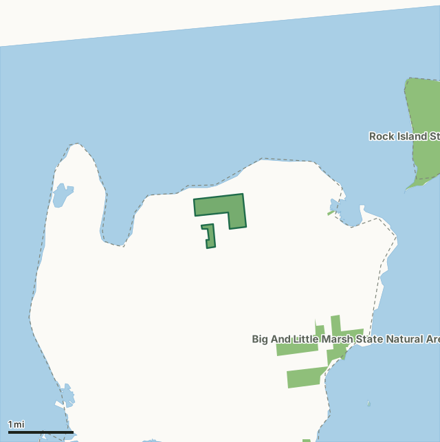
State wildlife areas, forests and other DNR landNational wildlife refuges and waterfowl production areasCoffey Swamp State Natural AreaCounty lineLakeHighway
| Size | 191 acres in 2 pieces |
|---|---|
| County | Door County |
| Deer Management Unit | Door County |
| Public access (DNR) | Open to Hiking, Fishing, Hunting and Trapping |
| DNR property page | Coffey Swamp |
| Nearest towns | Ellison Bay (13 mi), Sister Bay (18 mi) and Ephraim (21 mi) |
What is Coffey Swamp State Natural Area like?
Coffey Swamp occupies a former embayment of Lake Michigan along the northern coast of Washington Island. The natural area features a shallow, hard water seepage pond with a substrate of pure marl that nearly dries up in late summer and during years when the water level of Lake Michigan is low. Surrounding the pond is an open, treeless, boreal-rich fen dominated by wire-leaved sedges, sweet gale, and hoary willow. Boreal-rich fens are similar to their southern Wisconsin counterparts in having alkaline, saturated, peaty soils. They differ compositionally by having species more typical of nutrient-poor northern wetlands such as round-leaved sundew, pitcher plant, cotton-grass, bog-rosemary, Labrador-tea, and bogbean. The fen also supports many rare plants. Adjoining the fen is a northern wet-mesic forest dominated by white cedar situated on peat over gravel and sand ridges.
From Detroit Harbor, go north and east on County W 5.8 miles. Park along the road and walk north into the natural area. Read the Coffey Swamp management plan [PDF] for details.
In the DNR's words, from its page for the property.
What are the rules on Coffey Swamp State Natural Area?
The DNR's property map lists Coffey Swamp State Natural Area as "Open to Hiking, Fishing, Hunting and Trapping". Hunting follows Wisconsin's statewide seasons and the rules posted on the property.
How many deer are taken around Coffey Swamp State Natural Area?
Coffey Swamp State Natural Area lies in Door County. The DNR registered 4,302 deer in Door County in 2025, against 4,225 in 2024.
| DMU | Coffey Swamp State Natural Area acres in it | Deer, 2025 | Deer, 2024 | Deer, 2023 |
|---|---|---|---|---|
| Door County | 191 | 4,302 | 4,225 | 3,793 |
Harvest for the whole deer management unit, not the property alone: Wisconsin DNR Deer Metrics (registered harvest by deer management unit).
How do you get to Coffey Swamp State Natural Area?
Nearest towns: Ellison Bay (13 miles), Sister Bay (18 miles), Ephraim (21 miles) and Baileys Harbor (25 miles).
What other public land is near Coffey Swamp State Natural Area?
DNR properties within 10 miles:
- Rock Island State Park: 985 acres, 1.3 miles away
- Big And Little Marsh State Natural Area: 328 acres, 1.7 miles away
- Grand Traverse Island State Park: 26 acres, 4.5 miles away
- Newport State Park: 2,467 acres, 9.1 miles away
Public land within 3 miles of Coffey Swamp State Natural Area
Counting Coffey Swamp State Natural Area itself, 774 of the 23,643 acres within 3 miles of its boundary are public land open to the public (3.3%), by USGS PAD-US 4.1 (fee land open to the public).
| Manager | Acres within 3 miles |
|---|---|
| State wildlife areas, forests and other DNR land | 773 |
| State parks | 1 |
Questions hunters ask
Where is Coffey Swamp State Natural Area?
In Door County, 13 miles from Ellison Bay. The DNR's property page has its maps and parking.
Is Coffey Swamp State Natural Area open to hunting?
Yes. The DNR's property map lists it as "Open to Hiking, Fishing, Hunting and Trapping". Posted refuges or closed areas, where there are any, are marked on site.
Which deer management unit is Coffey Swamp State Natural Area in?
Door County.
How much public land is around Coffey Swamp State Natural Area?
774 acres within 3 miles of its boundary, Coffey Swamp State Natural Area included, by PAD-US 4.1. The closest other DNR property is Rock Island State Park (1.3 miles).
Get a Wisconsin hunt plan when they open
Hunt plans for Wisconsin are coming. Join the list and you'll hear first. The first 50 hunters in each new state get their plan free.
Until then, the free FilledTag app for iPhone has a map that works in every state, Wisconsin included.
Where these facts come from
- Area description, species, rules and directions: DNR, Coffey Swamp State Natural Area; Wisconsin DNR managed lands open to hunting.
- Boundary and acres: the DNR's map layer above. Surrounding public land: USGS PAD-US 4.1 (fee land open to the public).
- Deer harvest: Wisconsin DNR Deer Metrics (registered harvest by deer management unit).
FilledTag is not part of the Wisconsin Department of Natural Resources. Check the DNR's rules and posted signs before you go.