Crex Meadows Wildlife Area: hunting and access
Crex Meadows Wildlife Area is 29,812 acres of land managed by the Wisconsin DNR in Burnett County, next to Grantsburg. The DNR's page for it names deer, wild turkey, ducks and geese, bear and small game among the game here. Hunters registered 3,490 deer in DMU 108 in 2025.
Data updated October 2026. Area facts: the DNR's DNR property data, read 2026-10. Harvest: DNR Deer Metrics.
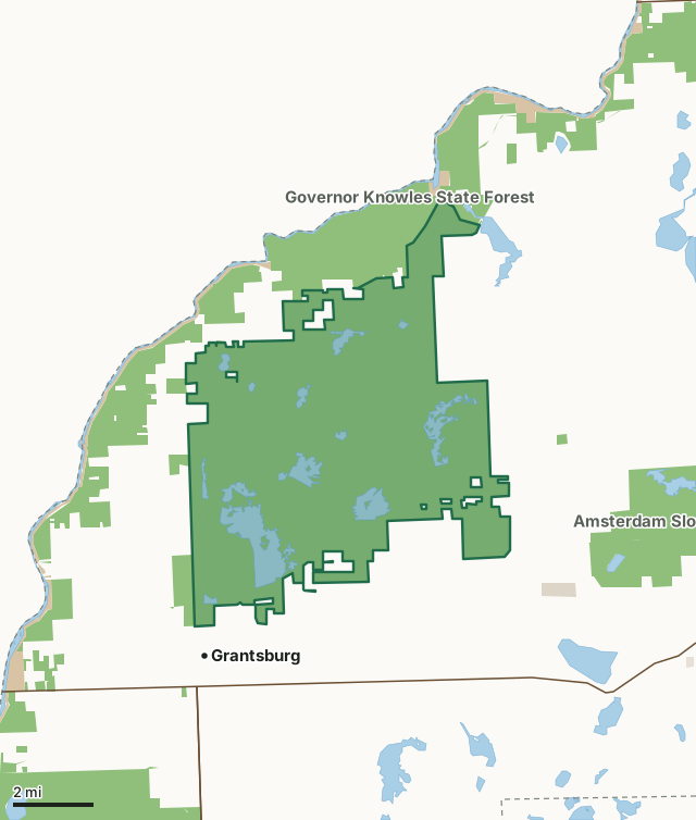
State wildlife areas, forests and other DNR landNational park landOther county, city and regional landLand trusts and other open landCrex Meadows Wildlife AreaCounty lineLakeHighway
| Size | 29,812 acres in 2 pieces |
|---|---|
| County | Burnett County |
| Deer Management Unit | DMU 108 |
| DNR lists for hunting | deer, wild turkey, ducks and geese, bear and small game |
| Public access (DNR) | Open to Hiking, Fishing, Hunting and Trapping |
| DNR property page | Crex Meadows Wildlife Area |
| Nearest towns | Grantsburg (next to it), Siren (7 mi) and Webster (8 mi) |
What is Crex Meadows Wildlife Area like?
Crex Meadows Wildlife Area is a 30,000-acre property of wetlands, pine/oak barrens and forests scattered across a gently rolling landscape. It is located in western Burnett County. Find it from Hwy 70 in Grantsburg. Directional signs will guide you through Grantsburg to the Crex Meadows Wildlife Education and Visitor Center, located at the intersection of County Road F and County Road D. The center contains a sales area, information center, library, auditorium, exhibits and classrooms. Crex Meadows is open year-round, with something to do and see during every season. It receives more than 100,000 visitors each year, most of whom come to view wildlife. The popularity of Crex is attributed to its large size, spectacular vistas and great diversity of plants and wildlife. Well-maintained roads, observation areas and a rest area provide excellent access and wildlife viewing opportunities.
Some visitors come to hunt or trap. Except for the 2,400-acre refuge, the entire area is open to hunting and trapping. Crex provides abundant hunting opportunities for deer, bears, turkeys, waterfowl and various small game. Trappers have opportunities for nearly every furbearer found in Wisconsin. Crex Meadows is part of the Northwest Sands Ecological Landscape. This landscape extends from northern Polk County to southern Bayfield County and covers nearly 2,000 square miles. This large, sandy plain was left when the glacier retreated approximately 12,000 years ago. The southern portion of the landscape, where Crex is located, contains huge marshes. These marshes are leftovers from when the glacier carved out an ancient lake called Glacial Lake Grantsburg.
In the DNR's words, from its page for the property.
What can you hunt on Crex Meadows Wildlife Area?
The DNR's page for Crex Meadows Wildlife Area names deer, wild turkey, ducks and geese, bear and small game. Each follows Wisconsin's statewide season and, for deer, the tags and rules of the deer management unit.
What are the rules on Crex Meadows Wildlife Area?
The DNR's property map lists Crex Meadows Wildlife Area as "Open to Hiking, Fishing, Hunting and Trapping". Hunting follows Wisconsin's statewide seasons and the rules posted on the property.
Activities the DNR lists for Crex Meadows Wildlife Area: Auto travel, Boating, Birding, Camping (Seasonal, September 1 - December 31, at the Rest Area only), Canoeing, Cross-country skiing (no designated trail), Hiking (on and off a designated trail), Hunting ( esp. waterfowl, deer, bear, turkey and small game), Kayaking, Trapping, Snowmobiling trail, Wild edibles/gathering (esp. blueberries), Wild rice harvesting and Wildlife viewing.
How many deer are taken around Crex Meadows Wildlife Area?
Crex Meadows Wildlife Area lies in DMU 108. The DNR registered 3,490 deer in DMU 108 in 2025.
| DMU | Crex Meadows Wildlife Area acres in it | Deer, 2025 |
|---|---|---|
| DMU 108 | 29,812 | 3,490 |
Harvest for the whole deer management unit, not the property alone: Wisconsin DNR Deer Metrics (registered harvest by deer management unit).
How do you get to Crex Meadows Wildlife Area?
Nearest towns: Grantsburg (next to it), Siren (7 miles), Webster (8 miles) and Danbury (9 miles). Highways within 5 miles: WI 70, WI 87 and WI 48.
What other public land is near Crex Meadows Wildlife Area?
DNR properties within 10 miles:
- Governor Knowles State Forest: 21,307 acres, next to it
- Grantsburg Station: 20 acres, 1.5 miles away
- Amsterdam Sloughs Wildlife Area: 5,099 acres, 1.9 miles away
- Fish Lake Wildlife Area: 13,535 acres, 3.6 miles away
Public land within 3 miles of Crex Meadows Wildlife Area
Counting Crex Meadows Wildlife Area itself, 42,343 of the 115,935 acres within 3 miles of its boundary are public land open to the public (36.5%), by USGS PAD-US 4.1 (fee land open to the public).
| Manager | Acres within 3 miles |
|---|---|
| State wildlife areas, forests and other DNR land | 41,325 |
| National park land | 835 |
| Other county, city and regional land | 181 |
| Land trusts and other open land | 2 |
Questions hunters ask
Where is Crex Meadows Wildlife Area?
In Burnett County, next to Grantsburg. The DNR's property page has its maps and parking.
Is Crex Meadows Wildlife Area open to hunting?
Yes. The DNR's property map lists it as "Open to Hiking, Fishing, Hunting and Trapping". Posted refuges or closed areas, where there are any, are marked on site.
Which deer management unit is Crex Meadows Wildlife Area in?
DMU 108.
How much public land is around Crex Meadows Wildlife Area?
42,343 acres within 3 miles of its boundary, Crex Meadows Wildlife Area included, by PAD-US 4.1. The closest other DNR property is Governor Knowles State Forest (next to it).
Get a Wisconsin hunt plan when they open
Hunt plans for Wisconsin are coming. Join the list and you'll hear first. The first 50 hunters in each new state get their plan free.
Until then, the free FilledTag app for iPhone has a map that works in every state, Wisconsin included.
Where these facts come from
- Area description, species, rules and directions: DNR, Crex Meadows Wildlife Area; Wisconsin DNR managed lands open to hunting.
- Boundary and acres: the DNR's map layer above. Surrounding public land: USGS PAD-US 4.1 (fee land open to the public).
- Deer harvest: Wisconsin DNR Deer Metrics (registered harvest by deer management unit).
FilledTag is not part of the Wisconsin Department of Natural Resources. Check the DNR's rules and posted signs before you go.