Dunn Lake State Natural Area: hunting and access
Dunn Lake State Natural Area is 585 acres of land managed by the Wisconsin DNR in Vilas County, 6 miles from Boulder Junction. Hunters registered 802 deer in DMU 122 in 2025.
Data updated October 2026. Area facts: the DNR's DNR property data, read 2026-10. Harvest: DNR Deer Metrics.
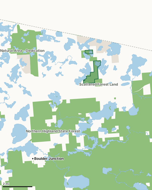
State wildlife areas, forests and other DNR landNational forestLand trusts and other open landDunn Lake State Natural AreaCounty lineLakeHighway
| Size | 585 acres in 2 pieces |
|---|---|
| County | Vilas County |
| Deer Management Unit | DMU 122 |
| Public access (DNR) | Open to Hiking, Fishing, Hunting and Trapping |
| DNR property page | Dunn Lake |
| Nearest towns | Boulder Junction (6 mi), Sayner (14 mi) and Woodruff (21 mi) |
What is Dunn Lake State Natural Area like?
Dunn Lake features a mosaic of communities surrounding the lake, giving the area a wilderness aspect. The site contains an outstanding example of the northern mesic forest, with super-canopy white pine above large hemlock, yellow birch, sugar maple, and basswood. This undisturbed stand lies on the northeast side of Dunn Lake and extends eastward across the Presque Isle River. Another old-growth stand lies on an upland peninsula west of Sanborn Lake. The Presque Isle River is a meandering, soft, warm water stream that supports a high diversity of native aquatic plants. Bordering the stream are excellent examples of northern sedge meadows, alder thickets, and northern wet forest communities. Recent beaver activity has altered the composition of these. The uplands to the south have been subjected to intensive timber harvest. Bald eagles have nested in the large white pines.
Public access is via the Presque Isle River. There is no upland public access at this time. Please contact the State Natural Areas Program for more information.
In the DNR's words, from its page for the property.
What are the rules on Dunn Lake State Natural Area?
The DNR's property map lists Dunn Lake State Natural Area as "Open to Hiking, Fishing, Hunting and Trapping". Hunting follows Wisconsin's statewide seasons and the rules posted on the property.
How many deer are taken around Dunn Lake State Natural Area?
Dunn Lake State Natural Area lies in DMU 122. The DNR registered 802 deer in DMU 122 in 2025.
| DMU | Dunn Lake State Natural Area acres in it | Deer, 2025 |
|---|---|---|
| DMU 122 | 585 | 802 |
Harvest for the whole deer management unit, not the property alone: Wisconsin DNR Deer Metrics (registered harvest by deer management unit).
How do you get to Dunn Lake State Natural Area?
Nearest towns: Boulder Junction (6 miles), Sayner (14 miles), Woodruff (21 miles) and Lac du Flambeau (22 miles).
What other public land is near Dunn Lake State Natural Area?
DNR properties within 10 miles:
- Northern Highland State Forest: 176,323 acres, 1 mile away
Public land within 3 miles of Dunn Lake State Natural Area
Counting Dunn Lake State Natural Area itself, 5,839 of the 30,967 acres within 3 miles of its boundary are public land open to the public (18.9%), by USGS PAD-US 4.1 (fee land open to the public).
| Manager | Acres within 3 miles |
|---|---|
| State wildlife areas, forests and other DNR land | 4,869 |
| Land trusts and other open land | 958 |
| National forest | 12 |
Questions hunters ask
Where is Dunn Lake State Natural Area?
In Vilas County, 6 miles from Boulder Junction. The DNR's property page has its maps and parking.
Is Dunn Lake State Natural Area open to hunting?
Yes. The DNR's property map lists it as "Open to Hiking, Fishing, Hunting and Trapping". Posted refuges or closed areas, where there are any, are marked on site.
Which deer management unit is Dunn Lake State Natural Area in?
DMU 122.
How much public land is around Dunn Lake State Natural Area?
5,839 acres within 3 miles of its boundary, Dunn Lake State Natural Area included, by PAD-US 4.1. The closest other DNR property is Northern Highland State Forest (1 mile).
Get a Wisconsin hunt plan when they open
Hunt plans for Wisconsin are coming. Join the list and you'll hear first. The first 50 hunters in each new state get their plan free.
Until then, the free FilledTag app for iPhone has a map that works in every state, Wisconsin included.
Where these facts come from
- Area description, species, rules and directions: DNR, Dunn Lake State Natural Area; Wisconsin DNR managed lands open to hunting.
- Boundary and acres: the DNR's map layer above. Surrounding public land: USGS PAD-US 4.1 (fee land open to the public).
- Deer harvest: Wisconsin DNR Deer Metrics (registered harvest by deer management unit).
FilledTag is not part of the Wisconsin Department of Natural Resources. Check the DNR's rules and posted signs before you go.