Engle Creek Springs Fishery Area: hunting and access
Engle Creek Springs Fishery Area is 190 acres of land managed by the Wisconsin DNR in Barron County, 6 miles from Rice Lake. The DNR's page for it names deer, pheasants, ducks and geese, ruffed grouse, woodcock, rabbits and squirrels and small game among the game here. Hunters registered 6,376 deer in Barron County in 2025.
Data updated October 2026. Area facts: the DNR's DNR property data, read 2026-10. Harvest: DNR Deer Metrics.
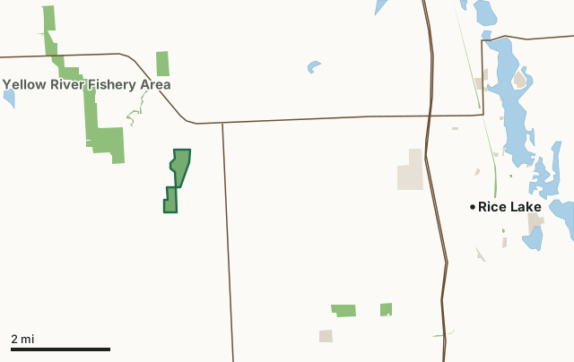
State wildlife areas, forests and other DNR landOther county, city and regional landLand trusts and other open landEngle Creek Springs Fishery AreaCounty lineLakeHighway
| Size | 190 acres in 2 pieces |
|---|---|
| County | Barron County |
| Deer Management Unit | Barron County |
| DNR lists for hunting | deer, pheasants, ducks and geese, ruffed grouse, woodcock, rabbits and squirrels and small game |
| Public access (DNR) | Open to Hiking, Fishing, Hunting and Trapping |
| DNR property page | Engle Creek Springs Fishery Area |
| Nearest towns | Rice Lake (6 mi), Barron (6 mi) and Cumberland (8 mi) |
What is Engle Creek Springs Fishery Area like?
The Engle Creek Springs Fishery Area is located in central Barron County, primarily an agricultural area. The area surrounding Engle Creek was originally recognized as a valuable resource worthy of acquisition mainly because of six spring ponds associated with the stream, and Engle Creek itself is recognized as a high quality trout stream. The surrounding lands are considered to be an excellent strip of permanent wildlife habitat located in an intensively farmed region. The Fishery Area receives considerable use by hunters and trappers for an area of its size. Hunting pressure is directed mainly towards white-tailed deer and ruffed grouse. The Fishery Area has considerable aesthetic value and is a strip of wildland in a mostly agricultural area. As a result, there are other recreational and educational activities such as nature hiking and berry picking.
The species composition of waters in the Fishery Area is characteristic of a coldwater fishery, and both the spring ponds and stream are managed for brook trout. A few brown trout, the mottled sculpin, and brook sticklebacks represent the remaining coldwater species. Natural reproduction is adequate enough to that native brook trout are abundant in the stream. In contrast, no known natural reproduction of trout exists in the spring ponds, and until a fish barrier was constructed recently, periodic movements of northern pike into the ponds from the Yellow River destroyed many trout. Eight other fish inhabit the fishery area including such panfishes as the black crappie, brown and black bullhead. Minnow species found include the white sucker, creek chub, mud minnow, and Johnny darter. The brook lamprey is also present.
In the DNR's words, from its page for the property.
What can you hunt on Engle Creek Springs Fishery Area?
The DNR's page for Engle Creek Springs Fishery Area names deer, pheasants, ducks and geese, ruffed grouse, woodcock, rabbits and squirrels and small game. Each follows Wisconsin's statewide season and, for deer, the tags and rules of the deer management unit.
What are the rules on Engle Creek Springs Fishery Area?
The DNR's property map lists Engle Creek Springs Fishery Area as "Open to Hiking, Fishing, Hunting and Trapping". Hunting follows Wisconsin's statewide seasons and the rules posted on the property.
Activities the DNR lists for Engle Creek Springs Fishery Area: Hunting - deer, fowl, & small game, Trapping, Hiking, Wildlife viewing, Fishing - trout and panfish, Bird watching and Berry picking.
How many deer are taken around Engle Creek Springs Fishery Area?
Engle Creek Springs Fishery Area lies in Barron County. The DNR registered 6,376 deer in Barron County in 2025, against 5,789 in 2024.
| DMU | Engle Creek Springs Fishery Area acres in it | Deer, 2025 | Deer, 2024 | Deer, 2023 |
|---|---|---|---|---|
| Barron County | 190 | 6,376 | 5,789 | 5,457 |
Harvest for the whole deer management unit, not the property alone: Wisconsin DNR Deer Metrics (registered harvest by deer management unit).
How do you get to Engle Creek Springs Fishery Area?
Nearest towns: Rice Lake (6 miles), Barron (6 miles), Cumberland (8 miles) and Haugen (8 miles). Highways within 5 miles: WI 48, WI 25 and US 53.
What other public land is near Engle Creek Springs Fishery Area?
DNR properties within 10 miles:
- Yellow River Fishery Area: 698 acres, 0.9 miles away
- Wild Rivers State Trail: 1,158 acres, 5.8 miles away
Public land within 3 miles of Engle Creek Springs Fishery Area
Counting Engle Creek Springs Fishery Area itself, 832 of the 24,395 acres within 3 miles of its boundary are public land open to the public (3.4%), by USGS PAD-US 4.1 (fee land open to the public).
| Manager | Acres within 3 miles |
|---|---|
| State wildlife areas, forests and other DNR land | 831 |
| Land trusts and other open land | 1 |
Questions hunters ask
Where is Engle Creek Springs Fishery Area?
In Barron County, 6 miles from Rice Lake. The DNR's property page has its maps and parking.
Is Engle Creek Springs Fishery Area open to hunting?
Yes. The DNR's property map lists it as "Open to Hiking, Fishing, Hunting and Trapping". Posted refuges or closed areas, where there are any, are marked on site.
Which deer management unit is Engle Creek Springs Fishery Area in?
Barron County.
How much public land is around Engle Creek Springs Fishery Area?
832 acres within 3 miles of its boundary, Engle Creek Springs Fishery Area included, by PAD-US 4.1. The closest other DNR property is Yellow River Fishery Area (0.9 miles).
Get a Wisconsin hunt plan when they open
Hunt plans for Wisconsin are coming. Join the list and you'll hear first. The first 50 hunters in each new state get their plan free.
Until then, the free FilledTag app for iPhone has a map that works in every state, Wisconsin included.
Where these facts come from
- Area description, species, rules and directions: DNR, Engle Creek Springs Fishery Area; Wisconsin DNR managed lands open to hunting.
- Boundary and acres: the DNR's map layer above. Surrounding public land: USGS PAD-US 4.1 (fee land open to the public).
- Deer harvest: Wisconsin DNR Deer Metrics (registered harvest by deer management unit).
FilledTag is not part of the Wisconsin Department of Natural Resources. Check the DNR's rules and posted signs before you go.