Grindstone Creek Fishery Area: hunting and access
Grindstone Creek Fishery Area is 410 acres of land managed by the Wisconsin DNR in Sawyer County, next to Little Round Lake.
Data updated October 2026. Area facts: the DNR's DNR property data, read 2026-10. Harvest: DNR Deer Metrics.
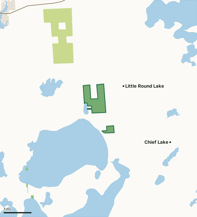
State wildlife areas, forests and other DNR landCounty forestLand trusts and other open landGrindstone Creek Fishery AreaCounty lineLakeHighway
| Size | 410 acres in 2 pieces |
|---|---|
| County | Sawyer County |
| Deer Management Unit | Lac Courte Oreilles Reservation |
| Public access (DNR) | Open to Hiking, Fishing, Hunting and Trapping |
| DNR property page | Grindstone Creek Fishery Area |
| Nearest towns | Little Round Lake (next to it), Chief Lake (2 mi) and Hayward (5 mi) |
What is Grindstone Creek Fishery Area like?
Grindstone Creek Fishery Area is a 262.2-acre parcel encompassing a small natural drainage lake, a trout stream (Swift Creek), 1.1 miles of Grindstone Creek, a class 1 trout stream, and three natural spring ponds. Upland resources of timber are predominantly aspen, with a mixture of red pine, black spruce, and tag alder. Also included as part of the Fishery Area is a small (3.2-acre) portion of Christner Lake. Warmwater species fishing in Christner Lake is one of the best pure, bass-bluegill fisheries in Sawyer County.
The Grindstone Creek Fishery Area is within the ceded territory and the Lac Courte Oreilles Indian (LCO) Reservation. All access to the Fishery Area is across Tribal land. Non-Tribal recreation users can fish on all the waters, access all the waters via navigable water, and hunt, trap, and harvest on public lands, but not on adjacent Tribal land. Members of the LCO Tribe have special hunting and fishing rights on public lands and waters within the ceded territory. Grindstone Creek Fishery Area is located in west-central Sawyer County, approximately 6 miles southeast of the City of Hayward. Go 4 miles east of Hayward on County Hwy B, then 3 miles south on County Hwy K to Grindstone Springs Rd, then west on Grindstone Springs Road ½ mile. T 40N, R 8W, section 8. Coldwater species angling opportunities on the spring ponds and warmwater opportunities in Christner Lake.
In the DNR's words, from its page for the property.
What are the rules on Grindstone Creek Fishery Area?
The DNR's property map lists Grindstone Creek Fishery Area as "Open to Hiking, Fishing, Hunting and Trapping". Hunting follows Wisconsin's statewide seasons and the rules posted on the property.
Activities the DNR lists for Grindstone Creek Fishery Area: Hunting, Trapping, Hiking, Wildlife viewing, Fishing - trout, northern pike, yellow perch, bass, bluegill, Bird watching, Pets and Berry picking.
How many deer are taken around Grindstone Creek Fishery Area?
Grindstone Creek Fishery Area lies in Lac Courte Oreilles Reservation.
| DMU | Grindstone Creek Fishery Area acres in it |
|---|---|
| Lac Courte Oreilles Reservation | 410 |
Harvest for the whole deer management unit, not the property alone: Wisconsin DNR Deer Metrics (registered harvest by deer management unit).
How do you get to Grindstone Creek Fishery Area?
Nearest towns: Little Round Lake (next to it), Chief Lake (2 miles), Hayward (5 miles) and Reserve (8 miles). Highways within 5 miles: WI 77, WI 27 and US 63.
What other public land is near Grindstone Creek Fishery Area?
Public land within 3 miles of Grindstone Creek Fishery Area
Counting Grindstone Creek Fishery Area itself, 1,327 of the 28,119 acres within 3 miles of its boundary are public land open to the public (4.7%), by USGS PAD-US 4.1 (fee land open to the public).
| Manager | Acres within 3 miles |
|---|---|
| County forest | 915 |
| State wildlife areas, forests and other DNR land | 412 |
Questions hunters ask
Where is Grindstone Creek Fishery Area?
In Sawyer County, next to Little Round Lake. The DNR's property page has its maps and parking.
Is Grindstone Creek Fishery Area open to hunting?
Yes. The DNR's property map lists it as "Open to Hiking, Fishing, Hunting and Trapping". Posted refuges or closed areas, where there are any, are marked on site.
Which deer management unit is Grindstone Creek Fishery Area in?
Lac Courte Oreilles Reservation.
How much public land is around Grindstone Creek Fishery Area?
1,327 acres within 3 miles of its boundary, Grindstone Creek Fishery Area included, by PAD-US 4.1.
Get a Wisconsin hunt plan when they open
Hunt plans for Wisconsin are coming. Join the list and you'll hear first. The first 50 hunters in each new state get their plan free.
Until then, the free FilledTag app for iPhone has a map that works in every state, Wisconsin included.
Where these facts come from
- Area description, species, rules and directions: DNR, Grindstone Creek Fishery Area; Wisconsin DNR managed lands open to hunting.
- Boundary and acres: the DNR's map layer above. Surrounding public land: USGS PAD-US 4.1 (fee land open to the public).
- Deer harvest: Wisconsin DNR Deer Metrics (registered harvest by deer management unit).
FilledTag is not part of the Wisconsin Department of Natural Resources. Check the DNR's rules and posted signs before you go.