Hardscrabble Prairie State Natural Area: hunting and access
Hardscrabble Prairie State Natural Area is 171 acres of land managed by the Wisconsin DNR in Lafayette and Grant counties, next to Hazel Green. Hunters registered 2,042 deer in Lafayette County in 2025.
Data updated October 2026. Area facts: the DNR's DNR property data, read 2026-10. Harvest: DNR Deer Metrics.
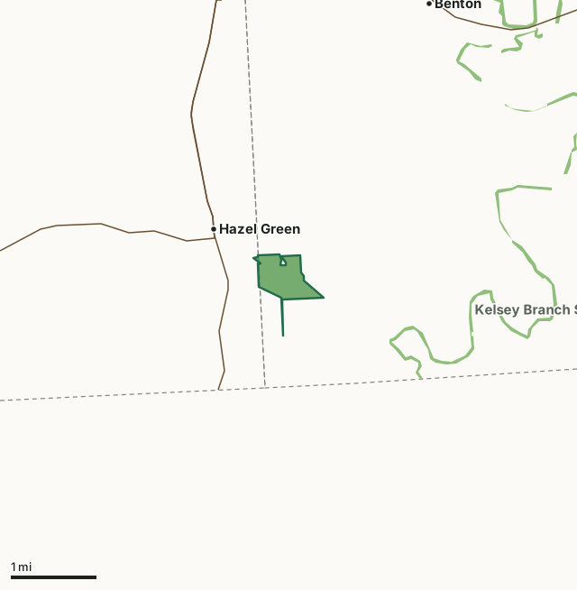
State wildlife areas, forests and other DNR landHardscrabble Prairie State Natural AreaCounty lineHighway
| Size | 171 acres |
|---|---|
| Counties | Lafayette County and Grant County |
| Deer Management Unit | Lafayette County |
| Public access (DNR) | Open to Hiking, Fishing, Hunting and Trapping |
| DNR property page | Hardscrabble Prairie |
| Nearest towns | Hazel Green (next to it), Benton (3 mi) and Cuba City (5 mi) |
What is Hardscrabble Prairie State Natural Area like?
Hardscrabble Prairie is a composite of oak opening and a very diverse dry prairie situated on a north-facing slope, an unusual exposure for the dry prairie community type. Abundant species include common ninebark, Culver’s-root, valerian, mountain mint, lead plant, showy goldenrod, purple prairie clover, prairie drop-seed, and side-oats grama grass. Other species are little blue-stem, June grass, pasque flower, alumroot, Illinois tick-trefoil, round-headed bush-clover, and shooting star. The lower area contains a dry creek bed with large open-grown bur oaks scattered throughout. Habitat heterogeneity and an abundance of nectaring plants make the prairie attractive to at least 16 other species of butterfly including silver-spotted skipper, common wood nymph, painted lady, great spangled fritillary, and meadow fritillary.
From the intersection of State Highway 80 and County Highway W in Hazel Green, go east on Highway W for 0.7 miles, then go south on Crawford Lane and park at the sewage treatment plant turnabout. Hardscrabble Prairie is owned by: Wisconsin DNR.
In the DNR's words, from its page for the property.
What are the rules on Hardscrabble Prairie State Natural Area?
The DNR's property map lists Hardscrabble Prairie State Natural Area as "Open to Hiking, Fishing, Hunting and Trapping". Hunting follows Wisconsin's statewide seasons and the rules posted on the property.
How many deer are taken around Hardscrabble Prairie State Natural Area?
Hardscrabble Prairie State Natural Area lies in Lafayette County. The DNR registered 2,042 deer in Lafayette County in 2025, against 2,083 in 2024.
| DMU | Hardscrabble Prairie State Natural Area acres in it | Deer, 2025 | Deer, 2024 | Deer, 2023 |
|---|---|---|---|---|
| Lafayette County | 170 | 2,042 | 2,083 | 2,403 |
Harvest for the whole deer management unit, not the property alone: Wisconsin DNR Deer Metrics (registered harvest by deer management unit).
How do you get to Hardscrabble Prairie State Natural Area?
Nearest towns: Hazel Green (next to it), Benton (3 miles), Cuba City (5 miles) and Shullsburg (10 miles). Highways within 5 miles: WI 11 and WI 80.
What other public land is near Hardscrabble Prairie State Natural Area?
DNR properties within 10 miles:
- Kelsey Branch SBE Area: 165 acres, 0.9 miles away
- Fever River SBE Area: 197 acres, 2.9 miles away
- Shullsburg Branch SBE Area: 93 acres, 4 miles away
- Pats Creek SBE Area: 22 acres, 7.5 miles away
- Madden Branch SBE Area: 42 acres, 7.6 miles away
- Snowden Branch SBE Area: 172 acres, 9.3 miles away
Public land within 3 miles of Hardscrabble Prairie State Natural Area
Counting Hardscrabble Prairie State Natural Area itself, 324 of the 23,643 acres within 3 miles of its boundary are public land open to the public (1.4%), by USGS PAD-US 4.1 (fee land open to the public).
| Manager | Acres within 3 miles |
|---|---|
| State wildlife areas, forests and other DNR land | 324 |
Questions hunters ask
Where is Hardscrabble Prairie State Natural Area?
In Lafayette and Grant counties, next to Hazel Green. The DNR's property page has its maps and parking.
Is Hardscrabble Prairie State Natural Area open to hunting?
Yes. The DNR's property map lists it as "Open to Hiking, Fishing, Hunting and Trapping". Posted refuges or closed areas, where there are any, are marked on site.
Which deer management unit is Hardscrabble Prairie State Natural Area in?
Lafayette County.
How much public land is around Hardscrabble Prairie State Natural Area?
324 acres within 3 miles of its boundary, Hardscrabble Prairie State Natural Area included, by PAD-US 4.1. The closest other DNR property is Kelsey Branch SBE Area (0.9 miles).
Get a Wisconsin hunt plan when they open
Hunt plans for Wisconsin are coming. Join the list and you'll hear first. The first 50 hunters in each new state get their plan free.
Until then, the free FilledTag app for iPhone has a map that works in every state, Wisconsin included.
Where these facts come from
- Area description, species, rules and directions: DNR, Hardscrabble Prairie State Natural Area; Wisconsin DNR managed lands open to hunting.
- Boundary and acres: the DNR's map layer above. Surrounding public land: USGS PAD-US 4.1 (fee land open to the public).
- Deer harvest: Wisconsin DNR Deer Metrics (registered harvest by deer management unit).
FilledTag is not part of the Wisconsin Department of Natural Resources. Check the DNR's rules and posted signs before you go.
Wisconsin hunting Lafayette County Grant County Lafayette County