Hogback Prairie State Natural Area: hunting and access
Hogback Prairie State Natural Area is 1,069 acres of land managed by the Wisconsin DNR in Crawford County, next to Steuben. Hunters registered 5,420 deer in Crawford County in 2025.
Data updated October 2026. Area facts: the DNR's DNR property data, read 2026-10. Harvest: DNR Deer Metrics.
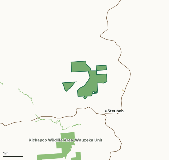
State wildlife areas, forests and other DNR landOther federal landHogback Prairie State Natural AreaCounty lineHighway
| Size | 1,069 acres in 4 pieces |
|---|---|
| County | Crawford County |
| Deer Management Unit | Crawford County |
| Public access (DNR) | Open to Hiking, Fishing, Hunting and Trapping |
| DNR property page | Hogback Prairie |
| Nearest towns | Steuben (next to it), Seneca (5 mi) and Bell Center (5 mi) |
What is Hogback Prairie State Natural Area like?
Hogback Prairie is situated on an impressive geological formation - a narrow, steep-sided limestone-capped ridge that rises 300' above the Citron Valley, a former oxbow of the nearby Kickapoo River. The hogback's western and eastern slopes support dry prairie vegetation from the ridge's crest down to its bases. There is also a small segment of north-facing prairie. The multiple aspects of the prairie have resulted in an unusual mix of plants, blending typical dry prairie species such as side oats grama, little blue-stem, purple prairie-clover and hoary vervain with species such as needle grass and mountain mint that are more characteristic of moister prairies. The aspect variability has also contributed to the existence of excellent populations of the many rare plants and animals found here.
A compass, topographic map, or GPS unit are useful tools for exploring larger, isolated SNAs. A GPS unit or compass and a detailed topographic map are valuable tools for exploring larger SNAs. Northern units are within the Kickapoo River Wildlife Area - Bell Center Unit, Crawford County. T8N-R4W, Sections 4, 5, 6. T9N-R4W, Sections 4, 5, 9, 10, 31, 32, 33. 1,192 acres. From the intersection of State Highway 179 and Bridge Street in Steuben, go north on Bridge Street for 0.2 miles, then west and north on Hughes Road for 2.1 miles, then west on Citron Valley Road for 0.25 miles. Park along the road and walk west into the natural area.
In the DNR's words, from its page for the property.
What are the rules on Hogback Prairie State Natural Area?
The DNR's property map lists Hogback Prairie State Natural Area as "Open to Hiking, Fishing, Hunting and Trapping". Hunting follows Wisconsin's statewide seasons and the rules posted on the property.
How many deer are taken around Hogback Prairie State Natural Area?
Hogback Prairie State Natural Area lies in Crawford County. The DNR registered 5,420 deer in Crawford County in 2025, against 5,067 in 2024.
| DMU | Hogback Prairie State Natural Area acres in it | Deer, 2025 | Deer, 2024 | Deer, 2023 |
|---|---|---|---|---|
| Crawford County | 1,069 | 5,420 | 5,067 | 5,067 |
Harvest for the whole deer management unit, not the property alone: Wisconsin DNR Deer Metrics (registered harvest by deer management unit).
How do you get to Hogback Prairie State Natural Area?
Nearest towns: Steuben (next to it), Seneca (5 miles), Bell Center (5 miles) and Mount Sterling (7 miles). Highways within 5 miles: WI 131, WI 179 and WI 27.
What other public land is near Hogback Prairie State Natural Area?
DNR properties within 10 miles:
- La Crosse Area Comprehensive Fishery Area: 2,495 acres, 1.3 miles away
- Kickapoo Wildlife Area-Wauzeka Unit: 5,584 acres, 1.7 miles away
- Kickapoo Wildlife Area-Bell Center Unit: 1,671 acres, 3.5 miles away
- Lower Wisconsin State Riverway: 47,767 acres, 6.3 miles away
- F G Wilson State Forest Nursery: 154 acres, 8.9 miles away
- Blackhawk-Kickapoo W S: 229 acres, 9.2 miles away
Public land within 3 miles of Hogback Prairie State Natural Area
Counting Hogback Prairie State Natural Area itself, 1,724 of the 32,743 acres within 3 miles of its boundary are public land open to the public (5.3%), by USGS PAD-US 4.1 (fee land open to the public).
| Manager | Acres within 3 miles |
|---|---|
| State wildlife areas, forests and other DNR land | 1,717 |
| Other federal land | 4 |
| Land trusts and other open land | 3 |
Questions hunters ask
Where is Hogback Prairie State Natural Area?
In Crawford County, next to Steuben. The DNR's property page has its maps and parking.
Is Hogback Prairie State Natural Area open to hunting?
Yes. The DNR's property map lists it as "Open to Hiking, Fishing, Hunting and Trapping". Posted refuges or closed areas, where there are any, are marked on site.
Which deer management unit is Hogback Prairie State Natural Area in?
Crawford County.
How much public land is around Hogback Prairie State Natural Area?
1,724 acres within 3 miles of its boundary, Hogback Prairie State Natural Area included, by PAD-US 4.1. The closest other DNR property is La Crosse Area Comprehensive Fishery Area (1.3 miles).
Get a Wisconsin hunt plan when they open
Hunt plans for Wisconsin are coming. Join the list and you'll hear first. The first 50 hunters in each new state get their plan free.
Until then, the free FilledTag app for iPhone has a map that works in every state, Wisconsin included.
Where these facts come from
- Area description, species, rules and directions: DNR, Hogback Prairie State Natural Area; Wisconsin DNR managed lands open to hunting.
- Boundary and acres: the DNR's map layer above. Surrounding public land: USGS PAD-US 4.1 (fee land open to the public).
- Deer harvest: Wisconsin DNR Deer Metrics (registered harvest by deer management unit).
FilledTag is not part of the Wisconsin Department of Natural Resources. Check the DNR's rules and posted signs before you go.