Holland Wildlife Area: hunting and access
Holland Wildlife Area is 536 acres of land managed by the Wisconsin DNR in Brown County, 2 miles from Greenleaf. The DNR's page for it names deer, wild turkey, pheasants and small game among the game here. Hunters registered 3,627 deer in Brown County in 2025.
Data updated October 2026. Area facts: the DNR's DNR property data, read 2026-10. Harvest: DNR Deer Metrics.
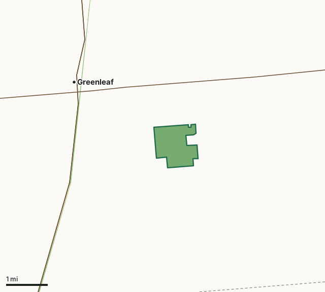
State wildlife areas, forests and other DNR landState parksHolland Wildlife AreaCounty lineHighway
| Size | 536 acres |
|---|---|
| County | Brown County |
| Deer Management Unit | Brown County |
| DNR lists for hunting | deer, wild turkey, pheasants and small game |
| Public access (DNR) | Open to Hiking, Fishing, Hunting and Trapping |
| DNR property page | Holland Wildlife Area |
| Nearest towns | Greenleaf (2 mi), Wrightstown (6 mi) and Forest Junction (7 mi) |
What is Holland Wildlife Area like?
Holland Wildlife Area is a 536-acre property consisting of bottomland hardwood forest, a small area of cedar forest and open grassland. In recent years managed grazing has been utilized to manage the grasslands. You may see cattle on-site during the growing season. The primary recreational uses at Holland are pheasant deer and small game hunting. Holland Wildlife Area receives pheasants annually through the Department’s stocking program. Bird watching, trail-less hiking and exploration are encouraged. Because of its close proximity to the urban areas of Green Bay and the Fox Cities, Holland Wildlife Area is heavily used.
Holland Wildlife Area has an embedded State Natural Area, Holland Red Maple Swamp. Emerald ash borer and changes in the local water table have impacted forest health on the property. Find Holland Wildlife Area from Brillion by way of Highway 10. Take Highway PP to the north. Go 7 miles north until Park Road, and then take a right. Go 0.75 miles to the property line. From Green Bay, take Highway 57 south to Highway 96 and go east on 96 to Highway PP. Turn right onto Hwy PP until Mill Road, then turn left after approximately 0.5 miles. Conservation grazing is the primary management method used on the property to maintain grasslands. Mowing, prescribed fire and occasional haying are also utilized to maintain open grassland. Invasive vascular and woody species are managed through grazing, cutting, mowing, fire and herbicide.
In the DNR's words, from its page for the property.
What can you hunt on Holland Wildlife Area?
The DNR's page for Holland Wildlife Area names deer, wild turkey, pheasants and small game. Each follows Wisconsin's statewide season and, for deer, the tags and rules of the deer management unit.
What are the rules on Holland Wildlife Area?
The DNR's property map lists Holland Wildlife Area as "Open to Hiking, Fishing, Hunting and Trapping". Hunting follows Wisconsin's statewide seasons and the rules posted on the property.
Activities the DNR lists for Holland Wildlife Area: Birding, Cross-country skiing (no designated trail), Hiking (no designated trail), Hunting (noted for pheasant [noon closure], deer, turkey and small game), Wild edibles/gathering and Wildlife viewing.
How many deer are taken around Holland Wildlife Area?
Holland Wildlife Area lies in Brown County. The DNR registered 3,627 deer in Brown County in 2025, against 3,302 in 2024.
| DMU | Holland Wildlife Area acres in it | Deer, 2025 | Deer, 2024 | Deer, 2023 |
|---|---|---|---|---|
| Brown County | 536 | 3,627 | 3,302 | 2,956 |
Harvest for the whole deer management unit, not the property alone: Wisconsin DNR Deer Metrics (registered harvest by deer management unit).
How do you get to Holland Wildlife Area?
Nearest towns: Greenleaf (2 miles), Wrightstown (6 miles), Forest Junction (7 miles) and Brillion (8 miles). Highways within 5 miles: WI 96, WI 32 and WI 57.
What other public land is near Holland Wildlife Area?
DNR properties within 10 miles:
- Fox River State Trail: 292 acres, 1.8 miles away
- Brillion Wildlife Area: 4,902 acres, 7.4 miles away
Public land within 3 miles of Holland Wildlife Area
Counting Holland Wildlife Area itself, 602 of the 25,865 acres within 3 miles of its boundary are public land open to the public (2.3%), by USGS PAD-US 4.1 (fee land open to the public).
| Manager | Acres within 3 miles |
|---|---|
| State wildlife areas, forests and other DNR land | 599 |
| State parks | 3 |
Questions hunters ask
Where is Holland Wildlife Area?
In Brown County, 2 miles from Greenleaf. The DNR's property page has its maps and parking.
Is Holland Wildlife Area open to hunting?
Yes. The DNR's property map lists it as "Open to Hiking, Fishing, Hunting and Trapping". Posted refuges or closed areas, where there are any, are marked on site.
Which deer management unit is Holland Wildlife Area in?
Brown County.
How much public land is around Holland Wildlife Area?
602 acres within 3 miles of its boundary, Holland Wildlife Area included, by PAD-US 4.1. The closest other DNR property is Fox River State Trail (1.8 miles).
Get a Wisconsin hunt plan when they open
Hunt plans for Wisconsin are coming. Join the list and you'll hear first. The first 50 hunters in each new state get their plan free.
Until then, the free FilledTag app for iPhone has a map that works in every state, Wisconsin included.
Where these facts come from
- Area description, species, rules and directions: DNR, Holland Wildlife Area; Wisconsin DNR managed lands open to hunting.
- Boundary and acres: the DNR's map layer above. Surrounding public land: USGS PAD-US 4.1 (fee land open to the public).
- Deer harvest: Wisconsin DNR Deer Metrics (registered harvest by deer management unit).
FilledTag is not part of the Wisconsin Department of Natural Resources. Check the DNR's rules and posted signs before you go.