Hortonville Bog State Natural Area: hunting and access
Hortonville Bog State Natural Area is 794 acres of land managed by the Wisconsin DNR in Outagamie County, 3 miles from New London. Hunters registered 4,322 deer in Outagamie County in 2025.
Data updated October 2026. Area facts: the DNR's DNR property data, read 2026-10. Harvest: DNR Deer Metrics.
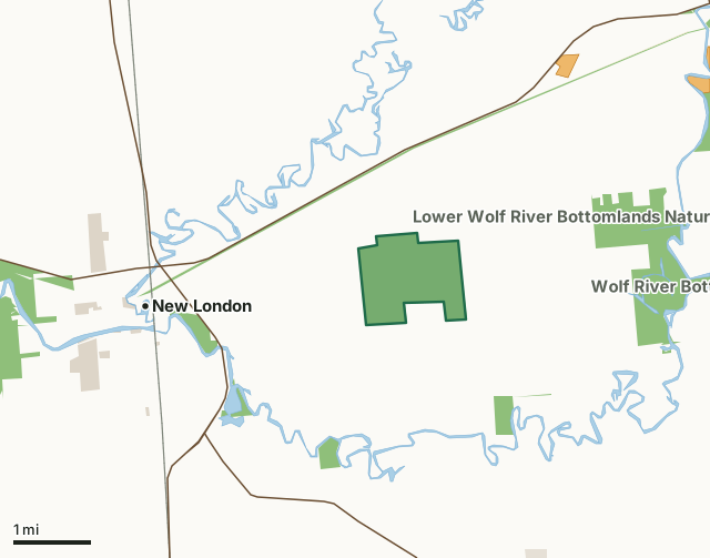
State wildlife areas, forests and other DNR landState parksOther county, city and regional landLand trusts and other open landVoluntary Public Access landHortonville Bog State Natural AreaCounty lineLakeHighway
| Size | 794 acres |
|---|---|
| County | Outagamie County |
| Deer Management Unit | Outagamie County |
| Public access (DNR) | Open to Hiking, Fishing, Hunting and Trapping |
| DNR property page | Hortonville Bog |
| Nearest towns | New London (3 mi), Hortonville (4 mi) and Shiocton (5 mi) |
What is Hortonville Bog State Natural Area like?
Hortonville Bog is one of the best bogs in southern Wisconsin and contains an open ericaceous bog with a very deep sphagnum layer. Dominants are leather-leaf and Labrador-tea. Poison sumac is abundant throughout the site. Although there is no open water, the bog is very spongy. Surrounding the bog is an advancing ring of tamarack and black spruce in all age and size classes. To the south is a wet-mesic forest dominated by tamarack and white cedar. The bog contains several species of birds indicative of northern bog communities: winter wren, Canada warbler, Nashville warbler, white-throated sparrow, sharp-shinned hawk, northern waterthrush, and Lincoln's sparrow. Hortonville Bog is owned by the DNR and was designated a State Natural Area in 1987. A compass, topographic map, or GPS unit are useful tools for exploring larger, isolated SNAs.
A GPS unit or compass and a detailed topographic map are valuable tools for exploring larger SNAs. Outagamie County. T22N-R15E, Sections 2, 3, 9, 10, 11. 1,299 acres. From the intersection of County S and U.S. Highway 45 in New London, go east on S 2.65 miles, then north on Allcan Road 0.4 miles to the 90-degree turn and DNR parking area. walk northeast into the bog (0.15 miles). Hortonville Bog is owned by: Private and the Wisconsin DNR.
In the DNR's words, from its page for the property.
What are the rules on Hortonville Bog State Natural Area?
The DNR's property map lists Hortonville Bog State Natural Area as "Open to Hiking, Fishing, Hunting and Trapping". Hunting follows Wisconsin's statewide seasons and the rules posted on the property.
How many deer are taken around Hortonville Bog State Natural Area?
Hortonville Bog State Natural Area lies in Outagamie County. The DNR registered 4,322 deer in Outagamie County in 2025, against 4,318 in 2024.
| DMU | Hortonville Bog State Natural Area acres in it | Deer, 2025 | Deer, 2024 | Deer, 2023 |
|---|---|---|---|---|
| Outagamie County | 794 | 4,322 | 4,318 | 3,847 |
Harvest for the whole deer management unit, not the property alone: Wisconsin DNR Deer Metrics (registered harvest by deer management unit).
How do you get to Hortonville Bog State Natural Area?
Nearest towns: New London (3 miles), Hortonville (4 miles), Shiocton (5 miles) and Northport (6 miles). Highways within 5 miles: WI 54, US 45, WI 15 and WI 76. 1 VPA property within 3 miles.
What other public land is near Hortonville Bog State Natural Area?
DNR properties within 10 miles:
- Newton Blackmour State Trail: 286 acres, 0.8 miles away
- Lower Wolf River Bottomlands Natural Resource Area: 3,670 acres, 1 mile away
- Wolf River Bottoms Wildlife Area: 3,142 acres, 2.2 miles away
- Wolf River Fishery Area: 205 acres, 3.7 miles away
Public land within 3 miles of Hortonville Bog State Natural Area
Counting Hortonville Bog State Natural Area itself, 1,965 of the 27,909 acres within 3 miles of its boundary are public land open to the public (7%), by USGS PAD-US 4.1 (fee land open to the public).
| Manager | Acres within 3 miles |
|---|---|
| State wildlife areas, forests and other DNR land | 1,949 |
| Other county, city and regional land | 13 |
| State parks | 3 |
Questions hunters ask
Where is Hortonville Bog State Natural Area?
In Outagamie County, 3 miles from New London. The DNR's property page has its maps and parking.
Is Hortonville Bog State Natural Area open to hunting?
Yes. The DNR's property map lists it as "Open to Hiking, Fishing, Hunting and Trapping". Posted refuges or closed areas, where there are any, are marked on site.
Which deer management unit is Hortonville Bog State Natural Area in?
Outagamie County.
How much public land is around Hortonville Bog State Natural Area?
1,965 acres within 3 miles of its boundary, Hortonville Bog State Natural Area included, by PAD-US 4.1. The closest other DNR property is Newton Blackmour State Trail (0.8 miles).
Get a Wisconsin hunt plan when they open
Hunt plans for Wisconsin are coming. Join the list and you'll hear first. The first 50 hunters in each new state get their plan free.
Until then, the free FilledTag app for iPhone has a map that works in every state, Wisconsin included.
Where these facts come from
- Area description, species, rules and directions: DNR, Hortonville Bog State Natural Area; Wisconsin DNR managed lands open to hunting.
- Boundary and acres: the DNR's map layer above. Surrounding public land: USGS PAD-US 4.1 (fee land open to the public).
- Deer harvest: Wisconsin DNR Deer Metrics (registered harvest by deer management unit).
FilledTag is not part of the Wisconsin Department of Natural Resources. Check the DNR's rules and posted signs before you go.