Kimberly Clark Wildlife Area: hunting and access
Kimberly Clark Wildlife Area is 8,742 acres of land managed by the Wisconsin DNR in Price County, 9 miles from Phillips. The DNR's page for it names deer, wild turkey and ruffed grouse among the game here. Hunters registered 1,398 deer in DMU 112 in 2025.
Data updated October 2026. Area facts: the DNR's DNR property data, read 2026-10. Harvest: DNR Deer Metrics.
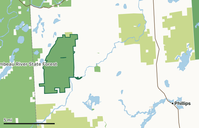
State wildlife areas, forests and other DNR landCounty forestNational forestOther federal landLand trusts and other open landKimberly Clark Wildlife AreaCounty lineLakeHighway
| Size | 8,742 acres in 2 pieces |
|---|---|
| County | Price County |
| Deer Management Unit | DMU 112, DMU 115 |
| DNR lists for hunting | deer, wild turkey and ruffed grouse |
| Public access (DNR) | Open to Hiking, Fishing, Hunting and Trapping |
| DNR property page | Kimberly Clark Wildlife Area |
| Nearest towns | Phillips (9 mi), Park Falls (12 mi) and Kennan (13 mi) |
What is Kimberly Clark Wildlife Area like?
Kimberly Clark Wildlife Area is a 8,700-acre property located 12 miles west of Phillips in Price County. The property is known for its highly diverse habitat mix on a large scale. Thousands of acres each of grasslands, hardwoods, conifer bogs and various wetlands are arranged throughout the property. About 2/3 of the property is actively managed for wildlife production and public usage. Though Kimberly Clark Wildlife Area is large in size, it has excellent access via a seasonally open road running from Price Lakes Road to Up River Road. This road has seen extensive recent upgrades that will enhance public access throughout the fall and early winter. The South Fork of the Flambeau River is also accessible from the southeastern area of the property.
Because of the wide variety and size of habitat available on Kimberly Clark Wildlife Area, consumptive and non-consumptive uses are numerous. From turkey hunting in the spring, foraging in the summer, ruffed grouse hunting in the fall, or snowshoeing in the winter there’s always something to do on this property. Find Kimberly Clark Wildlife Area by taking County Highway W west of Phillips for 12 miles, then north on Up River Road, or 16.5 miles and then north on Price Lakes Road. This wildlife area dates back to 1945 with the purchase of the original 1,600 acres of land as part of the "deer yard" program, which was developed to save and manage overwinter deer habitat. It was known then as the Price Creek deer yard. In 1963, the DNR received a gift of 5,240 acres near the deer yard from the Kimberly-Clark Corp. This is when the property became known as Kimberly Clark Wildlife Area.
In the DNR's words, from its page for the property.
What can you hunt on Kimberly Clark Wildlife Area?
The DNR's page for Kimberly Clark Wildlife Area names deer, wild turkey and ruffed grouse. Each follows Wisconsin's statewide season and, for deer, the tags and rules of the deer management unit.
What are the rules on Kimberly Clark Wildlife Area?
The DNR's property map lists Kimberly Clark Wildlife Area as "Open to Hiking, Fishing, Hunting and Trapping". Hunting follows Wisconsin's statewide seasons and the rules posted on the property.
Activities the DNR lists for Kimberly Clark Wildlife Area: Auto travel (from Nov. 1st until breakup), Hiking, Birding, Boating (non-motorized), Canoeing, Cross-country skiing (no designated trail), Fishing, Hiking (no designated trail), Hunting (noted for: deer, ruffed grouse and wild turkey), Kayaking, Snowshoeing (no designated trail), Trapping, Wild edibles/gathering and Wild rice harvesting.
How many deer are taken around Kimberly Clark Wildlife Area?
Kimberly Clark Wildlife Area lies in 2 deer management units. The DNR registered 1,398 deer in DMU 112 in 2025.
| DMU | Kimberly Clark Wildlife Area acres in it | Deer, 2025 |
|---|---|---|
| DMU 112 | 8,733 | 1,398 |
| DMU 115 | 9 | 3,013 |
Harvest for the whole deer management unit, not the property alone: Wisconsin DNR Deer Metrics (registered harvest by deer management unit).
How do you get to Kimberly Clark Wildlife Area?
Nearest towns: Phillips (9 miles), Park Falls (12 miles), Kennan (13 miles) and Catawba (13 miles). Highways within 5 miles: WI 70.
What other public land is near Kimberly Clark Wildlife Area?
DNR properties within 10 miles:
- Flambeau River State Forest: 89,904 acres, 0.5 miles away
- Niebauer Springs Fishery Area: 199 acres, 1.3 miles away
- Lac Sault Dore State Public Access: 24 acres, 3 miles away
- Carpenter Creek Conservation Easement Area: 48 acres, 4.7 miles away
- Tuscobia State Trail: 1,087 acres, 7.6 miles away
Public land within 3 miles of Kimberly Clark Wildlife Area
Counting Kimberly Clark Wildlife Area itself, 23,563 of the 60,522 acres within 3 miles of its boundary are public land open to the public (38.9%), by USGS PAD-US 4.1 (fee land open to the public).
| Manager | Acres within 3 miles |
|---|---|
| State wildlife areas, forests and other DNR land | 19,993 |
| County forest | 3,559 |
| Other federal land | 11 |
Questions hunters ask
Where is Kimberly Clark Wildlife Area?
In Price County, 9 miles from Phillips. The DNR's property page has its maps and parking.
Is Kimberly Clark Wildlife Area open to hunting?
Yes. The DNR's property map lists it as "Open to Hiking, Fishing, Hunting and Trapping". Posted refuges or closed areas, where there are any, are marked on site.
Which deer management unit is Kimberly Clark Wildlife Area in?
DMU 112 (8,733 acres) and DMU 115 (9 acres).
How much public land is around Kimberly Clark Wildlife Area?
23,563 acres within 3 miles of its boundary, Kimberly Clark Wildlife Area included, by PAD-US 4.1. The closest other DNR property is Flambeau River State Forest (0.5 miles).
Get a Wisconsin hunt plan when they open
Hunt plans for Wisconsin are coming. Join the list and you'll hear first. The first 50 hunters in each new state get their plan free.
Until then, the free FilledTag app for iPhone has a map that works in every state, Wisconsin included.
Where these facts come from
- Area description, species, rules and directions: DNR, Kimberly Clark Wildlife Area; Wisconsin DNR managed lands open to hunting.
- Boundary and acres: the DNR's map layer above. Surrounding public land: USGS PAD-US 4.1 (fee land open to the public).
- Deer harvest: Wisconsin DNR Deer Metrics (registered harvest by deer management unit).
FilledTag is not part of the Wisconsin Department of Natural Resources. Check the DNR's rules and posted signs before you go.