Lake Helane State Natural Area: hunting and access
Lake Helane State Natural Area is 391 acres of land managed by the Wisconsin DNR in Sawyer County, 5 miles from Cable. Hunters registered 1,776 deer in DMU 113 in 2025.
Data updated October 2026. Area facts: the DNR's DNR property data, read 2026-10. Harvest: DNR Deer Metrics.
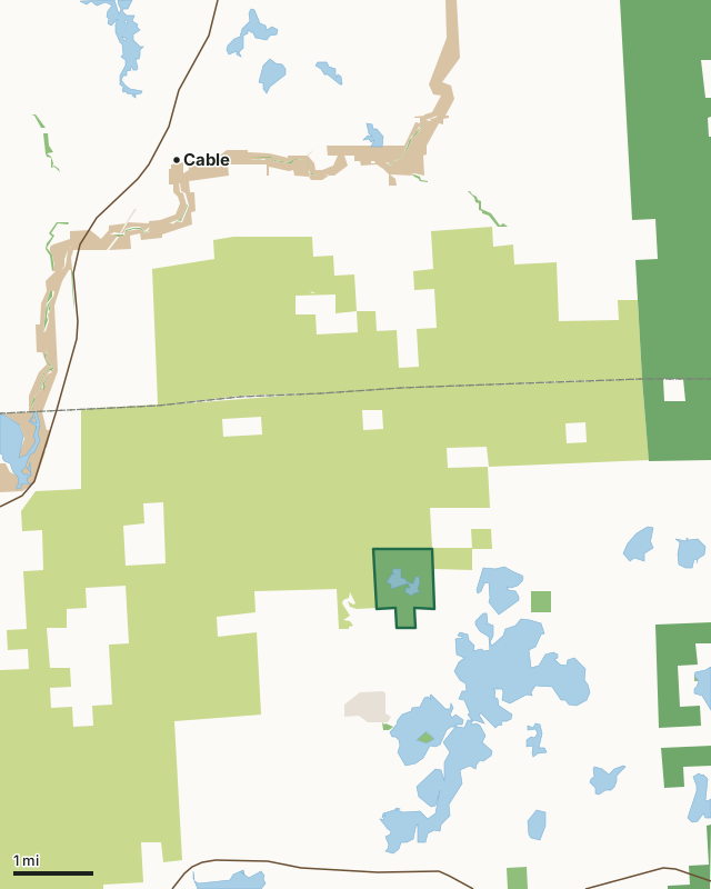
State wildlife areas, forests and other DNR landCounty forestNational forestNational park landOther county, city and regional landLand trusts and other open landLake Helane State Natural AreaCounty lineLakeHighway
| Size | 391 acres |
|---|---|
| County | Sawyer County |
| Deer Management Unit | DMU 113 |
| Public access (DNR) | Open to Hiking, Fishing, Hunting and Trapping |
| DNR property page | Lake Helane |
| Nearest towns | Cable (5 mi), Little Round Lake (12 mi) and Chief Lake (13 mi) |
What is Lake Helane State Natural Area like?
The feature of this site is Lake Helane, an undeveloped, soft-water seepage lake with two separate basins and a navigable channel connecting the two. The 51-acre lake has a maximum depth of 27 feet and a sand and gravel bottom with the very good water clarity. The lake is fringed with a narrow belt of northern dry-mesic forest dominated by red and white pine. Surrounding the lake are scattered boggy wetlands containing leatherleaf, cranberry, and various sedges. Breeding birds include belted kingfisher, olive-sided flycatcher, eastern wood-pewee, alder flycatcher, least flycatcher, veery, Nashville warbler, black and white warbler, mourning warbler, Canada warbler, black-throated blue warbler. Sawyer County Forest surrounds the west and northern boundary. Lake Helane is owned by the DNR and was designated a State Natural Area in 2009. Sawyer County. T42N-R7E, Sections 15, 16. 390 acres.
From the intersection of Highways 77 and 63 in Hayward, go east on 77 for 12.5 miles, then north on North Murphy Blvd. 2.2 miles, then north and east nearly 2 miles to the lake.
In the DNR's words, from its page for the property.
What are the rules on Lake Helane State Natural Area?
The DNR's property map lists Lake Helane State Natural Area as "Open to Hiking, Fishing, Hunting and Trapping". Hunting follows Wisconsin's statewide seasons and the rules posted on the property.
How many deer are taken around Lake Helane State Natural Area?
Lake Helane State Natural Area lies in DMU 113. The DNR registered 1,776 deer in DMU 113 in 2025.
| DMU | Lake Helane State Natural Area acres in it | Deer, 2025 |
|---|---|---|
| DMU 113 | 391 | 1,776 |
Harvest for the whole deer management unit, not the property alone: Wisconsin DNR Deer Metrics (registered harvest by deer management unit).
How do you get to Lake Helane State Natural Area?
Nearest towns: Cable (5 miles), Little Round Lake (12 miles), Chief Lake (13 miles) and Hayward (14 miles). Highways within 5 miles: WI 77 and US 63.
What other public land is near Lake Helane State Natural Area?
DNR properties within 10 miles:
- Town of Spider Lake State Habitat Area: 42 acres, 1.2 miles away
Public land within 3 miles of Lake Helane State Natural Area
Counting Lake Helane State Natural Area itself, 11,198 of the 24,591 acres within 3 miles of its boundary are public land open to the public (45.5%), by USGS PAD-US 4.1 (fee land open to the public).
| Manager | Acres within 3 miles |
|---|---|
| County forest | 10,554 |
| State wildlife areas, forests and other DNR land | 453 |
| Land trusts and other open land | 108 |
| National forest | 83 |
Questions hunters ask
Where is Lake Helane State Natural Area?
In Sawyer County, 5 miles from Cable. The DNR's property page has its maps and parking.
Is Lake Helane State Natural Area open to hunting?
Yes. The DNR's property map lists it as "Open to Hiking, Fishing, Hunting and Trapping". Posted refuges or closed areas, where there are any, are marked on site.
Which deer management unit is Lake Helane State Natural Area in?
DMU 113.
How much public land is around Lake Helane State Natural Area?
11,198 acres within 3 miles of its boundary, Lake Helane State Natural Area included, by PAD-US 4.1. The closest other DNR property is Town of Spider Lake State Habitat Area (1.2 miles).
Get a Wisconsin hunt plan when they open
Hunt plans for Wisconsin are coming. Join the list and you'll hear first. The first 50 hunters in each new state get their plan free.
Until then, the free FilledTag app for iPhone has a map that works in every state, Wisconsin included.
Where these facts come from
- Area description, species, rules and directions: DNR, Lake Helane State Natural Area; Wisconsin DNR managed lands open to hunting.
- Boundary and acres: the DNR's map layer above. Surrounding public land: USGS PAD-US 4.1 (fee land open to the public).
- Deer harvest: Wisconsin DNR Deer Metrics (registered harvest by deer management unit).
FilledTag is not part of the Wisconsin Department of Natural Resources. Check the DNR's rules and posted signs before you go.