Lake Mills Wildlife Area: hunting and access
Lake Mills Wildlife Area is 2,674 acres of land managed by the Wisconsin DNR in Jefferson County, 2 miles from Lake Mills. The DNR's page for it names deer, wild turkey, pheasants, ducks and geese and small game among the game here. Hunters registered 3,843 deer in Jefferson County in 2025.
Data updated October 2026. Area facts: the DNR's DNR property data, read 2026-10. Harvest: DNR Deer Metrics.
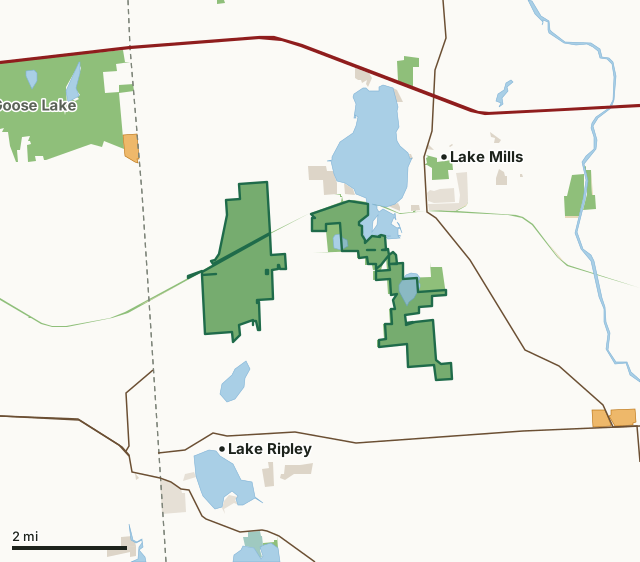
State wildlife areas, forests and other DNR landNational wildlife refuges and waterfowl production areasState parksOther county, city and regional landLand trusts and other open landVoluntary Public Access landLake Mills Wildlife AreaCounty lineLakeHighway
| Size | 2,674 acres in 6 pieces |
|---|---|
| County | Jefferson County |
| Deer Management Unit | Jefferson County |
| DNR lists for hunting | deer, wild turkey, pheasants, ducks and geese and small game |
| Public access (DNR) | Open to Hiking, Fishing, Hunting and Trapping |
| DNR property page | Lake Mills Wildlife Area |
| Nearest towns | Lake Mills (2 mi), Lake Ripley (2 mi) and Cambridge (3 mi) |
What is Lake Mills Wildlife Area like?
Lake Mills Wildlife Area is comprised of a diverse variety of habitat types covering approximately 2,800 acres. The habitat types include open water marsh, large areas of wet prairie, lowland hardwoods with tamarack, and some oak savanna uplands. There is an excellent opportunity for hunting waterfowl, pheasant, deer, and small game. This wildlife area is divided into two separate units. The eastern Lake Mills unit is primarily comprised of wetlands, including parts of three lakes (Rock Lake, Bean Lake and Mud Lake), extensive shrub-carr and southern tamarack swamp and some uplands with oak savanna and other hardwoods. This unit contains Bean Lake State Natural Area and the Mud Lake Fen and Wet Prairie State Natural Area. Also, there is an 80-acre class II dog training and trialing area.
The western Zeloski Marsh unit, which is part of the former, larger London Marsh, is comprised of restored wetlands with impoundments that provide opportunities to manage water levels for migrating and nesting waterfowl, shorebirds, and other wetland species. Large portions of the area have been planted with wet to mesic prairie species. The Zeloski Marsh unit contains several miles of dike-top access lanes maintained for management purposes, which provide excellent opportunities for walking, wildlife watching, and hunting. The Zeloski Unit was acquired by the Southern Wisconsin Bird Alliance (formerly Madison Audubon and donated to the Department in 2006. It was restored from agricultural drainage as part of the Federal Wetland Restoration Easement (WRE) program.
In the DNR's words, from its page for the property.
What can you hunt on Lake Mills Wildlife Area?
The DNR's page for Lake Mills Wildlife Area names deer, wild turkey, pheasants, ducks and geese and small game. Each follows Wisconsin's statewide season and, for deer, the tags and rules of the deer management unit.
What are the rules on Lake Mills Wildlife Area?
The DNR's property map lists Lake Mills Wildlife Area as "Open to Hiking, Fishing, Hunting and Trapping". Hunting follows Wisconsin's statewide seasons and the rules posted on the property.
Activities the DNR lists for Lake Mills Wildlife Area: Biking, Birding, Canoeing, Cross-country skiing (no designated trail), Fishing, Hiking (designated trail), Hunting (especially noted for waterfowl, pheasant, deer, turkey and small game), Snowmobiling (designated trails only), Kayaking, Trapping, Wild edibles/gathering ( What can I collect? } and Wildlife viewing.
How many deer are taken around Lake Mills Wildlife Area?
Lake Mills Wildlife Area lies in Jefferson County. The DNR registered 3,843 deer in Jefferson County in 2025, against 3,816 in 2024.
| DMU | Lake Mills Wildlife Area acres in it | Deer, 2025 | Deer, 2024 | Deer, 2023 |
|---|---|---|---|---|
| Jefferson County | 2,674 | 3,843 | 3,816 | 3,579 |
Harvest for the whole deer management unit, not the property alone: Wisconsin DNR Deer Metrics (registered harvest by deer management unit).
How do you get to Lake Mills Wildlife Area?
Nearest towns: Lake Mills (2 miles), Lake Ripley (2 miles), Cambridge (3 miles) and Deerfield (4 miles). Highways within 5 miles: I-94, WI 89, US 18, US 12 and WI 26. 2 VPA properties within 3 miles.
What other public land is near Lake Mills Wildlife Area?
DNR properties within 10 miles:
- Glacial Drumlin State Trail: 1,021 acres, next to it
- Lake Mills Hatchery: 80 acres, 1.2 miles away
- Goose Lake Wildlife Area: 2,463 acres, 2 miles away
- Aztalan State Park: 178 acres, 2.4 miles away
- Red Cedar Lake State Natural Area: 49 acres, 3.9 miles away
Public land within 3 miles of Lake Mills Wildlife Area
Counting Lake Mills Wildlife Area itself, 4,567 of the 49,781 acres within 3 miles of its boundary are public land open to the public (9.2%), by USGS PAD-US 4.1 (fee land open to the public).
| Manager | Acres within 3 miles |
|---|---|
| State wildlife areas, forests and other DNR land | 3,932 |
| Other county, city and regional land | 328 |
| Land trusts and other open land | 287 |
| State parks | 20 |
Questions hunters ask
Where is Lake Mills Wildlife Area?
In Jefferson County, 2 miles from Lake Mills. The DNR's property page has its maps and parking.
Is Lake Mills Wildlife Area open to hunting?
Yes. The DNR's property map lists it as "Open to Hiking, Fishing, Hunting and Trapping". Posted refuges or closed areas, where there are any, are marked on site.
Which deer management unit is Lake Mills Wildlife Area in?
Jefferson County.
How much public land is around Lake Mills Wildlife Area?
4,567 acres within 3 miles of its boundary, Lake Mills Wildlife Area included, by PAD-US 4.1. The closest other DNR property is Glacial Drumlin State Trail (next to it).
Get a Wisconsin hunt plan when they open
Hunt plans for Wisconsin are coming. Join the list and you'll hear first. The first 50 hunters in each new state get their plan free.
Until then, the free FilledTag app for iPhone has a map that works in every state, Wisconsin included.
Where these facts come from
- Area description, species, rules and directions: DNR, Lake Mills Wildlife Area; Wisconsin DNR managed lands open to hunting.
- Boundary and acres: the DNR's map layer above. Surrounding public land: USGS PAD-US 4.1 (fee land open to the public).
- Deer harvest: Wisconsin DNR Deer Metrics (registered harvest by deer management unit).
FilledTag is not part of the Wisconsin Department of Natural Resources. Check the DNR's rules and posted signs before you go.