Lehto Lake State Natural Area: hunting and access
Lehto Lake State Natural Area is 1,624 acres of land managed by the Wisconsin DNR in Iron County, 7 miles from Lac du Flambeau. Hunters registered 895 deer in DMU 117 in 2025.
Data updated October 2026. Area facts: the DNR's DNR property data, read 2026-10. Harvest: DNR Deer Metrics.
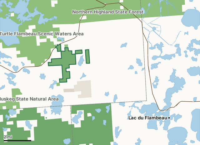
State wildlife areas, forests and other DNR landNational forestOther county, city and regional landLand trusts and other open landLehto Lake State Natural AreaCounty lineLakeHighway
| Size | 1,624 acres in 5 pieces |
|---|---|
| County | Iron County |
| Deer Management Unit | DMU 117 |
| Public access (DNR) | Open to Hiking, Fishing, Hunting and Trapping |
| DNR property page | Lehto Lake |
| Nearest towns | Lac du Flambeau (7 mi), Mercer (8 mi) and Woodruff (18 mi) |
What is Lehto Lake State Natural Area like?
Lehto Lake features an extensive peatland complex associated with Randall Creek, a slow, soft, warm water stream tributary to the Bear River. From the outlet on Randall Lake to the Bear River, this seasonally navigable stream is bordered by extensive stands of northern sedge meadow and shrub swamp/fen thickets. Scattered islands of second-growth pine and paper birch occur next to the creek and out in the open bog areas. The edges of this peatland are dominated by closed-canopy black spruce swamp grading into a narrow zone of white cedar along the upland margin. The peatlands north and west of Lehto Lake support swamp islands of dense second-growth fire-origin hemlock-white pine forest under an overstory of old paper birch. A small but outstanding old-growth hemlock stand with super canopy white pine occurs along the south shore of Lehto Lake.
Iron County. T41N-R3E, Section 25. T41N-R3E, Sections 12, 13, 25. T41N-R4E, Sections 7, 17, 18, 19, 30. 1,612 acres. Access is via canoe from the boat landing on Randall Lake to Randall Creek.
In the DNR's words, from its page for the property.
What are the rules on Lehto Lake State Natural Area?
The DNR's property map lists Lehto Lake State Natural Area as "Open to Hiking, Fishing, Hunting and Trapping". Hunting follows Wisconsin's statewide seasons and the rules posted on the property.
How many deer are taken around Lehto Lake State Natural Area?
Lehto Lake State Natural Area lies in DMU 117. The DNR registered 895 deer in DMU 117 in 2025.
| DMU | Lehto Lake State Natural Area acres in it | Deer, 2025 |
|---|---|---|
| DMU 117 | 1,624 | 895 |
Harvest for the whole deer management unit, not the property alone: Wisconsin DNR Deer Metrics (registered harvest by deer management unit).
How do you get to Lehto Lake State Natural Area?
Nearest towns: Lac du Flambeau (7 miles), Mercer (8 miles), Woodruff (18 miles) and Minocqua (18 miles). Highways within 5 miles: WI 182 and WI 47.
What other public land is near Lehto Lake State Natural Area?
DNR properties within 10 miles:
- Turtle Flambeau Scenic Waters Area: 35,782 acres, next to it
- Northern Highland State Forest: 176,323 acres, 1.5 miles away
- Springstead Muskeg State Natural Area: 632 acres, 2.7 miles away
- Powell Marsh Wildlife Area: 4,347 acres, 4.2 miles away
Public land within 3 miles of Lehto Lake State Natural Area
Counting Lehto Lake State Natural Area itself, 12,670 of the 39,032 acres within 3 miles of its boundary are public land open to the public (32.5%), by USGS PAD-US 4.1 (fee land open to the public).
| Manager | Acres within 3 miles |
|---|---|
| State wildlife areas, forests and other DNR land | 10,377 |
| National forest | 1,348 |
| Land trusts and other open land | 822 |
| Other county, city and regional land | 123 |
Questions hunters ask
Where is Lehto Lake State Natural Area?
In Iron County, 7 miles from Lac du Flambeau. The DNR's property page has its maps and parking.
Is Lehto Lake State Natural Area open to hunting?
Yes. The DNR's property map lists it as "Open to Hiking, Fishing, Hunting and Trapping". Posted refuges or closed areas, where there are any, are marked on site.
Which deer management unit is Lehto Lake State Natural Area in?
DMU 117.
How much public land is around Lehto Lake State Natural Area?
12,670 acres within 3 miles of its boundary, Lehto Lake State Natural Area included, by PAD-US 4.1. The closest other DNR property is Turtle Flambeau Scenic Waters Area (next to it).
Get a Wisconsin hunt plan when they open
Hunt plans for Wisconsin are coming. Join the list and you'll hear first. The first 50 hunters in each new state get their plan free.
Until then, the free FilledTag app for iPhone has a map that works in every state, Wisconsin included.
Where these facts come from
- Area description, species, rules and directions: DNR, Lehto Lake State Natural Area; Wisconsin DNR managed lands open to hunting.
- Boundary and acres: the DNR's map layer above. Surrounding public land: USGS PAD-US 4.1 (fee land open to the public).
- Deer harvest: Wisconsin DNR Deer Metrics (registered harvest by deer management unit).
FilledTag is not part of the Wisconsin Department of Natural Resources. Check the DNR's rules and posted signs before you go.