Lulu Lake Lulu Natural Area: hunting and access
Lulu Lake Lulu Natural Area is 1,973 acres of land managed by the Wisconsin DNR in Walworth and Waukesha counties, 2 miles from Eagle. Hunters registered 2,132 deer in Walworth County in 2025.
Data updated October 2026. Area facts: the DNR's DNR property data, read 2026-10. Harvest: DNR Deer Metrics.
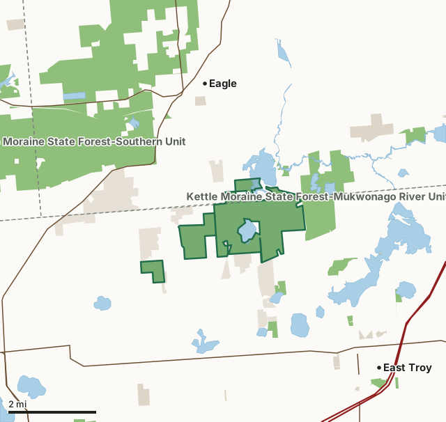
State wildlife areas, forests and other DNR landOther federal landOther county, city and regional landLand trusts and other open landLulu Lake Lulu Natural AreaCounty lineLakeHighway
| Size | 1,973 acres in 4 pieces |
|---|---|
| Counties | Walworth County and Waukesha County |
| Deer Management Unit | Walworth County, Waukesha County |
| Public access (DNR) | Open to Hiking, Fishing, Hunting and Trapping |
| DNR property page | Lulu Lake |
| Nearest towns | Eagle (2 mi), East Troy (3 mi) and Potter Lake (4 mi) |
What is Lulu Lake Lulu Natural Area like?
Lulu Lake, a slow, no-wake lake features an assemblage of exceptionally high-quality and diverse wetland and upland communities on glacial topography in the Kettle Moraine region. Many of the natural communities protected here have been virtually eliminated from southeastern Wisconsin. The focal point of the area is the 95-acre Lulu Lake, a 40-foot deep, hard water drainage kettle lake fed by the Mukwonago River and situated at the base of glacial deposits. A large wetland complex with patches of calcareous fen and shrub carr embedded within a sedge meadow matrix surrounds the lake on the north and west. An inlet stream contains many rare fen species. A small bog surrounded by tamarack forest is also present along with a good complement of other bog species typically found further north. Scattered patches of prairie grow within the oak opening and woodlands.
Walworth and Waukesha Counties. T4N-R17E, Sections 1, 2, 3, 10, 11, 12. T5N-R17E, Sections 35, 36. 1,866 acres (DNR=1,238 and TNC=627). The natural area can be accessed by land from the east, west, and south and by the water. For southern access: From the intersection of County Highways N and J in Troy Center (4.5 miles northwest of East Troy), go east on J 1.2 miles to a parking area north of the road. For eastern access: From the intersection of Highways N and J, go east on J for 2.2 miles, then go north on County Highway E 0.3 miles to a parking lot west of the road. For the western access: From the intersection of Highways N and J and Bluff Road in Troy Center, go north on Bluff Road for 0.5 miles, then continue north on Nature Road for 0.9 miles to a parking lot west of the road.
In the DNR's words, from its page for the property.
What are the rules on Lulu Lake Lulu Natural Area?
The DNR's property map lists Lulu Lake Lulu Natural Area as "Open to Hiking, Fishing, Hunting and Trapping". Hunting follows Wisconsin's statewide seasons and the rules posted on the property.
How many deer are taken around Lulu Lake Lulu Natural Area?
Lulu Lake Lulu Natural Area lies in 2 deer management units. The DNR registered 2,132 deer in Walworth County in 2025, against 2,059 in 2024.
| DMU | Lulu Lake Lulu Natural Area acres in it | Deer, 2025 | Deer, 2024 | Deer, 2023 |
|---|---|---|---|---|
| Walworth County | 1,731 | 2,132 | 2,059 | 1,881 |
| Waukesha County | 243 | 3,320 | 3,021 | 2,888 |
Harvest for the whole deer management unit, not the property alone: Wisconsin DNR Deer Metrics (registered harvest by deer management unit).
How do you get to Lulu Lake Lulu Natural Area?
Nearest towns: Eagle (2 miles), East Troy (3 miles), Potter Lake (4 miles) and Mukwonago (5 miles). Highways within 5 miles: I-43, WI 67, WI 20, WI 59 and US 12.
What other public land is near Lulu Lake Lulu Natural Area?
DNR properties within 10 miles:
- Kettle Moraine State Forest-Mukwonago River Unit: 986 acres, next to it
- Beulah Bog State Natural Area: 78 acres, 1 mile away
- Kettle Moraine State Forest-Southern Unit: 21,556 acres, 1.5 miles away
- Mukwonago River SHA: 150 acres, 2.7 miles away
- Troy State Habitat Area: 590 acres, 3.4 miles away
Public land within 3 miles of Lulu Lake Lulu Natural Area
Counting Lulu Lake Lulu Natural Area itself, 6,841 of the 39,507 acres within 3 miles of its boundary are public land open to the public (17.3%), by USGS PAD-US 4.1 (fee land open to the public).
| Manager | Acres within 3 miles |
|---|---|
| State wildlife areas, forests and other DNR land | 5,044 |
| Land trusts and other open land | 1,411 |
| Other county, city and regional land | 384 |
| Other federal land | 2 |
Questions hunters ask
Where is Lulu Lake Lulu Natural Area?
In Walworth and Waukesha counties, 2 miles from Eagle. The DNR's property page has its maps and parking.
Is Lulu Lake Lulu Natural Area open to hunting?
Yes. The DNR's property map lists it as "Open to Hiking, Fishing, Hunting and Trapping". Posted refuges or closed areas, where there are any, are marked on site.
Which deer management unit is Lulu Lake Lulu Natural Area in?
Walworth County (1,731 acres) and Waukesha County (243 acres).
How much public land is around Lulu Lake Lulu Natural Area?
6,841 acres within 3 miles of its boundary, Lulu Lake Lulu Natural Area included, by PAD-US 4.1. The closest other DNR property is Kettle Moraine State Forest-Mukwonago River Unit (next to it).
Get a Wisconsin hunt plan when they open
Hunt plans for Wisconsin are coming. Join the list and you'll hear first. The first 50 hunters in each new state get their plan free.
Until then, the free FilledTag app for iPhone has a map that works in every state, Wisconsin included.
Where these facts come from
- Area description, species, rules and directions: DNR, Lulu Lake Lulu Natural Area; Wisconsin DNR managed lands open to hunting.
- Boundary and acres: the DNR's map layer above. Surrounding public land: USGS PAD-US 4.1 (fee land open to the public).
- Deer harvest: Wisconsin DNR Deer Metrics (registered harvest by deer management unit).
FilledTag is not part of the Wisconsin Department of Natural Resources. Check the DNR's rules and posted signs before you go.
Wisconsin hunting Walworth County Waukesha County Walworth County Waukesha County