McKenzie Creek Wildlife Area: hunting and access
McKenzie Creek Wildlife Area is 5,547 acres of land managed by the Wisconsin DNR in Polk County, 5 miles from Lewis. The DNR's page for it names deer, wild turkey, ruffed grouse and bear among the game here. Hunters registered 8,091 deer in Polk County in 2025.
Data updated October 2026. Area facts: the DNR's DNR property data, read 2026-10. Harvest: DNR Deer Metrics.
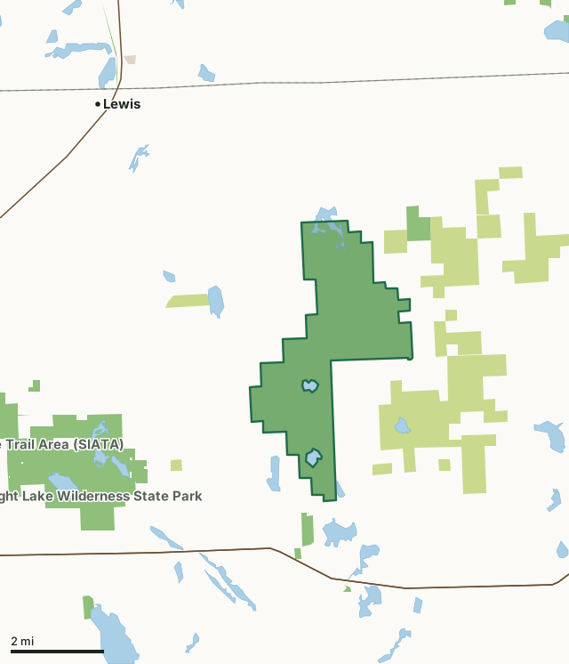
State wildlife areas, forests and other DNR landCounty forestOther county, city and regional landMcKenzie Creek Wildlife AreaCounty lineLakeHighway
| Size | 5,547 acres |
|---|---|
| County | Polk County |
| Deer Management Unit | Polk County |
| DNR lists for hunting | deer, wild turkey, ruffed grouse and bear |
| Public access (DNR) | Open to Hiking, Fishing, Hunting and Trapping |
| DNR property page | McKenzie Creek Wildlife Area |
| Nearest towns | Lewis (5 mi), Frederic (7 mi) and Luck (7 mi) |
What is McKenzie Creek Wildlife Area like?
McKenzie Creek Wildlife Area is a 5,497-acre property in Polk County. It consists of rolling upland aspen, oak, and maple forest, lowland forest, trout streams, lakes, tamarack/black spruce bog and spruce plantation. McKenzie Creek Wildlife Area is 1/2 mile south of Clam Falls. There are access points on 60th and 68th streets, off of Highway I. From Frederic, take Highway W east for 8 miles. The property is north and south of Highway W. From Luck, take Highway 48 east for 8 miles to Highway O. Head north for 2 miles and the property is on the north side of Highway O. There are small gravel parking areas at various locations throughout the property.
Hunting, trapping, fishing, hiking, and wildlife viewing opportunities on this property are endless. Enjoy hiking the Ice Age trail that goes through this area along with the snowmobile trail. This wildlife area is huge, but visitors will have no trouble finding areas to recreate where they can be by themselves and enjoy nature. Also, there are small pull-off areas behind gates for disabled hunters to access with a vehicle. Note: No bikes are allowed on the property, except on roads open to the public for motor vehicles. McKenzie Creek Wildlife Area was established in 1945 for watershed protection, access to four trout streams and because it was a major wintering area for deer. After 2,320 acres were acquired north of Highway W, the project boundary was expanded in 1958 to its current size. The area is popular with hunters, especially ruffed grouse and deer hunters.
In the DNR's words, from its page for the property.
What can you hunt on McKenzie Creek Wildlife Area?
The DNR's page for McKenzie Creek Wildlife Area names deer, wild turkey, ruffed grouse and bear. Each follows Wisconsin's statewide season and, for deer, the tags and rules of the deer management unit.
What are the rules on McKenzie Creek Wildlife Area?
The DNR's property map lists McKenzie Creek Wildlife Area as "Open to Hiking, Fishing, Hunting and Trapping". Hunting follows Wisconsin's statewide seasons and the rules posted on the property.
Activities the DNR lists for McKenzie Creek Wildlife Area: Birding, Boating (non-motorized), Cross-country skiing (no designated trail), Canoeing, Fishing, Hiking (no designated trail), Hunting (noted for deer, bear, grouse and turkey), Kayaking, Snowmobiling trail, Trapping, Wild edibles/gathering and Wildlife viewing.
How many deer are taken around McKenzie Creek Wildlife Area?
McKenzie Creek Wildlife Area lies in Polk County. The DNR registered 8,091 deer in Polk County in 2025, against 7,972 in 2024.
| DMU | McKenzie Creek Wildlife Area acres in it | Deer, 2025 | Deer, 2024 | Deer, 2023 |
|---|---|---|---|---|
| Polk County | 5,547 | 8,091 | 7,972 | 7,275 |
Harvest for the whole deer management unit, not the property alone: Wisconsin DNR Deer Metrics (registered harvest by deer management unit).
How do you get to McKenzie Creek Wildlife Area?
Nearest towns: Lewis (5 miles), Frederic (7 miles), Luck (7 miles) and Siren (8 miles). Highways within 5 miles: WI 46, WI 48 and WI 35.
What other public land is near McKenzie Creek Wildlife Area?
DNR properties within 10 miles:
- State Ice Age Trail Area (SIATA): 4,676 acres, next to it
- Straight River Wildlife Area: 1,500 acres, 2.4 miles away
- Straight Lake Wilderness State Park: 1,631 acres, 2.8 miles away
- Sand Creek Fishery Area-Polk: 1,436 acres, 4.4 miles away
- Frederic Tower Site: 30 acres, 4.5 miles away
Public land within 3 miles of McKenzie Creek Wildlife Area
Counting McKenzie Creek Wildlife Area itself, 11,114 of the 54,589 acres within 3 miles of its boundary are public land open to the public (20.4%), by USGS PAD-US 4.1 (fee land open to the public).
| Manager | Acres within 3 miles |
|---|---|
| State wildlife areas, forests and other DNR land | 6,261 |
| County forest | 4,852 |
| State parks | 1 |
Questions hunters ask
Where is McKenzie Creek Wildlife Area?
In Polk County, 5 miles from Lewis. The DNR's property page has its maps and parking.
Is McKenzie Creek Wildlife Area open to hunting?
Yes. The DNR's property map lists it as "Open to Hiking, Fishing, Hunting and Trapping". Posted refuges or closed areas, where there are any, are marked on site.
Which deer management unit is McKenzie Creek Wildlife Area in?
Polk County.
How much public land is around McKenzie Creek Wildlife Area?
11,114 acres within 3 miles of its boundary, McKenzie Creek Wildlife Area included, by PAD-US 4.1. The closest other DNR property is State Ice Age Trail Area (SIATA) (next to it).
Get a Wisconsin hunt plan when they open
Hunt plans for Wisconsin are coming. Join the list and you'll hear first. The first 50 hunters in each new state get their plan free.
Until then, the free FilledTag app for iPhone has a map that works in every state, Wisconsin included.
Where these facts come from
- Area description, species, rules and directions: DNR, McKenzie Creek Wildlife Area; Wisconsin DNR managed lands open to hunting.
- Boundary and acres: the DNR's map layer above. Surrounding public land: USGS PAD-US 4.1 (fee land open to the public).
- Deer harvest: Wisconsin DNR Deer Metrics (registered harvest by deer management unit).
FilledTag is not part of the Wisconsin Department of Natural Resources. Check the DNR's rules and posted signs before you go.