Moose Lake State Natural Area: hunting and access
Moose Lake State Natural Area is 4,086 acres of land managed by the Wisconsin DNR in Iron County, 7 miles from Mercer. Hunters registered 475 deer in DMU 118 in 2025.
Data updated October 2026. Area facts: the DNR's DNR property data, read 2026-10. Harvest: DNR Deer Metrics.
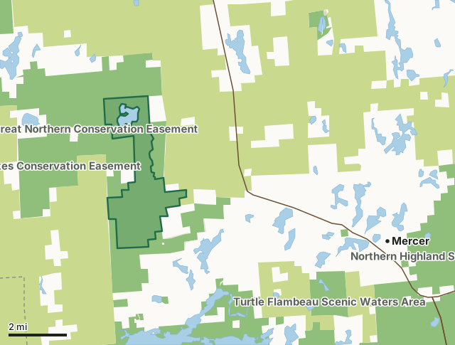
State wildlife areas, forests and other DNR landCounty forestOther county, city and regional landLand trusts and other open landMoose Lake State Natural AreaCounty lineLakeHighway
| Size | 4,086 acres |
|---|---|
| County | Iron County |
| Deer Management Unit | DMU 118 |
| Public access (DNR) | Open to Hiking, Fishing, Hunting and Trapping |
| DNR property page | Moose Lake |
| Nearest towns | Mercer (7 mi), Pence (12 mi) and Iron Belt (12 mi) |
What is Moose Lake State Natural Area like?
Moose Lake is an exceptional example of a large, undeveloped lake in a wilderness setting. The 270 softwater water drainage lake has a maximum depth of 12 feet and harbors a diversity of emergent and submerged aquatic plants. It drains into the 13-acre Little Moose Lake. The fishery contains mostly northern lake fishes including a reproducing population of muskellunge. While a diversity of wetland communities surround the lake, most of the shoreline is covered by a dense thicket of alder and sweet gale; the remainder is predominantly lowland conifer and hardwoods dominated by black spruce, white cedar and black ash. The upland forest surrounding the lake has pockets of higher rocky terrain dominated by sugar maple, basswood, paper birch and balsam fir.
Dominant trees are hemlock and yellow birch, some more than 2 feet in diameter at breast height. White spruce, white cedar, balsam fir, sugar maple and red maple are found occasionally and the ground layer species composition is representative of northern boreal forest. Some dead-standing hemlock and yellow birch accentuate the unmanaged appearance. Hemlock is reproducing as evidenced by seedlings and saplings. Large numbers of wildlife including black bear, hooded merganser and blue-winged teal use the area. Breeding birds include bald eagle and common loon. Moose Lake is owned by the DNR and was designated a State Natural Area in 1992. If a developed trail is present, it will normally be noted on the SNA map or in the Directions tab. Iron County. T43N-R2E, Sections 2, 3, 10, 11, 14, 22, 23, 26, 27. 4,293 acres. For boat access, from the intersection of U.S.
In the DNR's words, from its page for the property.
What are the rules on Moose Lake State Natural Area?
The DNR's property map lists Moose Lake State Natural Area as "Open to Hiking, Fishing, Hunting and Trapping". Hunting follows Wisconsin's statewide seasons and the rules posted on the property.
How many deer are taken around Moose Lake State Natural Area?
Moose Lake State Natural Area lies in DMU 118. The DNR registered 475 deer in DMU 118 in 2025.
| DMU | Moose Lake State Natural Area acres in it | Deer, 2025 |
|---|---|---|
| DMU 118 | 4,086 | 475 |
Harvest for the whole deer management unit, not the property alone: Wisconsin DNR Deer Metrics (registered harvest by deer management unit).
How do you get to Moose Lake State Natural Area?
Nearest towns: Mercer (7 miles), Pence (12 miles), Iron Belt (12 miles) and Montreal (13 miles). Highways within 5 miles: US 51.
What other public land is near Moose Lake State Natural Area?
DNR properties within 10 miles:
- Tomahawk Timberlands Conservation Easement (Moose Lake Trct): 3,017 acres, next to it
- Great Northern Conservation Easement: 14,010 acres, next to it
- Twin Lakes Conservation Easement: 14,007 acres, 0.9 miles away
- Turtle Flambeau Scenic Waters Area: 35,782 acres, 1.8 miles away
Public land within 3 miles of Moose Lake State Natural Area
Counting Moose Lake State Natural Area itself, 37,248 of the 50,634 acres within 3 miles of its boundary are public land open to the public (73.6%), by USGS PAD-US 4.1 (fee land open to the public).
| Manager | Acres within 3 miles |
|---|---|
| County forest | 19,989 |
| State wildlife areas, forests and other DNR land | 17,212 |
| Land trusts and other open land | 47 |
Questions hunters ask
Where is Moose Lake State Natural Area?
In Iron County, 7 miles from Mercer. The DNR's property page has its maps and parking.
Is Moose Lake State Natural Area open to hunting?
Yes. The DNR's property map lists it as "Open to Hiking, Fishing, Hunting and Trapping". Posted refuges or closed areas, where there are any, are marked on site.
Which deer management unit is Moose Lake State Natural Area in?
DMU 118.
How much public land is around Moose Lake State Natural Area?
37,248 acres within 3 miles of its boundary, Moose Lake State Natural Area included, by PAD-US 4.1. The closest other DNR property is Tomahawk Timberlands Conservation Easement (Moose Lake Trct) (next to it).
Get a Wisconsin hunt plan when they open
Hunt plans for Wisconsin are coming. Join the list and you'll hear first. The first 50 hunters in each new state get their plan free.
Until then, the free FilledTag app for iPhone has a map that works in every state, Wisconsin included.
Where these facts come from
- Area description, species, rules and directions: DNR, Moose Lake State Natural Area; Wisconsin DNR managed lands open to hunting.
- Boundary and acres: the DNR's map layer above. Surrounding public land: USGS PAD-US 4.1 (fee land open to the public).
- Deer harvest: Wisconsin DNR Deer Metrics (registered harvest by deer management unit).
FilledTag is not part of the Wisconsin Department of Natural Resources. Check the DNR's rules and posted signs before you go.