Nourse Sugarbush State Natural Area: hunting and access
Nourse Sugarbush State Natural Area is 442 acres of land managed by the Wisconsin DNR in Bayfield County, 4 miles from Bayfield. Hunters registered 1,134 deer in DMU 103 in 2025.
Data updated October 2026. Area facts: the DNR's DNR property data, read 2026-10. Harvest: DNR Deer Metrics.
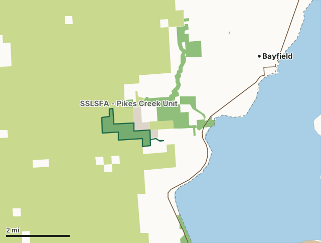
State wildlife areas, forests and other DNR landCounty forestNational park landOther county, city and regional landNourse Sugarbush State Natural AreaCounty lineLakeHighway
| Size | 442 acres in 2 pieces |
|---|---|
| County | Bayfield County |
| Deer Management Unit | DMU 103 |
| Public access (DNR) | Open to Hiking, Fishing, Hunting and Trapping |
| DNR property page | Nourse Sugarbush |
| Nearest towns | Bayfield (4 mi), Washburn (7 mi) and Cornucopia (10 mi) |
What is Nourse Sugarbush State Natural Area like?
Nourse Sugarbush features an old-growth northern mesic forest on the northwest flank of Mt. Ashwabay, a steep-sided hill rising over 700' above Lake Superior. To the south, the land rises abruptly to the Bayfield outwash sands and supports dry forest and barren communities. In contrast, although situated on the same glacial outwash, the sugarbush developed in the shadow of Mt. Ashwabay, which protected it from fire. Large hemlock and sugar maple, some towering 100 feet high, dominate the canopy with associated species of yellow birch, basswood, paper birch, and red oak. The understory is composed of ironwood, sugar maple, and balsam fir. The shrub layer is sparse; ground cover includes wild sarsaparilla, hairy sweet cicely, doll's-eyes, rosy twisted-stalk, intermediate wood fern, partridgeberry, and violets.
Bayfield County. T50N-R4W, Sections 19, 29, 30. T50N-R5W, Sections 24, 25. 438 acres. From Washburn, go north on Highway 13 for 9 miles, then west on Whiting Road for about 3.8 miles, then north on Jammer Hill Road for 0.5 miles. Park along the road. Follow the Bayfield County Chasta ski trail north and east 1.5 miles to the tin shed and cabin located in the heart of Sugarbush. Or from Washburn, go north on Highway 13 for 10 miles, then north on Ski Hill Road for 2 miles to the Ashwabay Ski Center Parking lot. On foot, skis or snowshoe, follow the Sugarbush Trail about 2 miles northwest to the Nourse Sugarbush tin shed and cabin.
In the DNR's words, from its page for the property.
What are the rules on Nourse Sugarbush State Natural Area?
The DNR's property map lists Nourse Sugarbush State Natural Area as "Open to Hiking, Fishing, Hunting and Trapping". Hunting follows Wisconsin's statewide seasons and the rules posted on the property.
How many deer are taken around Nourse Sugarbush State Natural Area?
Nourse Sugarbush State Natural Area lies in DMU 103. The DNR registered 1,134 deer in DMU 103 in 2025.
| DMU | Nourse Sugarbush State Natural Area acres in it | Deer, 2025 |
|---|---|---|
| DMU 103 | 442 | 1,134 |
Harvest for the whole deer management unit, not the property alone: Wisconsin DNR Deer Metrics (registered harvest by deer management unit).
How do you get to Nourse Sugarbush State Natural Area?
Nearest towns: Bayfield (4 miles), Washburn (7 miles), Cornucopia (10 miles) and Bayfront (12 miles). Highways within 5 miles: WI 13.
What other public land is near Nourse Sugarbush State Natural Area?
DNR properties within 10 miles:
- SSLSFA - Pikes Creek Unit: 1,007 acres, next to it
- South Shore Lake Superior Fishery Area: 292 acres, 0.7 miles away
- SSLSFA - Sioux River Unit: 2,299 acres, 2.3 miles away
- Big Bay State Park: 2,527 acres, 6.2 miles away
Public land within 3 miles of Nourse Sugarbush State Natural Area
Counting Nourse Sugarbush State Natural Area itself, 18,196 of the 28,227 acres within 3 miles of its boundary are public land open to the public (64.5%), by USGS PAD-US 4.1 (fee land open to the public).
| Manager | Acres within 3 miles |
|---|---|
| County forest | 16,412 |
| State wildlife areas, forests and other DNR land | 1,587 |
| Other county, city and regional land | 197 |
Questions hunters ask
Where is Nourse Sugarbush State Natural Area?
In Bayfield County, 4 miles from Bayfield. The DNR's property page has its maps and parking.
Is Nourse Sugarbush State Natural Area open to hunting?
Yes. The DNR's property map lists it as "Open to Hiking, Fishing, Hunting and Trapping". Posted refuges or closed areas, where there are any, are marked on site.
Which deer management unit is Nourse Sugarbush State Natural Area in?
DMU 103.
How much public land is around Nourse Sugarbush State Natural Area?
18,196 acres within 3 miles of its boundary, Nourse Sugarbush State Natural Area included, by PAD-US 4.1. The closest other DNR property is SSLSFA - Pikes Creek Unit (next to it).
Get a Wisconsin hunt plan when they open
Hunt plans for Wisconsin are coming. Join the list and you'll hear first. The first 50 hunters in each new state get their plan free.
Until then, the free FilledTag app for iPhone has a map that works in every state, Wisconsin included.
Where these facts come from
- Area description, species, rules and directions: DNR, Nourse Sugarbush State Natural Area; Wisconsin DNR managed lands open to hunting.
- Boundary and acres: the DNR's map layer above. Surrounding public land: USGS PAD-US 4.1 (fee land open to the public).
- Deer harvest: Wisconsin DNR Deer Metrics (registered harvest by deer management unit).
FilledTag is not part of the Wisconsin Department of Natural Resources. Check the DNR's rules and posted signs before you go.