Paul Olson Wildlife Area: hunting and access
Paul Olson Wildlife Area is 3,421 acres of land managed by the Wisconsin DNR in Portage and Wood counties, next to Milladore. The DNR's page for it names ducks and geese among the game here. Hunters registered 8,384 deer in Portage County in 2025.
Data updated October 2026. Area facts: the DNR's DNR property data, read 2026-10. Harvest: DNR Deer Metrics.
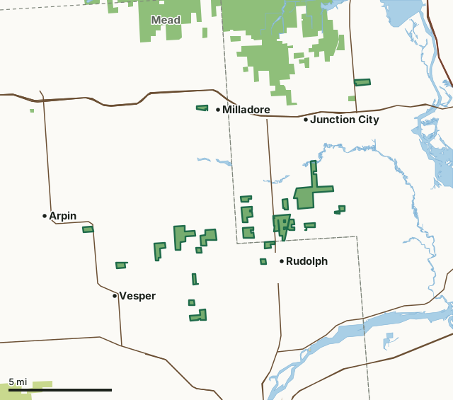
State wildlife areas, forests and other DNR landCounty forestOther federal landOther county, city and regional landPaul Olson Wildlife AreaCounty lineLakeHighway
| Size | 3,421 acres in 24 pieces |
|---|---|
| Counties | Portage County and Wood County |
| Deer Management Unit | Portage County, DMU Wood |
| DNR lists for hunting | ducks and geese |
| Public access (DNR) | Open to Hiking, Fishing, Hunting and Trapping |
| DNR property page | Paul J. Olson Wildlife Area |
| Nearest towns | Milladore (next to it), Rudolph (next to it) and Vesper (next to it) |
What is Paul Olson Wildlife Area like?
Paul J. Olson Wildlife Area is a 3,433-acre property. Scattered parcels are located in northwestern Portage and eastern Wood counties, ranging from 40 to 860 contiguous acres. The property is dominated by surrogate grasslands consisting of non-native cool season species such as timothy, orchard grass, and smooth brome. There is a significant amount of wetland on the property, including shrub wetlands of alder and willow, reed canary grass-dominated emergent marsh, and a peatland complex in the northeast part of the property dominated by black spruce and tamarack. Smaller amounts of upland forest, dominated by aspen and oak, are scattered throughout the property.
There are many bird-watching opportunities on the property. The property harbors a healthy population of Greater prairie chickens and other important grassland bird species including Henslow sparrows (state-threatened species), Short-eared owls, Northern harriers, Bobolinks and Eastern meadowlarks. Portions of several streams traverse the property, including Bear Creek, Hayden Creek, and Mill Creek. There are good fishing opportunities along these streams. Several small wetland enhancement projects have provided additional nesting and stop-over habitat for waterfowl species. There are waterfowl viewing and hunting opportunities in several areas of the property. The matrix of agriculture, woodlots, and grasslands within this area provides good opportunities for upland game hunting, including deer, turkey, woodcock, and ruffed grouse.
In the DNR's words, from its page for the property.
What can you hunt on Paul Olson Wildlife Area?
The DNR's page for Paul Olson Wildlife Area names ducks and geese. Each follows Wisconsin's statewide season and, for deer, the tags and rules of the deer management unit.
What are the rules on Paul Olson Wildlife Area?
The DNR's property map lists Paul Olson Wildlife Area as "Open to Hiking, Fishing, Hunting and Trapping". Hunting follows Wisconsin's statewide seasons and the rules posted on the property.
Activities the DNR lists for Paul Olson Wildlife Area: Birding, Cross-country skiing (no designated trail), Fishing, Hiking (no designated trail), Hunting, Snowmobiling trail (on limited parcels), Trapping, Wild edibles/gathering and Wildlife viewing.
How many deer are taken around Paul Olson Wildlife Area?
Paul Olson Wildlife Area lies in 2 deer management units. The DNR registered 8,384 deer in Portage County in 2025, against 7,641 in 2024.
| DMU | Paul Olson Wildlife Area acres in it | Deer, 2025 | Deer, 2024 | Deer, 2023 |
|---|---|---|---|---|
| Portage County | 2,059 | 8,384 | 7,641 | 6,559 |
| DMU Wood | 1,362 | 5,416 |
Harvest for the whole deer management unit, not the property alone: Wisconsin DNR Deer Metrics (registered harvest by deer management unit).
How do you get to Paul Olson Wildlife Area?
Nearest towns: Milladore (next to it), Rudolph (next to it), Vesper (next to it) and Arpin (2 miles). Highways within 5 miles: US 10, WI 34, WI 13, I-39 and US 51.
What other public land is near Paul Olson Wildlife Area?
DNR properties within 10 miles:
- Little Bear Hemlocks State Natural Area: 59 acres, 0.5 miles away
- Mead Wildlife Area: 32,664 acres, 1.5 miles away
- Dewey Marsh Wildlife Area: 6,042 acres, 5.1 miles away
- Auburndale Transmitter Site: 22 acres, 6 miles away
- Wisconsin Rapids Service Center: 40 acres, 7.7 miles away
- Griffith Nursery: 132 acres, 7.9 miles away
Public land within 3 miles of Paul Olson Wildlife Area
Counting Paul Olson Wildlife Area itself, 5,026 of the 137,134 acres within 3 miles of its boundary are public land open to the public (3.7%), by USGS PAD-US 4.1 (fee land open to the public).
| Manager | Acres within 3 miles |
|---|---|
| State wildlife areas, forests and other DNR land | 5,026 |
Questions hunters ask
Where is Paul Olson Wildlife Area?
In Portage and Wood counties, next to Milladore. The DNR's property page has its maps and parking.
Is Paul Olson Wildlife Area open to hunting?
Yes. The DNR's property map lists it as "Open to Hiking, Fishing, Hunting and Trapping". Posted refuges or closed areas, where there are any, are marked on site.
Which deer management unit is Paul Olson Wildlife Area in?
Portage County (2,059 acres) and DMU Wood (1,362 acres).
How much public land is around Paul Olson Wildlife Area?
5,026 acres within 3 miles of its boundary, Paul Olson Wildlife Area included, by PAD-US 4.1. The closest other DNR property is Little Bear Hemlocks State Natural Area (0.5 miles).
Get a Wisconsin hunt plan when they open
Hunt plans for Wisconsin are coming. Join the list and you'll hear first. The first 50 hunters in each new state get their plan free.
Until then, the free FilledTag app for iPhone has a map that works in every state, Wisconsin included.
Where these facts come from
- Area description, species, rules and directions: DNR, Paul Olson Wildlife Area; Wisconsin DNR managed lands open to hunting.
- Boundary and acres: the DNR's map layer above. Surrounding public land: USGS PAD-US 4.1 (fee land open to the public).
- Deer harvest: Wisconsin DNR Deer Metrics (registered harvest by deer management unit).
FilledTag is not part of the Wisconsin Department of Natural Resources. Check the DNR's rules and posted signs before you go.