Plainfield Tunnel Channel Lakes State Natural Area: hunting and access
Plainfield Tunnel Channel Lakes State Natural Area is 288 acres of land managed by the Wisconsin DNR in Waushara County, next to Plainfield. Hunters registered 8,678 deer in Waushara County in 2025.
Data updated October 2026. Area facts: the DNR's DNR property data, read 2026-10. Harvest: DNR Deer Metrics.
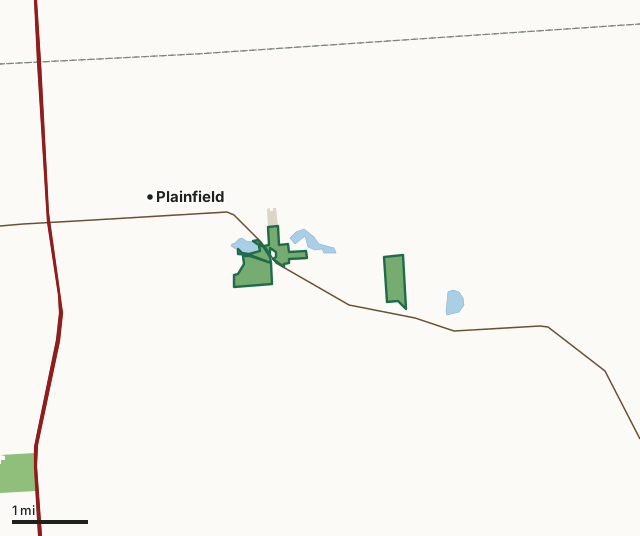
State wildlife areas, forests and other DNR landOther county, city and regional landPlainfield Tunnel Channel Lakes State Natural AreaCounty lineLakeHighway
| Size | 288 acres in 5 pieces |
|---|---|
| County | Waushara County |
| Deer Management Unit | Waushara County |
| Public access (DNR) | Open to Hiking, Fishing, Hunting and Trapping |
| DNR property page | Plainfield Tunnel Channel Lakes |
| Nearest towns | Plainfield (next to it), Almond (4 mi) and Hancock (5 mi) |
What is Plainfield Tunnel Channel Lakes State Natural Area like?
The Plainfield Tunnel Channel Lakes provide specialized habitat for one of the rare members of the bean family which grows here and nowhere else. It is adapted to the sandy shores of shallow seepage lakes whose shorelines fluctuate widely over months or years depending on rainfall and drought patterns. When the shore is exposed, seeds in the seed bank germinate, grow, flower, and drop seeds. The plant requires open, sunny habitat and relies on periodic flooding to kill shade-producing trees that invade the shoreline in dry years. The plant survives inundation - up to years at a time - by persisting in the lake bottom's seed bank until the water levels drop. Protected are the shorelines of three lakes in a string of 13 lakes and ponds lying in a "tunnel channel" created by a meltwater river flowing beneath the glacial ice.
From the intersection of State Highway 73 and County Highway BB on the east side of Plainfield, go east and south on 73 0.85 miles to a parking area west of the road. Plainfield Tunnel Channel Lakes is owned by: Wisconsin DNR.
In the DNR's words, from its page for the property.
What are the rules on Plainfield Tunnel Channel Lakes State Natural Area?
The DNR's property map lists Plainfield Tunnel Channel Lakes State Natural Area as "Open to Hiking, Fishing, Hunting and Trapping". Hunting follows Wisconsin's statewide seasons and the rules posted on the property.
How many deer are taken around Plainfield Tunnel Channel Lakes State Natural Area?
Plainfield Tunnel Channel Lakes State Natural Area lies in Waushara County. The DNR registered 8,678 deer in Waushara County in 2025, against 8,191 in 2024.
| DMU | Plainfield Tunnel Channel Lakes State Natural Area acres in it | Deer, 2025 | Deer, 2024 | Deer, 2023 |
|---|---|---|---|---|
| Waushara County | 288 | 8,678 | 8,191 | 6,404 |
Harvest for the whole deer management unit, not the property alone: Wisconsin DNR Deer Metrics (registered harvest by deer management unit).
How do you get to Plainfield Tunnel Channel Lakes State Natural Area?
Nearest towns: Plainfield (next to it), Almond (4 miles), Hancock (5 miles) and Bancroft (7 miles). Highways within 5 miles: US 51, I-39 and WI 73.
What other public land is near Plainfield Tunnel Channel Lakes State Natural Area?
DNR properties within 10 miles:
- Big Roche A Cri Fishery Area: 845 acres, 3.4 miles away
- State Ice Age Trail Area (SIATA): 4,676 acres, 4.7 miles away
- Ten Mile Creek-North Branch SHA: 101 acres, 5.8 miles away
- Greenwood Wildlife Area: 1,442 acres, 6 miles away
- Buena Vista Wildlife Area: 12,552 acres, 6.6 miles away
- Leola Marsh Wildlife Area: 2,518 acres, 7.3 miles away
Public land within 3 miles of Plainfield Tunnel Channel Lakes State Natural Area
Counting Plainfield Tunnel Channel Lakes State Natural Area itself, 313 of the 30,181 acres within 3 miles of its boundary are public land open to the public (1%), by USGS PAD-US 4.1 (fee land open to the public).
| Manager | Acres within 3 miles |
|---|---|
| State wildlife areas, forests and other DNR land | 295 |
| Other county, city and regional land | 18 |
Questions hunters ask
Where is Plainfield Tunnel Channel Lakes State Natural Area?
In Waushara County, next to Plainfield. The DNR's property page has its maps and parking.
Is Plainfield Tunnel Channel Lakes State Natural Area open to hunting?
Yes. The DNR's property map lists it as "Open to Hiking, Fishing, Hunting and Trapping". Posted refuges or closed areas, where there are any, are marked on site.
Which deer management unit is Plainfield Tunnel Channel Lakes State Natural Area in?
Waushara County.
How much public land is around Plainfield Tunnel Channel Lakes State Natural Area?
313 acres within 3 miles of its boundary, Plainfield Tunnel Channel Lakes State Natural Area included, by PAD-US 4.1. The closest other DNR property is Big Roche A Cri Fishery Area (3.4 miles).
Get a Wisconsin hunt plan when they open
Hunt plans for Wisconsin are coming. Join the list and you'll hear first. The first 50 hunters in each new state get their plan free.
Until then, the free FilledTag app for iPhone has a map that works in every state, Wisconsin included.
Where these facts come from
- Area description, species, rules and directions: DNR, Plainfield Tunnel Channel Lakes State Natural Area; Wisconsin DNR managed lands open to hunting.
- Boundary and acres: the DNR's map layer above. Surrounding public land: USGS PAD-US 4.1 (fee land open to the public).
- Deer harvest: Wisconsin DNR Deer Metrics (registered harvest by deer management unit).
FilledTag is not part of the Wisconsin Department of Natural Resources. Check the DNR's rules and posted signs before you go.