Prince's Point Wildlife Area: hunting and access
Prince's Point Wildlife Area is 3,979 acres of land managed by the Wisconsin DNR in Jefferson County, next to Hebron. The DNR's page for it names deer, wild turkey, pheasants, ducks and geese and small game among the game here. Hunters registered 3,843 deer in Jefferson County in 2025.
Data updated October 2026. Area facts: the DNR's DNR property data, read 2026-10. Harvest: DNR Deer Metrics.
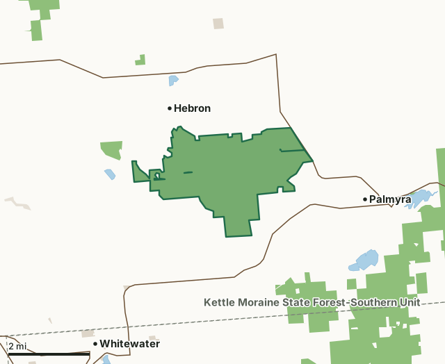
State wildlife areas, forests and other DNR landOther county, city and regional landLand trusts and other open landPrince's Point Wildlife AreaCounty lineLakeHighway
| Size | 3,979 acres |
|---|---|
| County | Jefferson County |
| Deer Management Unit | Jefferson County |
| DNR lists for hunting | deer, wild turkey, pheasants, ducks and geese and small game |
| Public access (DNR) | Open to Hiking, Fishing, Hunting and Trapping |
| DNR property page | Princes Point Wildlife Area |
| Nearest towns | Hebron (next to it), Palmyra (2 mi) and Whitewater (4 mi) |
What is Prince's Point Wildlife Area like?
Princes Point Wildlife Area was recently expanded to nearly double its size. Approximately 1,830 acres were added to the property's southern edge, but this new area is closed to the public for construction. Check the map (below) to see which area is closed to the public. Several wetland restoration projects are scheduled to begin in late 2023 and will likely continue until 2025 or later, depending on construction times. These restoration projects will restore hydrology on the property and feature four impoundments. Additional infrastructure, signage and parking lots will also be added when this new section is closer to opening up to the public.
The DNR is excited about this acquisition and the additional opportunities it provides to nearly four million Wisconsinites who live within an hour of Princes Point Wildlife Area. Construction updates will be shared on this page as they are available. Princes Point Wildlife Area consists of approximately 3,700 acres of primarily riparian wetlands associated with the confluence of Spring Creek, the Scuppernong River and the Bark River. The property is known for waterfowl hunting opportunities, with two existing impoundments and four additional impoundments being added and restored in 2024-2025. The Scuppernong River bisects the wildlife area and provides an easy paddle between boat launches on the east and west sides of the property.
In the DNR's words, from its page for the property.
What can you hunt on Prince's Point Wildlife Area?
The DNR's page for Prince's Point Wildlife Area names deer, wild turkey, pheasants, ducks and geese and small game. Each follows Wisconsin's statewide season and, for deer, the tags and rules of the deer management unit.
What are the rules on Prince's Point Wildlife Area?
The DNR's property map lists Prince's Point Wildlife Area as "Open to Hiking, Fishing, Hunting and Trapping". Hunting follows Wisconsin's statewide seasons and the rules posted on the property.
Activities the DNR lists for Prince's Point Wildlife Area: Birding, Boating (motorized), Canoeing, Kayaking, Cross-country skiing (no designated trail), Fishing, Hiking, Hunting (especially noted for waterfowl, pheasant, deer, turkey and small game*), Trapping, Wild edibles/gathering ( What can I collect? ) and Wildlife viewing.
How many deer are taken around Prince's Point Wildlife Area?
Prince's Point Wildlife Area lies in Jefferson County. The DNR registered 3,843 deer in Jefferson County in 2025, against 3,816 in 2024.
| DMU | Prince's Point Wildlife Area acres in it | Deer, 2025 | Deer, 2024 | Deer, 2023 |
|---|---|---|---|---|
| Jefferson County | 3,979 | 3,843 | 3,816 | 3,579 |
Harvest for the whole deer management unit, not the property alone: Wisconsin DNR Deer Metrics (registered harvest by deer management unit).
How do you get to Prince's Point Wildlife Area?
Nearest towns: Hebron (next to it), Palmyra (2 miles), Whitewater (4 miles) and Rome (5 miles). Highways within 5 miles: WI 59, WI 106, US 12 and WI 89.
What other public land is near Prince's Point Wildlife Area?
DNR properties within 10 miles:
- Kettle Moraine State Forest-Southern Unit: 21,556 acres, 1.4 miles away
- Rome Pond Wildlife Area: 2,295 acres, 3.4 miles away
- Jefferson Marsh State Wildlife And Natural Area: 3,326 acres, 3.7 miles away
- Paradise Valley Wildlife Area: 1,788 acres, 4.8 miles away
- Lima Marsh - Storrs Lake Wildlife Area: 2,988 acres, 6 miles away
Public land within 3 miles of Prince's Point Wildlife Area
Counting Prince's Point Wildlife Area itself, 5,355 of the 44,884 acres within 3 miles of its boundary are public land open to the public (11.9%), by USGS PAD-US 4.1 (fee land open to the public).
| Manager | Acres within 3 miles |
|---|---|
| State wildlife areas, forests and other DNR land | 5,284 |
| Other county, city and regional land | 47 |
| Land trusts and other open land | 24 |
Questions hunters ask
Where is Prince's Point Wildlife Area?
In Jefferson County, next to Hebron. The DNR's property page has its maps and parking.
Is Prince's Point Wildlife Area open to hunting?
Yes. The DNR's property map lists it as "Open to Hiking, Fishing, Hunting and Trapping". Posted refuges or closed areas, where there are any, are marked on site.
Which deer management unit is Prince's Point Wildlife Area in?
Jefferson County.
How much public land is around Prince's Point Wildlife Area?
5,355 acres within 3 miles of its boundary, Prince's Point Wildlife Area included, by PAD-US 4.1. The closest other DNR property is Kettle Moraine State Forest-Southern Unit (1.4 miles).
Get a Wisconsin hunt plan when they open
Hunt plans for Wisconsin are coming. Join the list and you'll hear first. The first 50 hunters in each new state get their plan free.
Until then, the free FilledTag app for iPhone has a map that works in every state, Wisconsin included.
Where these facts come from
- Area description, species, rules and directions: DNR, Prince's Point Wildlife Area; Wisconsin DNR managed lands open to hunting.
- Boundary and acres: the DNR's map layer above. Surrounding public land: USGS PAD-US 4.1 (fee land open to the public).
- Deer harvest: Wisconsin DNR Deer Metrics (registered harvest by deer management unit).
FilledTag is not part of the Wisconsin Department of Natural Resources. Check the DNR's rules and posted signs before you go.