Quincy Bluff and Wetlands State Natural Area: hunting and access
Quincy Bluff and Wetlands State Natural Area is 6,591 acres of land managed by the Wisconsin DNR in Adams County, 2 miles from Dellwood. Hunters registered 6,148 deer in Adams County in 2025.
Data updated October 2026. Area facts: the DNR's DNR property data, read 2026-10. Harvest: DNR Deer Metrics.
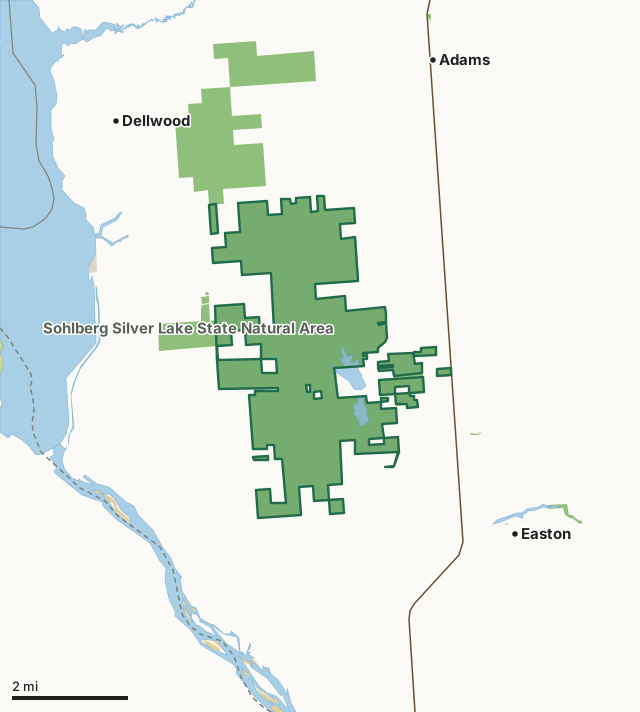
State wildlife areas, forests and other DNR landCounty forestOther federal landOther county, city and regional landQuincy Bluff and Wetlands State Natural AreaCounty lineLakeHighway
| Size | 6,591 acres in 9 pieces |
|---|---|
| County | Adams County |
| Deer Management Unit | Adams County |
| Public access (DNR) | Open to Hiking, Fishing, Hunting and Trapping |
| DNR property page | Quincy Bluff And Wetlands |
| Nearest towns | Dellwood (2 mi), Easton (2 mi) and Adams (3 mi) |
What is Quincy Bluff and Wetlands State Natural Area like?
Quincy Bluff and Wetlands is a large, landscape-scale natural area featuring a mosaic of communities including northern wet and wet-mesic forest, northern and southern sedge meadow, shrub-carr, pine barrens, and sand prairie. This unique area is located in the Central Sand Plain ecoregion of Wisconsin, the bed of extinct Glacial Lake Wisconsin and features a vast wetland complex with low sandy ridges, wetlands, and seepage ponds situated between sandstone mesas and buttes that rise 100-200 feet. Quincy Bluff, which rises 200 feet high and extends for approximately two miles, contains northern dry forest and open cliff communities. Lone Rock, an excellent example of a Driftless Area mesa, features one hundred-foot Cambrian sandstone cliffs. The uplands are forested with jack pine and Hill's oak with a shrub layer dominated by huckleberry, American hazelnut and early low blueberry.
In 2013, the Nature Conservancy donated its remaining 1,700 acres at Quincy Bluff to the state. In addition, the Conservancy also donated a permanent endowment to supplement management costs at the preserve, with the funds to be managed by a qualified foundation. This gift of land will better enable the DNR to streamline management across the natural area, particularly the use of prescribed fire to restore rare oak barrens. Adams County. T16N-R5E, Sections 1-4, 10-15, 22, 23, 24, 26, 27. T16N-R6E, Sections 7, 18. T17N-R5E, Sections 25, 26, 27, 34, 35, 36. 6,603 acres. From the intersection of Highways 13 and H just east of White Creek, go west on H for 2.6 miles, then north on 16th Avenue for 0.4 miles, then west on Evergreen Avenue for 0.5 miles, then north on 16th Drive for 2.4 miles to a parking area east of the road.
In the DNR's words, from its page for the property.
What are the rules on Quincy Bluff and Wetlands State Natural Area?
The DNR's property map lists Quincy Bluff and Wetlands State Natural Area as "Open to Hiking, Fishing, Hunting and Trapping". Hunting follows Wisconsin's statewide seasons and the rules posted on the property.
How many deer are taken around Quincy Bluff and Wetlands State Natural Area?
Quincy Bluff and Wetlands State Natural Area lies in Adams County. The DNR registered 6,148 deer in Adams County in 2025, against 6,658 in 2024.
| DMU | Quincy Bluff and Wetlands State Natural Area acres in it | Deer, 2025 | Deer, 2024 | Deer, 2023 |
|---|---|---|---|---|
| Adams County | 6,591 | 6,148 | 6,658 | 5,428 |
Harvest for the whole deer management unit, not the property alone: Wisconsin DNR Deer Metrics (registered harvest by deer management unit).
How do you get to Quincy Bluff and Wetlands State Natural Area?
Nearest towns: Dellwood (2 miles), Easton (2 miles), Adams (3 miles) and Friendship (4 miles). Highways within 5 miles: WI 13 and WI 82.
What other public land is near Quincy Bluff and Wetlands State Natural Area?
DNR properties within 10 miles:
- Sohlberg Silver Lake State Natural Area: 315 acres, next to it
- Central Sands Pines Forest Legacy Easement: 9,122 acres, next to it
- Campbell Creek-White Creek SHA: 26 acres, 2.7 miles away
- Buckhorn Wildlife Area: 1,677 acres, 3.9 miles away
- Buckhorn State Park: 4,000 acres, 4 miles away
Public land within 3 miles of Quincy Bluff and Wetlands State Natural Area
Counting Quincy Bluff and Wetlands State Natural Area itself, 9,124 of the 59,025 acres within 3 miles of its boundary are public land open to the public (15.5%), by USGS PAD-US 4.1 (fee land open to the public).
| Manager | Acres within 3 miles |
|---|---|
| State wildlife areas, forests and other DNR land | 8,949 |
| Other federal land | 150 |
| Other county, city and regional land | 24 |
| Land trusts and other open land | 1 |
Questions hunters ask
Where is Quincy Bluff and Wetlands State Natural Area?
In Adams County, 2 miles from Dellwood. The DNR's property page has its maps and parking.
Is Quincy Bluff and Wetlands State Natural Area open to hunting?
Yes. The DNR's property map lists it as "Open to Hiking, Fishing, Hunting and Trapping". Posted refuges or closed areas, where there are any, are marked on site.
Which deer management unit is Quincy Bluff and Wetlands State Natural Area in?
Adams County.
How much public land is around Quincy Bluff and Wetlands State Natural Area?
9,124 acres within 3 miles of its boundary, Quincy Bluff and Wetlands State Natural Area included, by PAD-US 4.1. The closest other DNR property is Sohlberg Silver Lake State Natural Area (next to it).
Get a Wisconsin hunt plan when they open
Hunt plans for Wisconsin are coming. Join the list and you'll hear first. The first 50 hunters in each new state get their plan free.
Until then, the free FilledTag app for iPhone has a map that works in every state, Wisconsin included.
Where these facts come from
- Area description, species, rules and directions: DNR, Quincy Bluff and Wetlands State Natural Area; Wisconsin DNR managed lands open to hunting.
- Boundary and acres: the DNR's map layer above. Surrounding public land: USGS PAD-US 4.1 (fee land open to the public).
- Deer harvest: Wisconsin DNR Deer Metrics (registered harvest by deer management unit).
FilledTag is not part of the Wisconsin Department of Natural Resources. Check the DNR's rules and posted signs before you go.