Rice Beds Creek Wildlife Area: hunting and access
Rice Beds Creek Wildlife Area is 3,137 acres of land managed by the Wisconsin DNR in Polk County, 7 miles from Turtle Lake. The DNR's page for it names deer, wild turkey, ducks and geese and bear among the game here. Hunters registered 8,091 deer in Polk County in 2025.
Data updated October 2026. Area facts: the DNR's DNR property data, read 2026-10. Harvest: DNR Deer Metrics.
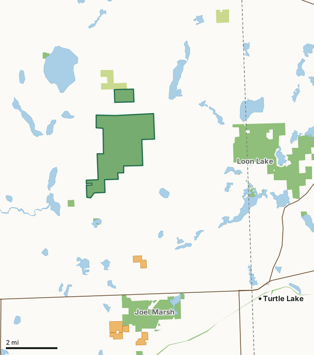
State wildlife areas, forests and other DNR landCounty forestOther county, city and regional landVoluntary Public Access landRice Beds Creek Wildlife AreaCounty lineLakeHighway
| Size | 3,137 acres in 2 pieces |
|---|---|
| County | Polk County |
| Deer Management Unit | Polk County |
| DNR lists for hunting | deer, wild turkey, ducks and geese and bear |
| Public access (DNR) | Open to Hiking, Fishing, Hunting and Trapping |
| DNR property page | Rice Beds Creek Wildlife Area |
| Nearest towns | Turtle Lake (7 mi), Balsam Lake (8 mi) and Clayton (10 mi) |
What is Rice Beds Creek Wildlife Area like?
Rice Beds Creek Wildlife Area is a 3,181-acre property in Polk County. It consists of rolling oak, aspen, and maple upland forest, lowland forest, streams and ponds. Find it 6 miles northwest of Turtle Lake. Head north on Highway T for 7 miles to Highway G, then travel west for 2 miles. There are five parking areas along Highway G on the south side of the road. To reach the wildlife area from Range, travel north on Highway D for 4 miles to Highway V. The property can be accessed by traveling 1/2 mile east on Highway V to a parking lot on the north side of the road or by continuing to the parking area on Highway D.
Rice Beds Creek runs through this property and allows visitors to fish and trap, along with this, the surrounding forests offer great deer and turkey hunting. There was a blow-down event in 2019. Salvage logging was done on much of the property making it easier to access and allowing for the forest to regenerate more quickly. Note: No bikes or e-bikes are allowed on the property. Rice Beds Creek Wildlife Area was established in 1951 to acquire and protect deer wintering habitat. Later, the project was expanded for multiple use benefits such as upland game, waterfowl and furbearers. The area is popular with deer and grouse hunters because of the favorable habitat created by forest management. A well-maintained trail system is accessible from the main parking lot on Highway G. Access is by foot traffic only. The Rice Beds Creek Wildlife Area offers many recreational opportunities:.
In the DNR's words, from its page for the property.
What can you hunt on Rice Beds Creek Wildlife Area?
The DNR's page for Rice Beds Creek Wildlife Area names deer, wild turkey, ducks and geese and bear. Each follows Wisconsin's statewide season and, for deer, the tags and rules of the deer management unit.
What are the rules on Rice Beds Creek Wildlife Area?
The DNR's property map lists Rice Beds Creek Wildlife Area as "Open to Hiking, Fishing, Hunting and Trapping". Hunting follows Wisconsin's statewide seasons and the rules posted on the property.
Activities the DNR lists for Rice Beds Creek Wildlife Area: Birding, Canoeing, Cross-country skiing (no designated trail), Fishing, Hiking (no designated trail), Hunting (noted for deer, bear, turkey and waterfowl), Kayaking, Trapping, Wild edibles/gathering and Wildlife viewing.
How many deer are taken around Rice Beds Creek Wildlife Area?
Rice Beds Creek Wildlife Area lies in Polk County. The DNR registered 8,091 deer in Polk County in 2025, against 7,972 in 2024.
| DMU | Rice Beds Creek Wildlife Area acres in it | Deer, 2025 | Deer, 2024 | Deer, 2023 |
|---|---|---|---|---|
| Polk County | 3,137 | 8,091 | 7,972 | 7,275 |
Harvest for the whole deer management unit, not the property alone: Wisconsin DNR Deer Metrics (registered harvest by deer management unit).
How do you get to Rice Beds Creek Wildlife Area?
Nearest towns: Turtle Lake (7 miles), Balsam Lake (8 miles), Clayton (10 miles) and Cumberland (10 miles). Highways within 5 miles: US 8, WI 46 and WI 48. 1 VPA property within 3 miles.
What other public land is near Rice Beds Creek Wildlife Area?
DNR properties within 10 miles:
- Loon Lake Wildlife Area: 3,222 acres, 3 miles away
- Joel Marsh Wildlife Area: 1,367 acres, 4 miles away
- State Ice Age Trail Area (SIATA): 4,676 acres, 5.3 miles away
Public land within 3 miles of Rice Beds Creek Wildlife Area
Counting Rice Beds Creek Wildlife Area itself, 3,528 of the 43,939 acres within 3 miles of its boundary are public land open to the public (8%), by USGS PAD-US 4.1 (fee land open to the public).
| Manager | Acres within 3 miles |
|---|---|
| State wildlife areas, forests and other DNR land | 3,248 |
| County forest | 280 |
Questions hunters ask
Where is Rice Beds Creek Wildlife Area?
In Polk County, 7 miles from Turtle Lake. The DNR's property page has its maps and parking.
Is Rice Beds Creek Wildlife Area open to hunting?
Yes. The DNR's property map lists it as "Open to Hiking, Fishing, Hunting and Trapping". Posted refuges or closed areas, where there are any, are marked on site.
Which deer management unit is Rice Beds Creek Wildlife Area in?
Polk County.
How much public land is around Rice Beds Creek Wildlife Area?
3,528 acres within 3 miles of its boundary, Rice Beds Creek Wildlife Area included, by PAD-US 4.1. The closest other DNR property is Loon Lake Wildlife Area (3 miles).
Get a Wisconsin hunt plan when they open
Hunt plans for Wisconsin are coming. Join the list and you'll hear first. The first 50 hunters in each new state get their plan free.
Until then, the free FilledTag app for iPhone has a map that works in every state, Wisconsin included.
Where these facts come from
- Area description, species, rules and directions: DNR, Rice Beds Creek Wildlife Area; Wisconsin DNR managed lands open to hunting.
- Boundary and acres: the DNR's map layer above. Surrounding public land: USGS PAD-US 4.1 (fee land open to the public).
- Deer harvest: Wisconsin DNR Deer Metrics (registered harvest by deer management unit).
FilledTag is not part of the Wisconsin Department of Natural Resources. Check the DNR's rules and posted signs before you go.