Snow Bottom State Natural Area: hunting and access
Snow Bottom State Natural Area is 350 acres of land managed by the Wisconsin DNR in Grant County, 5 miles from Highland. Hunters registered 5,741 deer in Grant County in 2025.
Data updated October 2026. Area facts: the DNR's DNR property data, read 2026-10. Harvest: DNR Deer Metrics.
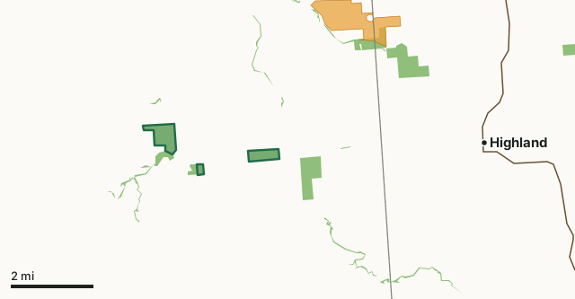
State wildlife areas, forests and other DNR landVoluntary Public Access landSnow Bottom State Natural AreaCounty lineHighway
| Size | 350 acres in 3 pieces |
|---|---|
| County | Grant County |
| Deer Management Unit | Grant County |
| Public access (DNR) | Open to Hiking, Fishing, Hunting and Trapping |
| DNR property page | Snow Bottom |
| Nearest towns | Highland (5 mi), Montfort (6 mi) and Fennimore (8 mi) |
What is Snow Bottom State Natural Area like?
Snow Bottom State Natural Area lies in the very heart of a diverse and spectacular Driftless Area landscape. It encompasses the most significant pine relicts in Wisconsin, as well as many other important and uncommon native plant communities including fen and springs, southern dry-mesic forest and oak woodland, riparian areas, and geological features. Located on the scattered sandstone outcrops are the pine relicts -- isolated stands of white and red pine with occasional jack pine. Understory plant species include numerous evergreen and ericaceous species such as blueberry, huckleberry, pipsissewa, and partridgeberry. Red oak dominates the dry-mesic forest with white oak, sugar maple, basswood, and red maple and the herbaceous understory is diverse with jack-in-the-pulpit, enchanter's nightshade, large-flowered bellwort, interrupted fern, lady fern, tick-trefoils, and hog peanut.
Grant County. T7N-R1W, Sections 27, 28, 30, 34, 35. 676 acres. From the intersection of State Highway 18 and County G west of Montfort, go north on G for 4.6 miles, then east on Bowers Road for 1.6 miles to a small parking area just west of the Blue River. Walk north into the site. To access the western SNA parcel, from the intersection of County Q and G (located east of Castle Rock), go west on County Q for 1.6 miles, then north and west on Cedar Rock Road for about 0.4 miles. Walk north into the SNA. A paddle through Snow Bottom on the Blue River is rewarding, but possible only with small kayaks during periods of adequate river flow, usually in spring. The twisty, 5.5-mile section of river from the Bowers Road parking lot downstream to Shemak Road is wild, offering wonderful Driftless Area scenery and excellent trout fishing. Snow Bottom is owned by: Private and the Wisconsin DNR.
In the DNR's words, from its page for the property.
What are the rules on Snow Bottom State Natural Area?
The DNR's property map lists Snow Bottom State Natural Area as "Open to Hiking, Fishing, Hunting and Trapping". Hunting follows Wisconsin's statewide seasons and the rules posted on the property.
How many deer are taken around Snow Bottom State Natural Area?
Snow Bottom State Natural Area lies in Grant County. The DNR registered 5,741 deer in Grant County in 2025, against 6,014 in 2024.
| DMU | Snow Bottom State Natural Area acres in it | Deer, 2025 | Deer, 2024 | Deer, 2023 |
|---|---|---|---|---|
| Grant County | 350 | 5,741 | 6,014 | 6,464 |
Harvest for the whole deer management unit, not the property alone: Wisconsin DNR Deer Metrics (registered harvest by deer management unit).
How do you get to Snow Bottom State Natural Area?
Nearest towns: Highland (5 miles), Montfort (6 miles), Fennimore (8 miles) and Blue River (9 miles). Highways within 5 miles: US 18.
What other public land is near Snow Bottom State Natural Area?
Public land within 3 miles of Snow Bottom State Natural Area
Counting Snow Bottom State Natural Area itself, 827 of the 33,566 acres within 3 miles of its boundary are public land open to the public (2.5%), by USGS PAD-US 4.1 (fee land open to the public).
| Manager | Acres within 3 miles |
|---|---|
| State wildlife areas, forests and other DNR land | 827 |
Questions hunters ask
Where is Snow Bottom State Natural Area?
In Grant County, 5 miles from Highland. The DNR's property page has its maps and parking.
Is Snow Bottom State Natural Area open to hunting?
Yes. The DNR's property map lists it as "Open to Hiking, Fishing, Hunting and Trapping". Posted refuges or closed areas, where there are any, are marked on site.
Which deer management unit is Snow Bottom State Natural Area in?
Grant County.
How much public land is around Snow Bottom State Natural Area?
827 acres within 3 miles of its boundary, Snow Bottom State Natural Area included, by PAD-US 4.1.
Get a Wisconsin hunt plan when they open
Hunt plans for Wisconsin are coming. Join the list and you'll hear first. The first 50 hunters in each new state get their plan free.
Until then, the free FilledTag app for iPhone has a map that works in every state, Wisconsin included.
Where these facts come from
- Area description, species, rules and directions: DNR, Snow Bottom State Natural Area; Wisconsin DNR managed lands open to hunting.
- Boundary and acres: the DNR's map layer above. Surrounding public land: USGS PAD-US 4.1 (fee land open to the public).
- Deer harvest: Wisconsin DNR Deer Metrics (registered harvest by deer management unit).
FilledTag is not part of the Wisconsin Department of Natural Resources. Check the DNR's rules and posted signs before you go.