Spread Eagle Barrens State Natural Area: hunting and access
Spread Eagle Barrens State Natural Area is 7,889 acres of land managed by the Wisconsin DNR in Florence County, 4 miles from Florence. Hunters registered 2,310 deer in DMU 125 in 2025.
Data updated October 2026. Area facts: the DNR's DNR property data, read 2026-10. Harvest: DNR Deer Metrics.
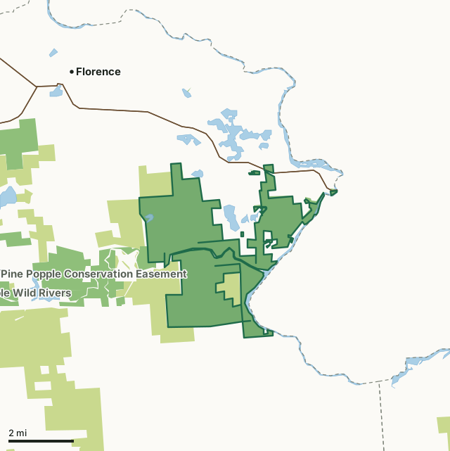
State wildlife areas, forests and other DNR landCounty forestSpread Eagle Barrens State Natural AreaCounty lineLakeHighway
| Size | 7,889 acres in 13 pieces |
|---|---|
| County | Florence County |
| Deer Management Unit | DMU 125 |
| Public access (DNR) | Open to Hiking, Fishing, Hunting and Trapping |
| DNR property page | Spread Eagle Barrens |
| Nearest towns | Florence (4 mi), Niagara (6 mi) and Dunbar (11 mi) |
What is Spread Eagle Barrens State Natural Area like?
Spread Eagle Barrens protects an extensive landscape of bracken grassland and barrens dominated by scattered jack pine, red pine, scrub oak and quaking aspen. The sandy soils support an understory of sedges, bracken and sweet fern, slender wheatgrass, muhly grass, poverty oats, hazelnut, serviceberry, blueberry and willows. A mosaic of six different communities, the natural area was established to protect the Pine Barrens community and associated flora and fauna that require large expanses of open vegetation. Frost pockets, and treeless depressions where frost may occur at any time of year, punctuate the landscape. Sedges, lichens and other plant species have adapted to this harsh microclimate and can dominate these low-lying areas. In contrast, bracken fern, Jack pines and other small trees dominate the uplands where they are interspersed with grasses.
Four parking areas: 1) From the intersection of U.S. 2 and Old Highway 69 Road in Spread Eagle, go south and west of Old 69 Road for 0.5 miles, then south on W. Ellwood Lake Road about 1.2 miles to a parking area. 2) From the intersection of U.S. 2 and Old Highway 69, go south and west on Old 69 for 0.85 miles, then south on Lake Anna Road for 0.8 miles, then south on Overlook Road for 1 mile to the parking area. 3) From the intersection of U.S. 2 and East Ellwood Lake Road in Spread Eagle, go south on East Ellwood Lake Road 2.5 miles, then southeast on Menominee River Road 1.3 miles to a parking area north of the road. 4) From the intersection of U.S. 2 and County N in Florence, go south on County N for 8 miles, then east on Roach Fire Lane Road for about 2.9 miles to a parking area on the left. Spread Eagle Barrens is owned by the Wisconsin DNR and WE Energies.
In the DNR's words, from its page for the property.
What are the rules on Spread Eagle Barrens State Natural Area?
The DNR's property map lists Spread Eagle Barrens State Natural Area as "Open to Hiking, Fishing, Hunting and Trapping". Hunting follows Wisconsin's statewide seasons and the rules posted on the property.
How many deer are taken around Spread Eagle Barrens State Natural Area?
Spread Eagle Barrens State Natural Area lies in DMU 125. The DNR registered 2,310 deer in DMU 125 in 2025.
| DMU | Spread Eagle Barrens State Natural Area acres in it | Deer, 2025 |
|---|---|---|
| DMU 125 | 7,889 | 2,310 |
Harvest for the whole deer management unit, not the property alone: Wisconsin DNR Deer Metrics (registered harvest by deer management unit).
How do you get to Spread Eagle Barrens State Natural Area?
Nearest towns: Florence (4 miles), Niagara (6 miles), Dunbar (11 miles) and Pembine (13 miles). Highways within 5 miles: US 2, US 141, WI 101 and WI 70.
What other public land is near Spread Eagle Barrens State Natural Area?
DNR properties within 10 miles:
- Pine-Popple Wild Rivers: 11,648 acres, next to it
- Wild Rivers/Pine Popple Conservation Easement: 58,880 acres, 1.7 miles away
Public land within 3 miles of Spread Eagle Barrens State Natural Area
Counting Spread Eagle Barrens State Natural Area itself, 13,536 of the 68,108 acres within 3 miles of its boundary are public land open to the public (19.9%), by USGS PAD-US 4.1 (fee land open to the public).
| Manager | Acres within 3 miles |
|---|---|
| State wildlife areas, forests and other DNR land | 10,016 |
| County forest | 3,515 |
| State parks | 5 |
Questions hunters ask
Where is Spread Eagle Barrens State Natural Area?
In Florence County, 4 miles from Florence. The DNR's property page has its maps and parking.
Is Spread Eagle Barrens State Natural Area open to hunting?
Yes. The DNR's property map lists it as "Open to Hiking, Fishing, Hunting and Trapping". Posted refuges or closed areas, where there are any, are marked on site.
Which deer management unit is Spread Eagle Barrens State Natural Area in?
DMU 125.
How much public land is around Spread Eagle Barrens State Natural Area?
13,536 acres within 3 miles of its boundary, Spread Eagle Barrens State Natural Area included, by PAD-US 4.1. The closest other DNR property is Pine-Popple Wild Rivers (next to it).
Get a Wisconsin hunt plan when they open
Hunt plans for Wisconsin are coming. Join the list and you'll hear first. The first 50 hunters in each new state get their plan free.
Until then, the free FilledTag app for iPhone has a map that works in every state, Wisconsin included.
Where these facts come from
- Area description, species, rules and directions: DNR, Spread Eagle Barrens State Natural Area; Wisconsin DNR managed lands open to hunting.
- Boundary and acres: the DNR's map layer above. Surrounding public land: USGS PAD-US 4.1 (fee land open to the public).
- Deer harvest: Wisconsin DNR Deer Metrics (registered harvest by deer management unit).
FilledTag is not part of the Wisconsin Department of Natural Resources. Check the DNR's rules and posted signs before you go.