Spring Creek Wildlife Area: hunting and access
Spring Creek Wildlife Area is 919 acres of land managed by the Wisconsin DNR in Price County, 4 miles from Catawba. The DNR's page for it names deer, ducks and geese and ruffed grouse among the game here. Hunters registered 3,013 deer in DMU 115 in 2025.
Data updated October 2026. Area facts: the DNR's DNR property data, read 2026-10. Harvest: DNR Deer Metrics.
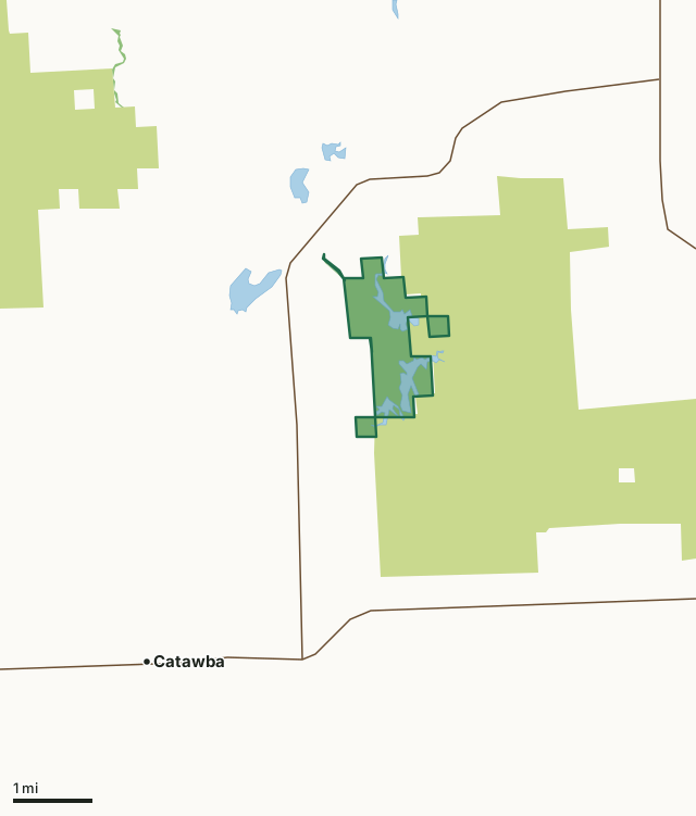
State wildlife areas, forests and other DNR landCounty forestSpring Creek Wildlife AreaCounty lineLakeHighway
| Size | 919 acres in 5 pieces |
|---|---|
| County | Price County |
| Deer Management Unit | DMU 115 |
| DNR lists for hunting | deer, ducks and geese and ruffed grouse |
| Public access (DNR) | Open to Hiking, Fishing, Hunting and Trapping |
| DNR property page | Spring Creek Wildlife Area |
| Nearest towns | Catawba (4 mi), Kennan (6 mi) and Phillips (7 mi) |
What is Spring Creek Wildlife Area like?
Spring Creek Wildlife Area is a 1,000-acre property located eight miles southwest of Phillips in Price County. The diverse wildlife area includes four waterfowl flowages totaling 220 acres of water at full capacity as well as 261 acres of aspen, 156 acres of upland brush, 200 acres of lowland brush, 150 acres of conifer and muskeg and 16 acres of fallow field/grassland. The staple of Spring Creek are its four managed flowages at the confluence of three waterways. These flowages have been a long-standing wild rice resource for foragers and wildlife alike. The wetlands and wild rice support waterfowl, furbearers and many non-game birds like eagles, ospreys and swans. Several hundred swans and thousands of ducks have been observed on Spring Creek during spring migration.
The surrounding landscape is mostly forested with dotted grasslands and wetlands. Aspen is the dominant type of forest and is managed for excellent ruffed grouse habitat. Among the grouse, many deer, turkey and bear can be seen or pursued on the property. To get to Spring Creek Wildlife Area, travel 5 miles southwest on State Highway 111, just south of Phillips, from State Highway 13. Then travel 1/3 of a mile south on Pioneer Road to reach Spring Creek Way, which will take you to the property entrance. The Spring Creek property was initiated in 1962 with the purchase of 923 acres from the Hladish family. Two existing flowages were upgraded, and two additional flowages have been constructed for wildlife habitat and public use. Over three miles of road and two miles of non-motorized trails were improved or constructed for property management and user access.
In the DNR's words, from its page for the property.
What can you hunt on Spring Creek Wildlife Area?
The DNR's page for Spring Creek Wildlife Area names deer, ducks and geese and ruffed grouse. Each follows Wisconsin's statewide season and, for deer, the tags and rules of the deer management unit.
What are the rules on Spring Creek Wildlife Area?
The DNR's property map lists Spring Creek Wildlife Area as "Open to Hiking, Fishing, Hunting and Trapping". Hunting follows Wisconsin's statewide seasons and the rules posted on the property.
Activities the DNR lists for Spring Creek Wildlife Area: Auto travel, Biking, Birding, Boating ( non-motorized only ), Canoeing, Cross-country skiing (no designated trail), Fishing, Hiking (no designated trail), Hunting (noted for ruffed grouse, deer and waterfowl), Kayaking, Trapping, Snowmobiling trail, Wild edibles/gathering and Wild rice harvesting.
How many deer are taken around Spring Creek Wildlife Area?
Spring Creek Wildlife Area lies in DMU 115. The DNR registered 3,013 deer in DMU 115 in 2025.
| DMU | Spring Creek Wildlife Area acres in it | Deer, 2025 |
|---|---|---|
| DMU 115 | 919 | 3,013 |
Harvest for the whole deer management unit, not the property alone: Wisconsin DNR Deer Metrics (registered harvest by deer management unit).
How do you get to Spring Creek Wildlife Area?
Nearest towns: Catawba (4 miles), Kennan (6 miles), Phillips (7 miles) and Prentice (8 miles). Highways within 5 miles: WI 111, US 8 and WI 13.
What other public land is near Spring Creek Wildlife Area?
DNR properties within 10 miles:
- Carpenter Creek Conservation Easement Area: 48 acres, 3.1 miles away
- Lac Sault Dore State Public Access: 24 acres, 6.8 miles away
Public land within 3 miles of Spring Creek Wildlife Area
Counting Spring Creek Wildlife Area itself, 8,758 of the 31,723 acres within 3 miles of its boundary are public land open to the public (27.6%), by USGS PAD-US 4.1 (fee land open to the public).
| Manager | Acres within 3 miles |
|---|---|
| County forest | 7,828 |
| State wildlife areas, forests and other DNR land | 930 |
Questions hunters ask
Where is Spring Creek Wildlife Area?
In Price County, 4 miles from Catawba. The DNR's property page has its maps and parking.
Is Spring Creek Wildlife Area open to hunting?
Yes. The DNR's property map lists it as "Open to Hiking, Fishing, Hunting and Trapping". Posted refuges or closed areas, where there are any, are marked on site.
Which deer management unit is Spring Creek Wildlife Area in?
DMU 115.
How much public land is around Spring Creek Wildlife Area?
8,758 acres within 3 miles of its boundary, Spring Creek Wildlife Area included, by PAD-US 4.1. The closest other DNR property is Carpenter Creek Conservation Easement Area (3.1 miles).
Get a Wisconsin hunt plan when they open
Hunt plans for Wisconsin are coming. Join the list and you'll hear first. The first 50 hunters in each new state get their plan free.
Until then, the free FilledTag app for iPhone has a map that works in every state, Wisconsin included.
Where these facts come from
- Area description, species, rules and directions: DNR, Spring Creek Wildlife Area; Wisconsin DNR managed lands open to hunting.
- Boundary and acres: the DNR's map layer above. Surrounding public land: USGS PAD-US 4.1 (fee land open to the public).
- Deer harvest: Wisconsin DNR Deer Metrics (registered harvest by deer management unit).
FilledTag is not part of the Wisconsin Department of Natural Resources. Check the DNR's rules and posted signs before you go.