Spruce Grouse Swamp State Natural Area: hunting and access
Spruce Grouse Swamp State Natural Area is 392 acres of land managed by the Wisconsin DNR in Vilas County, 11 miles from Eagle River. Hunters registered 802 deer in DMU 122 in 2025.
Data updated October 2026. Area facts: the DNR's DNR property data, read 2026-10. Harvest: DNR Deer Metrics.
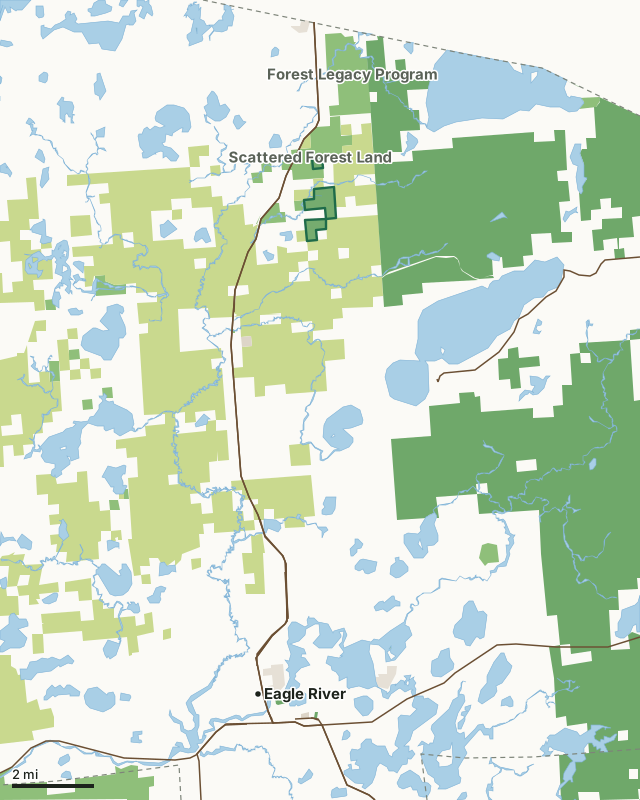
State wildlife areas, forests and other DNR landCounty forestNational forestOther county, city and regional landLand trusts and other open landSpruce Grouse Swamp State Natural AreaCounty lineLakeHighway
| Size | 392 acres in 3 pieces |
|---|---|
| County | Vilas County |
| Deer Management Unit | DMU 122 |
| Public access (DNR) | Open to Hiking, Fishing, Hunting and Trapping |
| DNR property page | Spruce Grouse Swamp |
| Nearest towns | Eagle River (11 mi), Sayner (17 mi) and Three Lakes (19 mi) |
What is Spruce Grouse Swamp State Natural Area like?
Spruce Grouse Swamp is part of an extensive wetland complex southwest of Lac Vieux Desert and features a mosaic of lowland community types including northern sedge meadow, muskeg, black spruce swamp, and tamarack swamp. The surrounding uplands contain a boreal-like dry forest on the low sandy ridges that are found throughout the site. Jackpine with scattered open-grown red pine and black spruce dominate on swamp islands. Aquatic features of interest include Wolf Lake, a small 5-acre bog lake, and a spring-fed cold-water stream. The site provides habitat for several boreal birds including gray jay, boreal chickadee, black-backed woodpecker, Connecticut warbler, and the state-threatened spruce grouse. Of interest are the reported sightings of the federally endangered Kirtland's warbler near this area.
Vilas County. T42N-R10E, Sections 23, 26. 400 acres. From the intersection of County K and Highway 45 in Conover, go east on K for 2.1 miles, then north on Muskrat Creek Road for 2.9 miles, then southwest on Fire Lane Road. Take an immediate right turn on an unmarked road heading west. Follow this road east and north 1.65 miles into the site.
In the DNR's words, from its page for the property.
What are the rules on Spruce Grouse Swamp State Natural Area?
The DNR's property map lists Spruce Grouse Swamp State Natural Area as "Open to Hiking, Fishing, Hunting and Trapping". Hunting follows Wisconsin's statewide seasons and the rules posted on the property.
How many deer are taken around Spruce Grouse Swamp State Natural Area?
Spruce Grouse Swamp State Natural Area lies in DMU 122. The DNR registered 802 deer in DMU 122 in 2025.
| DMU | Spruce Grouse Swamp State Natural Area acres in it | Deer, 2025 |
|---|---|---|
| DMU 122 | 392 | 802 |
Harvest for the whole deer management unit, not the property alone: Wisconsin DNR Deer Metrics (registered harvest by deer management unit).
How do you get to Spruce Grouse Swamp State Natural Area?
Nearest towns: Eagle River (11 miles), Sayner (17 miles), Three Lakes (19 miles) and Boulder Junction (21 miles). Highways within 5 miles: WI 32, US 45 and WI 17.
What other public land is near Spruce Grouse Swamp State Natural Area?
DNR properties within 10 miles:
- Forest Legacy Program: 33,075 acres, next to it
- Tamarack Rearing Station: 170 acres, 4.5 miles away
- Upper Buckatabon Springs State Natural Area: 120 acres, 6.2 miles away
- Lac Vieux Desert State Public Access: 67 acres, 6.3 miles away
Public land within 3 miles of Spruce Grouse Swamp State Natural Area
Counting Spruce Grouse Swamp State Natural Area itself, 16,280 of the 27,920 acres within 3 miles of its boundary are public land open to the public (58.3%), by USGS PAD-US 4.1 (fee land open to the public).
| Manager | Acres within 3 miles |
|---|---|
| County forest | 8,386 |
| National forest | 5,417 |
| State wildlife areas, forests and other DNR land | 2,440 |
| Other county, city and regional land | 37 |
Questions hunters ask
Where is Spruce Grouse Swamp State Natural Area?
In Vilas County, 11 miles from Eagle River. The DNR's property page has its maps and parking.
Is Spruce Grouse Swamp State Natural Area open to hunting?
Yes. The DNR's property map lists it as "Open to Hiking, Fishing, Hunting and Trapping". Posted refuges or closed areas, where there are any, are marked on site.
Which deer management unit is Spruce Grouse Swamp State Natural Area in?
DMU 122.
How much public land is around Spruce Grouse Swamp State Natural Area?
16,280 acres within 3 miles of its boundary, Spruce Grouse Swamp State Natural Area included, by PAD-US 4.1. The closest other DNR property is Forest Legacy Program (next to it).
Get a Wisconsin hunt plan when they open
Hunt plans for Wisconsin are coming. Join the list and you'll hear first. The first 50 hunters in each new state get their plan free.
Until then, the free FilledTag app for iPhone has a map that works in every state, Wisconsin included.
Where these facts come from
- Area description, species, rules and directions: DNR, Spruce Grouse Swamp State Natural Area; Wisconsin DNR managed lands open to hunting.
- Boundary and acres: the DNR's map layer above. Surrounding public land: USGS PAD-US 4.1 (fee land open to the public).
- Deer harvest: Wisconsin DNR Deer Metrics (registered harvest by deer management unit).
FilledTag is not part of the Wisconsin Department of Natural Resources. Check the DNR's rules and posted signs before you go.