Thunder Lake Wildlife Area: hunting and access
Thunder Lake Wildlife Area is 3,253 acres of land managed by the Wisconsin DNR in Oneida County, next to Three Lakes. The DNR's page for it names ducks and geese among the game here. Hunters registered 1,155 deer in DMU 120 in 2025.
Data updated October 2026. Area facts: the DNR's DNR property data, read 2026-10. Harvest: DNR Deer Metrics.
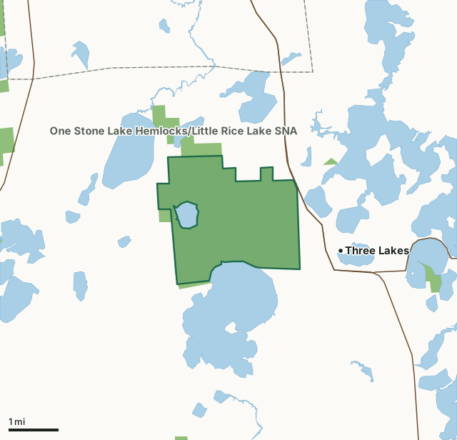
State wildlife areas, forests and other DNR landThunder Lake Wildlife AreaCounty lineLakeHighway
| Size | 3,253 acres |
|---|---|
| County | Oneida County |
| Deer Management Unit | DMU 120 |
| DNR lists for hunting | ducks and geese |
| Public access (DNR) | Open to Hiking, Fishing, Hunting and Trapping |
| DNR property page | Thunder Lake Wildlife Area |
| Nearest towns | Three Lakes (next to it), Eagle River (6 mi) and Rhinelander (15 mi) |
What is Thunder Lake Wildlife Area like?
Thunder Lake Wildlife Area is a 3,000-acre property in northeast Oneida County, one mile north of the village of Three Lakes. It consists of 50% open peat wetland (poor fen) and 50% forested tamarack/black spruce wetland with the 120-acre Rice Lake and 1.3 miles of shoreline on the 1,800-acre Thunder Lake. The whole property is open for hunting except for the waterfowl closed area around Rice Lake. The berms along the water ditches on the property are maintained for management access and provide excellent foot access to much of the property. A wide variety of wetland wildlife uses the property, including mallards, blue-winged teal, ring-necked ducks, great blue herons, sandhill cranes, Canada geese and numerous species of wetland songbirds. Three rare species, the Nelson sharp-tailed sparrow, merlin and the yellow rail nest on the property.
By 1920, the area had been cleared and drained for agriculture. However, agricultural efforts failed, and the land became tax delinquent. In 1952, Oneida County transferred the land to the state of Wisconsin for the development of a wildlife management area. During the 1950s and 1960s, prescribed fire was used to keep the property free of invading tamarack and black spruce and to support a remnant population of sharp-tailed grouse. By 1985, the sharp-tailed grouse had disappeared because suitable habitat declined to less than 2,000 acres. Today, the property is managed for wetland wildlife. The western half of the property is a large, wild state natural area, while the eastern half is managed as an open peatland. In the managed area, cutting and prescribed fire are used to maintain about 1,000 acres of open sedge, leatherleaf, cottongrass and bog birch peatland.
In the DNR's words, from its page for the property.
What can you hunt on Thunder Lake Wildlife Area?
The DNR's page for Thunder Lake Wildlife Area names ducks and geese. Each follows Wisconsin's statewide season and, for deer, the tags and rules of the deer management unit.
What are the rules on Thunder Lake Wildlife Area?
The DNR's property map lists Thunder Lake Wildlife Area as "Open to Hiking, Fishing, Hunting and Trapping". Hunting follows Wisconsin's statewide seasons and the rules posted on the property.
Activities the DNR lists for Thunder Lake Wildlife Area: Auto travel, Birding, Canoeing, Cross-country skiing (no designated trail), Hiking (no designated trail), Hunting (except the Waterfowl Closed Area around Rice Lake), Kayaking, Snowmobiling trail, Trapping, Wild edibles/gathering and Wildlife viewing.
How many deer are taken around Thunder Lake Wildlife Area?
Thunder Lake Wildlife Area lies in DMU 120. The DNR registered 1,155 deer in DMU 120 in 2025.
| DMU | Thunder Lake Wildlife Area acres in it | Deer, 2025 |
|---|---|---|
| DMU 120 | 3,253 | 1,155 |
Harvest for the whole deer management unit, not the property alone: Wisconsin DNR Deer Metrics (registered harvest by deer management unit).
How do you get to Thunder Lake Wildlife Area?
Nearest towns: Three Lakes (next to it), Eagle River (6 miles), Rhinelander (15 miles) and Lake Tomahawk (16 miles). Highways within 5 miles: US 45, WI 32 and WI 17.
What other public land is near Thunder Lake Wildlife Area?
DNR properties within 10 miles:
- One Stone Lake Hemlocks/Little Rice Lake SNA: 379 acres, next to it
- American Legion State Forest: 61,094 acres, 2.9 miles away
- Northern Highland State Forest: 176,323 acres, 3 miles away
- Sugar Camp Hemlocks State Natural Area: 80 acres, 3.1 miles away
- Pelican River Forest Conservation Easement: 67,444 acres, 4 miles away
Public land within 3 miles of Thunder Lake Wildlife Area
Counting Thunder Lake Wildlife Area itself, 3,780 of the 40,134 acres within 3 miles of its boundary are public land open to the public (9.4%), by USGS PAD-US 4.1 (fee land open to the public).
| Manager | Acres within 3 miles |
|---|---|
| State wildlife areas, forests and other DNR land | 3,780 |
Questions hunters ask
Where is Thunder Lake Wildlife Area?
In Oneida County, next to Three Lakes. The DNR's property page has its maps and parking.
Is Thunder Lake Wildlife Area open to hunting?
Yes. The DNR's property map lists it as "Open to Hiking, Fishing, Hunting and Trapping". Posted refuges or closed areas, where there are any, are marked on site.
Which deer management unit is Thunder Lake Wildlife Area in?
DMU 120.
How much public land is around Thunder Lake Wildlife Area?
3,780 acres within 3 miles of its boundary, Thunder Lake Wildlife Area included, by PAD-US 4.1. The closest other DNR property is One Stone Lake Hemlocks/Little Rice Lake SNA (next to it).
Get a Wisconsin hunt plan when they open
Hunt plans for Wisconsin are coming. Join the list and you'll hear first. The first 50 hunters in each new state get their plan free.
Until then, the free FilledTag app for iPhone has a map that works in every state, Wisconsin included.
Where these facts come from
- Area description, species, rules and directions: DNR, Thunder Lake Wildlife Area; Wisconsin DNR managed lands open to hunting.
- Boundary and acres: the DNR's map layer above. Surrounding public land: USGS PAD-US 4.1 (fee land open to the public).
- Deer harvest: Wisconsin DNR Deer Metrics (registered harvest by deer management unit).
FilledTag is not part of the Wisconsin Department of Natural Resources. Check the DNR's rules and posted signs before you go.