Totagatic Highlands Hemlocks State Natural Area: hunting and access
Totagatic Highlands Hemlocks State Natural Area is 160 acres of land managed by the Wisconsin DNR in Washburn County, 7 miles from Hayward. Hunters registered 2,406 deer in DMU 107 in 2025.
Data updated October 2026. Area facts: the DNR's DNR property data, read 2026-10. Harvest: DNR Deer Metrics.
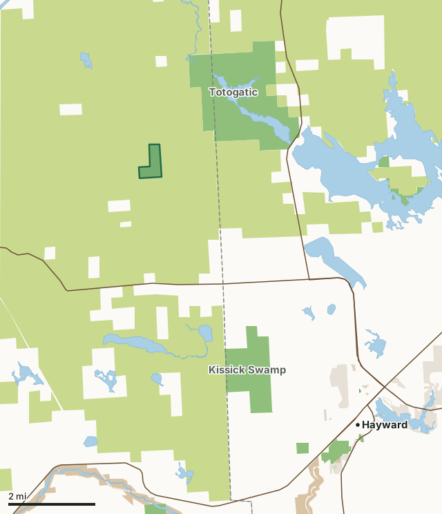
State wildlife areas, forests and other DNR landCounty forestNational forestNational park landOther county, city and regional landLand trusts and other open landTotagatic Highlands Hemlocks State Natural AreaCounty lineLakeHighway
| Size | 160 acres |
|---|---|
| County | Washburn County |
| Deer Management Unit | DMU 107 |
| Public access (DNR) | Open to Hiking, Fishing, Hunting and Trapping |
| DNR property page | Totagatic Highlands Hemlocks |
| Nearest towns | Hayward (7 mi), Springbrook (11 mi) and Minong (11 mi) |
What is Totagatic Highlands Hemlocks State Natural Area like?
Totagatic Highlands Hemlocks is an old-growth northern mesic and wet-mesic forest that includes a stand of large hemlock, here at its western range limit. The mesic forest contains hemlock with yellow birch, basswood, and elm. An impressive stand of northern white cedar dominates the wet-mesic forest, which appears untouched. The uplands have been only lightly cut in the past under the very conservative management of the Wisconsin State Trust Lands. The existence of both white cedar and hemlock above the snowline is unusual in this part of the state. The remote location adds to the site's natural value. Totagatic Highlands Hemlocks is owned by the DNR and was designated a State Natural Area in 1977. Washburn County. T42N-R10W, Sections 23, 26. 160 acres.
From the intersection of Highways 63 and 77 in Hayward, go north and west on 77 for 5.2 miles, then northwest on Olsen Road for about 1.4 miles. Walk or drive north as conditions permit on an access lane about 3 miles into the site. The access is rutted and difficult.
In the DNR's words, from its page for the property.
What are the rules on Totagatic Highlands Hemlocks State Natural Area?
The DNR's property map lists Totagatic Highlands Hemlocks State Natural Area as "Open to Hiking, Fishing, Hunting and Trapping". Hunting follows Wisconsin's statewide seasons and the rules posted on the property.
How many deer are taken around Totagatic Highlands Hemlocks State Natural Area?
Totagatic Highlands Hemlocks State Natural Area lies in DMU 107. The DNR registered 2,406 deer in DMU 107 in 2025.
| DMU | Totagatic Highlands Hemlocks State Natural Area acres in it | Deer, 2025 |
|---|---|---|
| DMU 107 | 160 | 2,406 |
Harvest for the whole deer management unit, not the property alone: Wisconsin DNR Deer Metrics (registered harvest by deer management unit).
How do you get to Totagatic Highlands Hemlocks State Natural Area?
Nearest towns: Hayward (7 miles), Springbrook (11 miles), Minong (11 miles) and Little Round Lake (13 miles). Highways within 5 miles: WI 77 and WI 27.
What other public land is near Totagatic Highlands Hemlocks State Natural Area?
DNR properties within 10 miles:
- Totogatic Wildlife Area: 2,664 acres, 1 mile away
- Kissick Swamp Wildlife Area: 933 acres, 3.9 miles away
- Big Island on Nelson State Habitat Area: 104 acres, 5 miles away
- Stress Springs State Spring Ponds: 45 acres, 6.9 miles away
- Hayward Nursery: 135 acres, 7.2 miles away
- Namekagon River State Habitat Area: 114 acres, 7.5 miles away
Public land within 3 miles of Totagatic Highlands Hemlocks State Natural Area
Counting Totagatic Highlands Hemlocks State Natural Area itself, 20,669 of the 22,702 acres within 3 miles of its boundary are public land open to the public (91%), by USGS PAD-US 4.1 (fee land open to the public).
| Manager | Acres within 3 miles |
|---|---|
| County forest | 18,119 |
| State wildlife areas, forests and other DNR land | 2,550 |
Questions hunters ask
Where is Totagatic Highlands Hemlocks State Natural Area?
In Washburn County, 7 miles from Hayward. The DNR's property page has its maps and parking.
Is Totagatic Highlands Hemlocks State Natural Area open to hunting?
Yes. The DNR's property map lists it as "Open to Hiking, Fishing, Hunting and Trapping". Posted refuges or closed areas, where there are any, are marked on site.
Which deer management unit is Totagatic Highlands Hemlocks State Natural Area in?
DMU 107.
How much public land is around Totagatic Highlands Hemlocks State Natural Area?
20,669 acres within 3 miles of its boundary, Totagatic Highlands Hemlocks State Natural Area included, by PAD-US 4.1. The closest other DNR property is Totogatic Wildlife Area (1 mile).
Get a Wisconsin hunt plan when they open
Hunt plans for Wisconsin are coming. Join the list and you'll hear first. The first 50 hunters in each new state get their plan free.
Until then, the free FilledTag app for iPhone has a map that works in every state, Wisconsin included.
Where these facts come from
- Area description, species, rules and directions: DNR, Totagatic Highlands Hemlocks State Natural Area; Wisconsin DNR managed lands open to hunting.
- Boundary and acres: the DNR's map layer above. Surrounding public land: USGS PAD-US 4.1 (fee land open to the public).
- Deer harvest: Wisconsin DNR Deer Metrics (registered harvest by deer management unit).
FilledTag is not part of the Wisconsin Department of Natural Resources. Check the DNR's rules and posted signs before you go.