Totagatic Lake Wildlife Area: hunting and access
Totagatic Lake Wildlife Area is 978 acres of land managed by the Wisconsin DNR in Bayfield County, 5 miles from Cable. The DNR's page for it names ducks and geese among the game here. Hunters registered 2,406 deer in DMU 107 in 2025.
Data updated October 2026. Area facts: the DNR's DNR property data, read 2026-10. Harvest: DNR Deer Metrics.
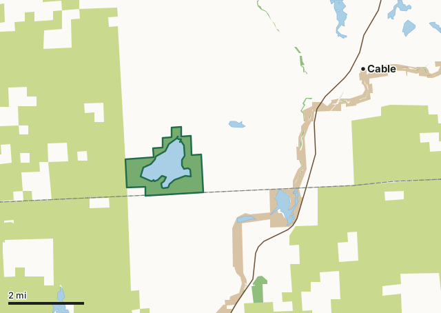
State wildlife areas, forests and other DNR landCounty forestNational park landOther county, city and regional landLand trusts and other open landTotagatic Lake Wildlife AreaCounty lineLakeHighway
| Size | 978 acres |
|---|---|
| County | Bayfield County |
| Deer Management Unit | DMU 107 |
| DNR lists for hunting | ducks and geese |
| Public access (DNR) | Open to Hiking, Fishing, Hunting and Trapping |
| DNR property page | Totagatic Lake Wildlife Area |
| Nearest towns | Cable (5 mi), Hayward (11 mi) and Little Round Lake (13 mi) |
What is Totagatic Lake Wildlife Area like?
Totagatic Lake Wildlife Management Area is a 1,403-acre property located in southwest Bayfield County. It includes the 537-acre Totagatic Lake, one of northwest Wisconsin's finest waterfowl hunting lakes. Totagatic Lake is also one of Wisconsin's premier wild rice-producing lakes, making it a highly valuable stopover for waterfowl migratory birds. The department and the Great Lakes Indian Fish and Wildlife Commission monitor rice production and harvest closely. Depending on production, ricing may be prohibited in certain years. The maximum lake depth is 8 feet, and the lake is heavily vegetated, making it susceptible to winter kill.
There is a public boat landing (non-motorized use only) on the southeast shore of the lake, facilitated by a small parking area. The fishery consists mainly of small northern pike and panfish. As such, there is some fishing activity, but the pressure is light. The main lake uses are waterfowl hunting and wild rice harvesting. Totagatic Lake provides excellent bird watching and other wildlife viewing opportunities. There is usually a pair of trumpeter swans nesting on the lake each year. The upland portions of the property offer numerous wildlife-related recreational opportunities since there is a good diversity of habitats and forest age classes found throughout the property. Grouse, deer and bear hunting are popular, and bird watching is good along the hunter walking trail located near the boat landing. Totagatic Lake is located in southwest Bayfield County.
In the DNR's words, from its page for the property.
What can you hunt on Totagatic Lake Wildlife Area?
The DNR's page for Totagatic Lake Wildlife Area names ducks and geese. Each follows Wisconsin's statewide season and, for deer, the tags and rules of the deer management unit.
What are the rules on Totagatic Lake Wildlife Area?
The DNR's property map lists Totagatic Lake Wildlife Area as "Open to Hiking, Fishing, Hunting and Trapping". Hunting follows Wisconsin's statewide seasons and the rules posted on the property.
Activities the DNR lists for Totagatic Lake Wildlife Area: Boating (non-motorized), Birding, Canoeing, Cross-country skiing (no designated trail), Fishing, Hiking (no designated trail), Hunting (noted for waterfowl), Kayaking, Trapping, Wild edibles/gathering, Wild rice harvesting and Wildlife viewing.
How many deer are taken around Totagatic Lake Wildlife Area?
Totagatic Lake Wildlife Area lies in DMU 107. The DNR registered 2,406 deer in DMU 107 in 2025.
| DMU | Totagatic Lake Wildlife Area acres in it | Deer, 2025 |
|---|---|---|
| DMU 107 | 978 | 2,406 |
Harvest for the whole deer management unit, not the property alone: Wisconsin DNR Deer Metrics (registered harvest by deer management unit).
How do you get to Totagatic Lake Wildlife Area?
Nearest towns: Cable (5 miles), Hayward (11 miles), Little Round Lake (13 miles) and Drummond (13 miles). Highways within 5 miles: US 63 and WI 27.
What other public land is near Totagatic Lake Wildlife Area?
DNR properties within 10 miles:
- Namekagon River Fishery Area: 61 acres, 2.4 miles away
- Uhrenholdt Mem Timber Demo Forest: 123 acres, 2.6 miles away
- Big Brook Brook Trout Reserves Easement Area: 70 acres, 2.8 miles away
- McDermott Brook Fishery Area: 154 acres, 4.3 miles away
- Totogatic Wildlife Area: 2,664 acres, 4.8 miles away
Public land within 3 miles of Totagatic Lake Wildlife Area
Counting Totagatic Lake Wildlife Area itself, 11,777 of the 32,165 acres within 3 miles of its boundary are public land open to the public (36.6%), by USGS PAD-US 4.1 (fee land open to the public).
| Manager | Acres within 3 miles |
|---|---|
| County forest | 9,695 |
| State wildlife areas, forests and other DNR land | 1,099 |
| National park land | 977 |
| Land trusts and other open land | 6 |
Questions hunters ask
Where is Totagatic Lake Wildlife Area?
In Bayfield County, 5 miles from Cable. The DNR's property page has its maps and parking.
Is Totagatic Lake Wildlife Area open to hunting?
Yes. The DNR's property map lists it as "Open to Hiking, Fishing, Hunting and Trapping". Posted refuges or closed areas, where there are any, are marked on site.
Which deer management unit is Totagatic Lake Wildlife Area in?
DMU 107.
How much public land is around Totagatic Lake Wildlife Area?
11,777 acres within 3 miles of its boundary, Totagatic Lake Wildlife Area included, by PAD-US 4.1. The closest other DNR property is Namekagon River Fishery Area (2.4 miles).
Get a Wisconsin hunt plan when they open
Hunt plans for Wisconsin are coming. Join the list and you'll hear first. The first 50 hunters in each new state get their plan free.
Until then, the free FilledTag app for iPhone has a map that works in every state, Wisconsin included.
Where these facts come from
- Area description, species, rules and directions: DNR, Totagatic Lake Wildlife Area; Wisconsin DNR managed lands open to hunting.
- Boundary and acres: the DNR's map layer above. Surrounding public land: USGS PAD-US 4.1 (fee land open to the public).
- Deer harvest: Wisconsin DNR Deer Metrics (registered harvest by deer management unit).
FilledTag is not part of the Wisconsin Department of Natural Resources. Check the DNR's rules and posted signs before you go.