Trout Creek Fishery Area-Iowa: hunting and access
Trout Creek Fishery Area-Iowa is 954 acres of land managed by the Wisconsin DNR in Iowa County, 2 miles from Barneveld. Hunters registered 2,948 deer in Iowa County in 2025.
Data updated October 2026. Area facts: the DNR's DNR property data, read 2026-10. Harvest: DNR Deer Metrics.
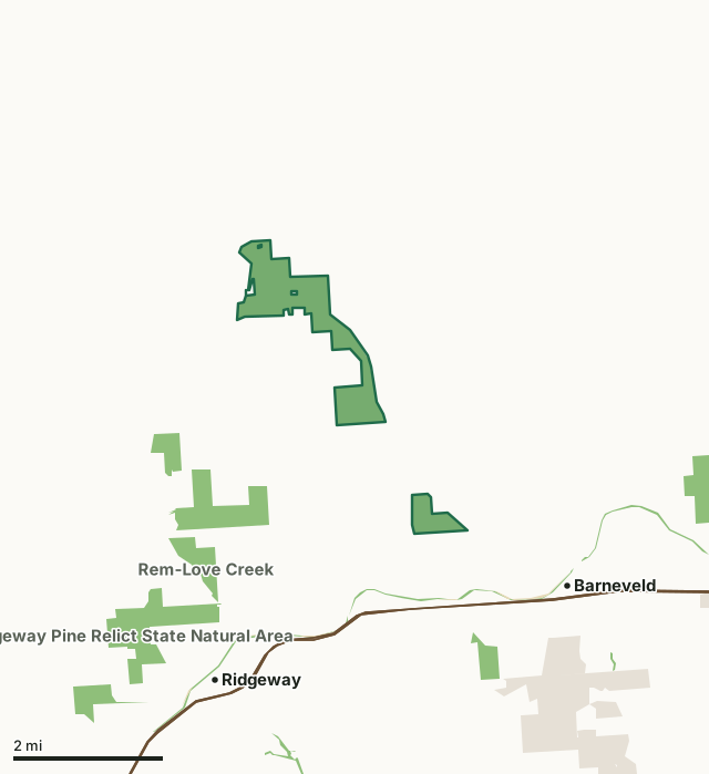
State wildlife areas, forests and other DNR landState parksLand trusts and other open landTrout Creek Fishery Area-IowaCounty lineHighway
| Size | 954 acres in 2 pieces |
|---|---|
| County | Iowa County |
| Deer Management Unit | Iowa County |
| Public access (DNR) | Open to Hiking, Fishing, Hunting and Trapping |
| DNR property page | Trout Creek Fishery Area (Iowa County) |
| Nearest towns | Barneveld (2 mi), Ridgeway (3 mi) and Blue Mounds (5 mi) |
What is Trout Creek Fishery Area-Iowa like?
Trout Creek Fishery Area is the first named Fishery Area in Southwest Wisconsin along what was at that time considered to be the best class 1 brown trout fishery in this part of the State. It was originally designed with a meets and bounds description along the banks of the stream to provide fishing access and stream development rights. It was later given a greatly enlarged boundary that includes the uplands along the corridor. Trout Creek is codified as an Exceptional Resource Waters (ERW). This is one of the most studied class 1 trout fisheries in the State. It also contains significant cultural resources.
Trout Creek Fishery Area is at the junction with Mill Creek (T 7N, R 4E, section 13) upstream to Birch Lake Dam (T 6N, R 5E, section 4). The Trout Creek Fishery Area is managed to provide for a high quality, scenic fishing opportunity on a class 1 brown trout fishery close to Madison. Harry and Laura Nohr Chapter of Trout Unlimited [exit DNR] Southern Wisconsin Chapter Trout Unlimited [exit DNR].
In the DNR's words, from its page for the property.
What are the rules on Trout Creek Fishery Area-Iowa?
The DNR's property map lists Trout Creek Fishery Area-Iowa as "Open to Hiking, Fishing, Hunting and Trapping". Hunting follows Wisconsin's statewide seasons and the rules posted on the property.
Activities the DNR lists for Trout Creek Fishery Area-Iowa: Hunting, Trapping, Hiking and Wildlife viewing.
How many deer are taken around Trout Creek Fishery Area-Iowa?
Trout Creek Fishery Area-Iowa lies in Iowa County. The DNR registered 2,948 deer in Iowa County in 2025, against 3,020 in 2024.
| DMU | Trout Creek Fishery Area-Iowa acres in it | Deer, 2025 | Deer, 2024 | Deer, 2023 |
|---|---|---|---|---|
| Iowa County | 954 | 2,948 | 3,020 | 3,533 |
Harvest for the whole deer management unit, not the property alone: Wisconsin DNR Deer Metrics (registered harvest by deer management unit).
How do you get to Trout Creek Fishery Area-Iowa?
Nearest towns: Barneveld (2 miles), Ridgeway (3 miles), Blue Mounds (5 miles) and Arena (7 miles). Highways within 5 miles: US 151 and US 18.
What other public land is near Trout Creek Fishery Area-Iowa?
DNR properties within 10 miles:
- Military Ridge State Trail: 519 acres, 0.8 miles away
- Ridgeway Pine Relict State Natural Area: 551 acres, 2.7 miles away
- Blue Mound State Park: 1,163 acres, 2.9 miles away
- Smith-Conley Creek SBE Area: 123 acres, 3.3 miles away
Public land within 3 miles of Trout Creek Fishery Area-Iowa
Counting Trout Creek Fishery Area-Iowa itself, 2,484 of the 40,586 acres within 3 miles of its boundary are public land open to the public (6.1%), by USGS PAD-US 4.1 (fee land open to the public).
| Manager | Acres within 3 miles |
|---|---|
| State wildlife areas, forests and other DNR land | 1,754 |
| Land trusts and other open land | 714 |
| State parks | 16 |
Questions hunters ask
Where is Trout Creek Fishery Area-Iowa?
In Iowa County, 2 miles from Barneveld. The DNR's property page has its maps and parking.
Is Trout Creek Fishery Area-Iowa open to hunting?
Yes. The DNR's property map lists it as "Open to Hiking, Fishing, Hunting and Trapping". Posted refuges or closed areas, where there are any, are marked on site.
Which deer management unit is Trout Creek Fishery Area-Iowa in?
Iowa County.
How much public land is around Trout Creek Fishery Area-Iowa?
2,484 acres within 3 miles of its boundary, Trout Creek Fishery Area-Iowa included, by PAD-US 4.1. The closest other DNR property is Military Ridge State Trail (0.8 miles).
Get a Wisconsin hunt plan when they open
Hunt plans for Wisconsin are coming. Join the list and you'll hear first. The first 50 hunters in each new state get their plan free.
Until then, the free FilledTag app for iPhone has a map that works in every state, Wisconsin included.
Where these facts come from
- Area description, species, rules and directions: DNR, Trout Creek Fishery Area-Iowa; Wisconsin DNR managed lands open to hunting.
- Boundary and acres: the DNR's map layer above. Surrounding public land: USGS PAD-US 4.1 (fee land open to the public).
- Deer harvest: Wisconsin DNR Deer Metrics (registered harvest by deer management unit).
FilledTag is not part of the Wisconsin Department of Natural Resources. Check the DNR's rules and posted signs before you go.